
| NORTH BUFFALO SUB (CLOSED) LOCKPORT NY |
| |
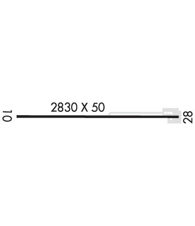
| Lat: N 4306.2 Long: W 07842.2 Elev: 588 Var: +11 Longest Runway: 2830 | ||
| CTAF: 123.0 | ||
| |||||
|
| Rwy | Rwy | |||||||
| 2830x50 | 2830' | 2830x50 | 2475' | |||||
| Runway ID | Single Wheel | Double Wheel | Double Tandem Wheel | Dual Double Wheel |
| 10/28 | 6,000 | N/A | N/A | N/A |
| These numbers are Advisory and are not limits. The Airport Manager should have more accurate Weight Limits | ||||
| FltPlan does not have IFR approach charts available for K0G0. |
 Airport Diagram might not be current. | |
| Facility Name: | NORTH BUFFALO SUBURBAN |
| City Name: | LOCKPORT |
| County: | NIAGARA |
| State abbrev: | NY |
| State Name: | NEW YORK |
| Ownership: | PRIVATELY OWNED |
| Use: | OPEN TO THE PUBLIC |
| Owner's Name: | GARY LEASING INC. |
| Address: | 67OO TRANSIT ROAD |
| LOCKPORT, NY 14094 | |
| Owner's Phone: | 716-625-8111 |
| Manager's Name: | DANNY REIDY |
| Address: | 6700 TRANSIT ROAD |
| LOCKPORT, NY 14094 | |
| Phone: | 716-625-8111 |
| FAA Region: | EASTERN |
| FAA Field Office: | NYC |
| Date | Sunrise | Sunset |
|---|---|---|
| 07/21/25 Monday | 5:54 | 20:48 |
| 07/22/25 Tuesday | 5:55 | 20:47 |
| 07/23/25 Wednesday | 5:56 | 20:46 |
| 07/24/25 Thursday | 5:57 | 20:45 |
| 07/25/25 Friday | 5:58 | 20:44 |
| 07/26/25 Saturday | 5:59 | 20:43 |
| 07/27/25 Sunday | 6:00 | 20:42 |
| 07/28/25 Monday | 6:01 | 20:41 |
| 07/29/25 Tuesday | 6:02 | 20:40 |
| 07/30/25 Wednesday | 6:03 | 20:39 |
| 07/31/25 Thursday | 6:04 | 20:38 |
| 08/01/25 Friday | 6:05 | 20:37 |
| 08/02/25 Saturday | 6:06 | 20:35 |
| 08/03/25 Sunday | 6:07 | 20:34 |
| Airport Attendance Schedule | 7 Days A Week 0830-1700 |
| Airport Status | OPERATIONAL (This Status can change at any time - please check NOTAMS) |
| Airport Lighting Schedule | ACTVT MIRL RWY 10/28 - 123.0.; BEACON OTS INDEFLY. |
| Airport Storage Available | Tie Downs, Hanger |
| Extra Services Available | NONE |
| Wind Indicator | YES - (unlit) |
| Control Tower | NO |
| CTAF Frequency | 123.000 |
| Unicom Frequency | 123.000 |
| Rotating Beacon Color | CLEAR-GREEN (Light Land Airport) |
| Segmented Circle | NO |
| Landing Fee | NO |
| Airport Inspected | STATE - performed by STATE AERONAUTICAL PERSONNEL |
| Inspection Date | 05/09/2019 |
| Type of Fuel Available | Grade 100LL |
| Airframe Repair Service | None |
| Power Plant Repair Service | None |
| Latitude | N4306.2 |
| Longitude | W07842.2 (ESTIMATED) |
| Arpt Elevation | 588ft (ESTIMATED) |
| Magnetic Variation | 11W |
| 3 miles S | of LOCKPORT |
| Traffic Pattern Altitude | 813 |
| Sectional Chart | DETROIT |
| Operations (Reported) | Yearly | Avg. Daily |
|---|---|---|
| General Aviation Transient | 0 | 0 |
| General Aviation Local | 3600 | 10 |
| Air Taxi | 0 | 0 |
| Commerical | 0 | 0 |
| Commuter | 0 | 0 |
| Military | 0 | 0 |
| Aircraft based on Field | |
|---|---|
| General Aviation Singles | 0 |
| General Aviation Multi | 0 |
| Jet Aircraft | 0 |
| General Aviation Helicopters | 0 |
| Military Aircraft | 0 |
| Gliders | 0 |
| Ultralights | 0 |
| FSS on field | NO |
| FSS tie-in | BUFFALO |
| FSS Phone | 1-800-WX-BRIEF |
| Who issues Notams | BUF |
| Notam D service at airport | YES |
| ARTCC Name | CLEVELAND |
| Airport Certification | |
| Aircraft Rescue & Firefighting Index | None |
| Airport of Entry | No |
| Custom Landing Rights | No |
| Joint Civil/Military | No |
| Military Landing rights | No |
| RWY SAFETY AREA 500 FT LENGTH BY 60 FT WIDTH, W END RWY 10. |
| FOR CD CTC CLEVELAND ARTCC AT 440-774-0490. |
| RWY 10/2 8 ASPHALT BROKEN ALONG RUNWAY NORTH EDGE IN SEVERAL AREAS; MARKED BY ORANGE CONES. |
| RWY 10/2 8 MIRL OPR LOW INTST ONLY. |
Airport Communications & Frequencies:
| ||||||||||||||
| Runway: 10 | Runway: 28 | ||
| Mag heading: | 102° | Mag heading: | 282° |
| Rwy Slope: | .01% Up | Rwy Slope: | -.01% Down |
| Approach: | Approach: | ||
| Pattern: | Left Traffic | Pattern: | Left Traffic |
| Markings: | BASIC | Markings: | BASIC |
| Marking Condition: | FAIR | Marking Condition: | FAIR |
| Arresting Dev: | Arresting Dev: | ||
| Lat & Long: | N4306.2 W07842.5 | Lat. & Long.: | N4306.2 W07841.9 |
| Elev: | 588.0 ft. MSL | Elev: | 588.4 ft. MSL |
| TCH: | TCH: | ||
| Visual Glide Path: | Visual Glide Path: | 3.00 degrees | |
| Displaced Threshold: | No | Displaced Threshold: | 355 feet |
| Touchdown Zone: | YES | Touchdown Zone: | YES |
| Touchdown Elev.: | 588.4 feet | Touchdown Elev.: | 588.4 feet |
| Visual Glide Slope: | Visual Glide Slope: | TRI-COLOR VASI ON LEFT SIDE OF RUNWAY; OTS INDEFLY. | |
| RVR Equipment: | RVR Equipment: | ||
| RVV Equipment: | NO | RVV Equipment: | NO |
| Approach Lights: | Approach Lights: | ||
| REIL: | NO | REIL: | NO |
| Centerline Lights: | NO | Centerline Lights: | NO |
| Touchdown lights: | NO | Touchdown lights: | NO |
| Runway Category: | Runway with a Non-precision Approach | Runway Category: | Runway with a Non-precision Approach |
| Declared Distances: | Declared Distances: | ||
| Obstructions: | TREES | Obstructions: | PLINE |
| Marked: | NOT Marked/Lighted | Marked: | NOT Marked/Lighted |
| Clearance slope: | Clearance slope: | 2:1; APCH RATIO 17:1 TO DTHR. | |
| Obstruction height: | 59 feet AGL | Obstruction height: | 37 feet AGL |
| Dist. from runway: | 232 feet | Dist. from runway: | 280 feet |
| Centerline offset: | 71 left of centerline | Centerline offset: | |
| Comments: | 34 FT TREE, 0 FT FM RWY END, 79 FT LEFT. | Comments: | 31 FT BLDG WITH ANT 82 FT FM RWY END 38 FT LEFT; 28 FT POLE 67 FT FM RWY END 138 RIGHT; 34 FT POLE 281 FT FM RWY END 149 FT RIGHT; 24 FT FLAGPOLE 57 FT FM RWY END 88 FT LEFT. |
Thanks for using FltPlan.com
all rights reserved © 1999-2025 by Flight Plan LLC
