
| SPIRIT LAKE MUNI SPIRIT LAKE IA |
| |
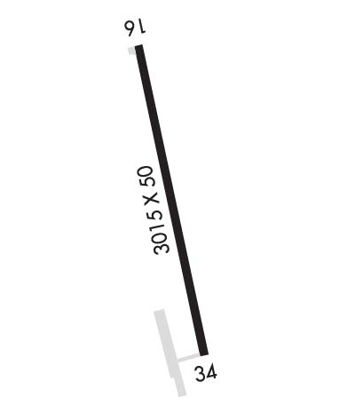
| Lat: N 4323.2 Long: W 09508.4 Elev: 1434 Var: -05 Longest Runway: 3015 | ||
| CTAF: 122.7 | ||
| ||||||
|
| Rwy | Rwy | |||||||
| 3015x50 | 3015' | 3015x50 | 3015' | |||||
| Runway ID | Single Wheel | Double Wheel | Double Tandem Wheel | Dual Double Wheel |
| 16/34 | N/A | N/A | N/A | N/A |
| These numbers are Advisory and are not limits. The Airport Manager should have more accurate Weight Limits | ||||
| FltPlan does not have IFR approach charts available for K0F3. |
 Airport Diagram might not be current. | |
| Facility Name: | SPIRIT LAKE MUNI |
| City Name: | SPIRIT LAKE |
| County: | DICKINSON |
| State abbrev: | IA |
| State Name: | IOWA |
| Ownership: | PUBLICLY OWNED |
| Use: | OPEN TO THE PUBLIC |
| Owner's Name: | DICKINSON COUNTY ARPT AUTH; ARPT AUTHORITY CHAIRMAN - BRUCE SMITH - 712-332-7323. |
| Address: | BOX 702 |
| OKOBOJI, IA 51355 | |
| Owner's Phone: | 712-332-9412 |
| Manager's Name: | DICKINSON COUNTY ARPT AUTH; BRUCE SMITH |
| Address: | BOX 702 |
| OKOBOJI, IA 51355 | |
| Phone: | 712-332-9412 |
| FAA Region: | CENTRAL |
| FAA Field Office: | NONE |
| Date | Sunrise | Sunset |
|---|---|---|
| 09/24/21 Friday | 7:10 | 19:15 |
| 09/25/21 Saturday | 7:11 | 19:13 |
| 09/26/21 Sunday | 7:12 | 19:11 |
| 09/27/21 Monday | 7:13 | 19:09 |
| 09/28/21 Tuesday | 7:14 | 19:07 |
| 09/29/21 Wednesday | 7:15 | 19:06 |
| 09/30/21 Thursday | 7:17 | 19:04 |
| 10/01/21 Friday | 7:18 | 19:02 |
| 10/02/21 Saturday | 7:19 | 19:00 |
| 10/03/21 Sunday | 7:20 | 18:58 |
| 10/04/21 Monday | 7:21 | 18:57 |
| 10/05/21 Tuesday | 7:22 | 18:55 |
| 10/06/21 Wednesday | 7:24 | 18:53 |
| 10/07/21 Thursday | 7:25 | 18:51 |
| Airport Attendance Schedule | MAY-SEP 7 Days A Week IRREG |
| Airport Status | OPERATIONAL (This Status can change at any time - please check NOTAMS) |
| Airport Lighting Schedule | DUSK-DAWN. ACTVT REIL RY 16 - CTAF. |
| Airport Storage Available | Tie Downs, Hanger |
| Extra Services Available | NONE |
| Wind Indicator | YES - (lighted) |
| Control Tower | NO |
| CTAF Frequency | 122.700 |
| Unicom Frequency | 122.700 |
| Rotating Beacon Color | |
| Segmented Circle | NO |
| Landing Fee | NO |
| Airport Inspected | STATE - performed by STATE AERONAUTICAL PERSONNEL |
| Inspection Date | 12/16/2020 |
| Type of Fuel Available | None |
| Airframe Repair Service | None |
| Power Plant Repair Service | None |
| Latitude | N4323.2 |
| Longitude | W09508.4 (ESTIMATED) |
| Arpt Elevation | 1434ft (SURVEYED) |
| Magnetic Variation | 05E |
| 3 miles SW | of SPIRIT LAKE |
| Traffic Pattern Altitude | |
| Sectional Chart | OMAHA |
| Operations (Reported) | Yearly | Avg. Daily |
|---|---|---|
| General Aviation Transient | 2387 | 7 |
| General Aviation Local | 1813 | 5 |
| Air Taxi | 0 | 0 |
| Commerical | 0 | 0 |
| Commuter | 0 | 0 |
| Military | 0 | 0 |
| Aircraft based on Field | |
|---|---|
| General Aviation Singles | 18; BASED ACFT 40 SEASONALLY MAY-SEP. |
| General Aviation Multi | 0 |
| Jet Aircraft | 1 |
| General Aviation Helicopters | 0 |
| Military Aircraft | 0 |
| Gliders | 0 |
| Ultralights | 0 |
| FSS on field | NO |
| FSS tie-in | FORT DODGE |
| FSS Phone | 1-800-WX-BRIEF |
| Who issues Notams | FOD |
| Notam D service at airport | YES |
| ARTCC Name | MINNEAPOLIS |
| Airport Certification | |
| Aircraft Rescue & Firefighting Index | None |
| Airport of Entry | No |
| Custom Landing Rights | No |
| Joint Civil/Military | No |
| Military Landing rights | YES |
| TALL WTR TANK AT 1635 FT MSL LCTD APRX 1830 FT ABM AND WEST OF RWY 16/34. EXER CTN WHILE IN ARPT TFC PAT. |
| FOR CD CTC MINNEAPOLIS ARTCC AT 651-463-5588. |
| Runway: 16 | Runway: 34 | ||
| Mag heading: | 162° | Mag heading: | 342° |
| Rwy Slope: | -.46% Down | Rwy Slope: | .46% Up |
| Approach: | Approach: | ||
| Pattern: | Left Traffic | Pattern: | Left Traffic |
| Markings: | BASIC | Markings: | BASIC |
| Marking Condition: | GOOD | Marking Condition: | GOOD |
| Arresting Dev: | Arresting Dev: | ||
| Lat & Long: | N4323.5 W09508.4 | Lat. & Long.: | N4323.0 W09508.3 |
| Elev: | 1434.0 ft. MSL | Elev: | 1420.0 ft. MSL |
| TCH: | TCH: | ||
| Visual Glide Path: | Visual Glide Path: | ||
| Displaced Threshold: | No | Displaced Threshold: | No |
| Touchdown Zone: | NO | Touchdown Zone: | NO |
| Touchdown Elev.: | Touchdown Elev.: | ||
| Visual Glide Slope: | Visual Glide Slope: | ||
| RVR Equipment: | RVR Equipment: | ||
| RVV Equipment: | NO | RVV Equipment: | NO |
| Approach Lights: | Approach Lights: | ||
| REIL: | YES | REIL: | NO |
| Centerline Lights: | NO | Centerline Lights: | NO |
| Touchdown lights: | NO | Touchdown lights: | NO |
| Runway Category: | Runway with a Visual Approach | Runway Category: | Runway with a Visual Approach |
| Declared Distances: | Declared Distances: | ||
| Obstructions: | GND | Obstructions: | TREE |
| Marked: | NOT Marked/Lighted | Marked: | NOT Marked/Lighted |
| Clearance slope: | 32:1 | Clearance slope: | 20:1 |
| Obstruction height: | 10 feet AGL | Obstruction height: | 42 feet AGL |
| Dist. from runway: | 520 feet; +30' TREES 100' RIGHT OF RWY CNTRLN EXTNDD 520' FROM AER. | Dist. from runway: | 1080 feet |
| Centerline offset: | B | Centerline offset: | 73 feet left of centerline |
| Comments: | Comments: |
Thanks for using FltPlan.com
all rights reserved © 1999-2021 by Flight Plan LLC
