
| ELIZABETH FIELD FISHERS ISLAND NY |
| |
| Lat: N 4115.1 Long: W 07201.9 Elev: 7 Var: +14 Longest Runway: 2345 | ||
| CTAF: 122.8 | ||
| ||||||||||||||||||||||||||||||||
| ||||||||||||||||||||||||||||||||
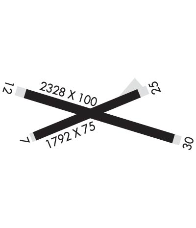
| Rwy | Rwy | |||||||
| 1806x75 | 1806' | 1806x75 | 1806' | |||||
| 2345x100 | 2345' | 2345x100 | 2345' | |||||
| Runway ID | Single Wheel | Double Wheel | Double Tandem Wheel | Dual Double Wheel |
| 07/25 | N/A | N/A | N/A | N/A |
| 12/30 | N/A | N/A | N/A | N/A |
| These numbers are Advisory and are not limits. The Airport Manager should have more accurate Weight Limits | ||||
 Airport Diagram might not be current. | |
| Facility Name: | ELIZABETH FLD |
| City Name: | FISHERS ISLAND |
| County: | SUFFOLK |
| State abbrev: | NY |
| State Name: | NEW YORK |
| Ownership: | PUBLICLY OWNED |
| Use: | OPEN TO THE PUBLIC |
| Owner's Name: | TOWN OF SOUTHOLD |
| Address: | PO BOX 607 |
| FISHERS ISLAND, NY 06390 | |
| Owner's Phone: | 631-765-1800 |
| Manager's Name: | GORDON MURPHY |
| Address: | PO BOX 607 |
| FISHERS ISLAND, NY 06390 | |
| Phone: | 631-788-7463; OR 860-460-7174 WHEN ATTENDED. |
| FAA Region: | EASTERN |
| FAA Field Office: | NYC |

| Date | Sunrise | Sunset |
|---|---|---|
| 09/24/21 Friday | 6:37 | 18:42 |
| 09/25/21 Saturday | 6:38 | 18:41 |
| 09/26/21 Sunday | 6:39 | 18:39 |
| 09/27/21 Monday | 6:40 | 18:37 |
| 09/28/21 Tuesday | 6:41 | 18:36 |
| 09/29/21 Wednesday | 6:42 | 18:34 |
| 09/30/21 Thursday | 6:43 | 18:32 |
| 10/01/21 Friday | 6:45 | 18:30 |
| 10/02/21 Saturday | 6:46 | 18:29 |
| 10/03/21 Sunday | 6:47 | 18:27 |
| 10/04/21 Monday | 6:48 | 18:25 |
| 10/05/21 Tuesday | 6:49 | 18:24 |
| 10/06/21 Wednesday | 6:50 | 18:22 |
| 10/07/21 Thursday | 6:51 | 18:20 |
| Airport Attendance Schedule | MAY-OCT SUN 1000-1630, MAY-OCT MON-SAT 0800-1630, 1 NOV-30 APR UNATNDD |
| Airport Status | OPERATIONAL (This Status can change at any time - please check NOTAMS) |
| Airport Lighting Schedule | ACTVT REIL RY 07/25 & RY 12/30; PAPI RY 07/25 & RY 12/30; MIRL RY 07/25 & RY 12/30 - CTAF. |
| Airport Storage Available | Tie Downs |
| Extra Services Available | NONE |
| Wind Indicator | YES - (lighted) |
| Control Tower | NO |
| CTAF Frequency | 122.800 |
| Unicom Frequency | 122.800 |
| Rotating Beacon Color | |
| Segmented Circle | NO |
| Landing Fee | YES |
| Airport Inspected | STATE - performed by STATE AERONAUTICAL PERSONNEL |
| Inspection Date | 06/03/2019 |
| Type of Fuel Available | None |
| Airframe Repair Service | NONE |
| Power Plant Repair Service | NONE |
| Latitude | N4115.1 |
| Longitude | W07201.9 (ESTIMATED) |
| Arpt Elevation | 7ft (SURVEYED) |
| Magnetic Variation | 14W |
| 8 miles SE | of FISHERS ISLAND |
| Traffic Pattern Altitude | |
| Sectional Chart | NEW YORK |
| Operations (Reported) | Yearly | Avg. Daily |
|---|---|---|
| General Aviation Transient | 500 | 1 |
| General Aviation Local | 500 | 1 |
| Air Taxi | 1100 | 3 |
| Commerical | 0 | 0 |
| Commuter | 0 | 0 |
| Military | 25 | 0 |
| Aircraft based on Field | |
|---|---|
| General Aviation Singles | 2 |
| General Aviation Multi | 0 |
| Jet Aircraft | 0 |
| General Aviation Helicopters | 0 |
| Military Aircraft | 0 |
| Gliders | 0 |
| Ultralights | 0 |
| FSS on field | NO |
| FSS tie-in | BRIDGEPORT |
| FSS Phone | 1-800-WX-BRIEF |
| Who issues Notams | BDR |
| Notam D service at airport | YES |
| ARTCC Name | BOSTON |
| Airport Certification | |
| Aircraft Rescue & Firefighting Index | None |
| Airport of Entry | No |
| Custom Landing Rights | No |
| Joint Civil/Military | No |
| Military Landing rights | YES |
| NATIONAL PLAN OF INTEGRATED AIRPORT SYSTEMS (NPIAS) |
| SURPLUS PROPERTY AGREEMENT UNDER PUBLIC LAW 289 |
| (A17) ARPT ATTENDED MAY-OCT MON THRU SAT 0800-1630; SUN 1000-1630; UNATNDD NOV-APR. |
| FOR CD CTC PROVIDENCE APCH AT 401-738-8945, WHEN APCH CLSD CTC BOSTON ARTCC AT 603-879-6859. |
Airport Communications & Frequencies:
| |||||||||||||||||
| Runway: 07 | Runway: 25 | ||
| Mag heading: | 75° | Mag heading: | 255° |
| Rwy Slope: | .16% Up | Rwy Slope: | -.16% Down |
| Approach: | Approach: | ||
| Pattern: | Left Traffic | Pattern: | Left Traffic |
| Markings: | BASIC | Markings: | BASIC |
| Marking Condition: | GOOD | Marking Condition: | GOOD |
| Arresting Dev: | Arresting Dev: | ||
| Lat & Long: | N4115.1 W07202.1 | Lat. & Long.: | N4115.2 W07201.7 |
| Elev: | 4.3 ft. MSL | Elev: | 7.2 ft. MSL |
| TCH: | 20 ft. AGL | TCH: | 20 ft. AGL |
| Visual Glide Path: | 3.75 degrees | Visual Glide Path: | 3.00 degrees |
| Displaced Threshold: | No | Displaced Threshold: | No |
| Touchdown Zone: | YES | Touchdown Zone: | YES |
| Touchdown Elev.: | 7.2 feet | Touchdown Elev.: | 7.2 feet |
| Visual Glide Slope: | 2-Light PAPI on LEFT side of Runway | Visual Glide Slope: | 2-Light PAPI on LEFT side of Runway |
| RVR Equipment: | RVR Equipment: | ||
| RVV Equipment: | NO | RVV Equipment: | NO |
| Approach Lights: | Approach Lights: | ||
| REIL: | YES | REIL: | YES |
| Centerline Lights: | NO | Centerline Lights: | NO |
| Touchdown lights: | NO | Touchdown lights: | NO |
| Runway Category: | Runway with a Visual Approach | Runway Category: | Runway with a Visual Approach |
| Declared Distances: | Declared Distances: | ||
| Obstructions: | GND; 24 FT DUNE. | Obstructions: | ROAD |
| Marked: | LIGHTED | Marked: | NOT Marked/Lighted |
| Clearance slope: | 5:1 | Clearance slope: | 4:1 |
| Obstruction height: | 30 feet AGL | Obstruction height: | 10 feet AGL |
| Dist. from runway: | 363 feet | Dist. from runway: | 246 feet |
| Centerline offset: | 141 left of centerline | Centerline offset: | 22 feet right of centerline |
| Comments: | RWY 07; 6 FT ROCK/GRAVEL DUNE PARALLEL TO RWY 75 FT R. 6 FT ROCK/GRAVEL DUNE 165 FT FROM RWY PERPENDICULAR TO RWY. | Comments: | RWY 25; +7 FT BRUSH 170-180 FT FROM THLD 42-61 FT L. |
| Runway: 12 | Runway: 30 | ||
| Mag heading: | 115° | Mag heading: | 295° |
| Rwy Slope: | -.12% Down | Rwy Slope: | .12% Up |
| Approach: | Approach: | ||
| Pattern: | Left Traffic | Pattern: | Left Traffic |
| Markings: | BASIC | Markings: | BASIC |
| Marking Condition: | GOOD | Marking Condition: | GOOD |
| Arresting Dev: | Arresting Dev: | ||
| Lat & Long: | N4115.2 W07202.1 | Lat. & Long.: | N4115.1 W07201.6 |
| Elev: | 6.7 ft. MSL | Elev: | 3.9 ft. MSL |
| TCH: | 20 ft. AGL | TCH: | 20 ft. AGL |
| Visual Glide Path: | 3.00 degrees | Visual Glide Path: | 3.00 degrees |
| Displaced Threshold: | No | Displaced Threshold: | No |
| Touchdown Zone: | YES | Touchdown Zone: | YES |
| Touchdown Elev.: | 6.8 feet | Touchdown Elev.: | 6.8 feet |
| Visual Glide Slope: | 2-Light PAPI on LEFT side of Runway | Visual Glide Slope: | 2-Light PAPI on RIGHT side of Runway |
| RVR Equipment: | RVR Equipment: | ||
| RVV Equipment: | NO | RVV Equipment: | NO |
| Approach Lights: | Approach Lights: | ||
| REIL: | YES | REIL: | YES |
| Centerline Lights: | NO | Centerline Lights: | NO |
| Touchdown lights: | NO | Touchdown lights: | NO |
| Runway Category: | Runway with a Visual Approach | Runway Category: | Runway with a Visual Approach |
| Declared Distances: | Declared Distances: | ||
| Obstructions: | ROAD; RY 12, 2.5 FT SIGN POST 202 FT FM THLD 87 FT RT; 2.5 FT SIGN POS , 202 FT FM THLD 78 FT L. | Obstructions: | OTHER; RY 30, 5 FT ROCK SEAWALL 70-85 FT L PARALLEL TO RY. |
| Marked: | NOT Marked/Lighted | Marked: | NOT Marked/Lighted |
| Clearance slope: | Clearance slope: | ||
| Obstruction height: | 15 feet AGL | Obstruction height: | 5 feet AGL |
| Dist. from runway: | 200 feet | Dist. from runway: | 200 feet |
| Centerline offset: | B | Centerline offset: | 78 feet left of centerline |
| Comments: | RWY12; +15FT RD PARALLEL TO RWY 90 FT L. | Comments: |
Thanks for using FltPlan.com
all rights reserved © 1999-2021 by Flight Plan LLC