
| ROCKWELL CITY MUNI ROCKWELL CITY IA |
| |
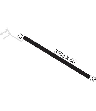
| Lat: N 4223.3 Long: W 09437.1 Elev: 1216 Var: -05 Longest Runway: 3503 | ||
| CTAF: 122.8 | ||
| ||||||
|
| Rwy | Rwy | |||||||
| 3503x60 | 2298' | 3503x60 | 3503' | |||||
| Runway ID | Single Wheel | Double Wheel | Double Tandem Wheel | Dual Double Wheel |
| 12/30 | N/A | N/A | N/A | N/A |
| These numbers are Advisory and are not limits. The Airport Manager should have more accurate Weight Limits | ||||
| FltPlan does not have IFR approach charts available for K2Y4. |
 Airport Diagram might not be current. | |
| Facility Name: | ROCKWELL CITY MUNI |
| City Name: | ROCKWELL CITY |
| County: | CALHOUN |
| State abbrev: | IA |
| State Name: | IOWA |
| Ownership: | PUBLICLY OWNED |
| Use: | OPEN TO THE PUBLIC |
| Owner's Name: | ROCKWELL CITY |
| Address: | 335 MAIN |
| ROCKWELL CITY, IA 50579 | |
| Owner's Phone: | 712-297-7041 |
| Manager's Name: | PHILIP HAMMEN |
| Address: | 335 MAIN |
| ROCKWELL CITY, IA 50579 | |
| Phone: | 712-297-7041 |
| FAA Region: | CENTRAL |
| FAA Field Office: | NONE |
| Date | Sunrise | Sunset |
|---|---|---|
| 05/10/24 Friday | 6:01 | 20:29 |
| 05/11/24 Saturday | 6:00 | 20:30 |
| 05/12/24 Sunday | 5:59 | 20:31 |
| 05/13/24 Monday | 5:58 | 20:32 |
| 05/14/24 Tuesday | 5:57 | 20:33 |
| 05/15/24 Wednesday | 5:56 | 20:34 |
| 05/16/24 Thursday | 5:55 | 20:35 |
| 05/17/24 Friday | 5:54 | 20:36 |
| 05/18/24 Saturday | 5:53 | 20:37 |
| 05/19/24 Sunday | 5:52 | 20:38 |
| 05/20/24 Monday | 5:52 | 20:39 |
| 05/21/24 Tuesday | 5:51 | 20:40 |
| 05/22/24 Wednesday | 5:50 | 20:41 |
| 05/23/24 Thursday | 5:49 | 20:42 |
| Airport Attendance Schedule | UNATTENDED |
| Airport Status | OPERATIONAL (This Status can change at any time - please check NOTAMS) |
| Airport Lighting Schedule | DUSK-DAWN. FOR MIRL RY 12/30 KEY 122.8 3 TIMES HIGH INTST ONLY. |
| Airport Storage Available | Tie Downs |
| Extra Services Available | NONE |
| Wind Indicator | YES - (lighted) |
| Control Tower | NO |
| CTAF Frequency | 122.800 |
| Unicom Frequency | 122.800 |
| Rotating Beacon Color | |
| Segmented Circle | NO |
| Landing Fee | NO |
| Airport Inspected | STATE - performed by STATE AERONAUTICAL PERSONNEL |
| Inspection Date | 07/10/2023 |
| Type of Fuel Available | Grade 100LL; -10FOR FUEL CALL POLICE AT (712) 297-7583. |
| Airframe Repair Service | NONE |
| Power Plant Repair Service | NONE |
| Latitude | N4223.3 |
| Longitude | W09437.1 (ESTIMATED) |
| Arpt Elevation | 1215ft (SURVEYED) |
| Magnetic Variation | 05E |
| 1 miles SE | of ROCKWELL CITY |
| Traffic Pattern Altitude | |
| Sectional Chart | OMAHA |
| Operations (Reported) | Yearly | Avg. Daily |
|---|---|---|
| General Aviation Transient | 1705 | 5 |
| General Aviation Local | 1295 | 4 |
| Air Taxi | 0 | 0 |
| Commerical | 0 | 0 |
| Commuter | 0 | 0 |
| Military | 0 | 0 |
| Aircraft based on Field | |
|---|---|
| General Aviation Singles | 11 |
| General Aviation Multi | 0 |
| Jet Aircraft | 0 |
| General Aviation Helicopters | 0 |
| Military Aircraft | 0 |
| Gliders | 0 |
| Ultralights | 0 |
| FSS on field | NO |
| FSS tie-in | FORT DODGE |
| FSS Phone | 1-800-WX-BRIEF |
| Who issues Notams | FOD |
| Notam D service at airport | YES |
| ARTCC Name | MINNEAPOLIS |
| Airport Certification | |
| Aircraft Rescue & Firefighting Index | None |
| Airport of Entry | No |
| Custom Landing Rights | No |
| Joint Civil/Military | No |
| Military Landing rights | No |
| NATIONAL PLAN OF INTEGRATED AIRPORT SYSTEMS (NPIAS) |
| RADIO CTLD ACFT INVOF ARPT. |
| FOR CD CTC MINNEAPOLIS ARTCC AT 651-463-5588. |
| Runway: 12 | Runway: 30 | ||
| Mag heading: | 115° | Mag heading: | 295° |
| Rwy Slope: | -.03% Down | Rwy Slope: | .03% Up |
| Approach: | Approach: | ||
| Pattern: | Left Traffic | Pattern: | Left Traffic |
| Markings: | BASIC | Markings: | BASIC |
| Marking Condition: | FAIR | Marking Condition: | FAIR |
| Arresting Dev: | Arresting Dev: | ||
| Lat & Long: | N4223.4 W09437.5 | Lat. & Long.: | N4223.1 W09436.8 |
| Elev: | 1215.9 ft. MSL | Elev: | 1214.9 ft. MSL |
| TCH: | TCH: | ||
| Visual Glide Path: | Visual Glide Path: | ||
| Displaced Threshold: | 1205 feet | Displaced Threshold: | No |
| Touchdown Zone: | NO | Touchdown Zone: | NO |
| Touchdown Elev.: | Touchdown Elev.: | ||
| Visual Glide Slope: | Visual Glide Slope: | ||
| RVR Equipment: | RVR Equipment: | ||
| RVV Equipment: | NO | RVV Equipment: | NO |
| Approach Lights: | Approach Lights: | ||
| REIL: | NO | REIL: | NO |
| Centerline Lights: | NO | Centerline Lights: | NO |
| Touchdown lights: | NO | Touchdown lights: | NO |
| Runway Category: | Runway with a Visual Approach | Runway Category: | Runway with a Visual Approach |
| Declared Distances: | TORA:3500' TODA:3500' ASDA:3500' LDA:2300' | Declared Distances: | TORA:3500' TODA:3500' ASDA:3500' LDA:3500' |
| Obstructions: | POLE | Obstructions: | TREE |
| Marked: | NOT Marked/Lighted | Marked: | NOT Marked/Lighted |
| Clearance slope: | 10:1; APCH RATIO 50:1 FM DSPLCD THR. | Clearance slope: | 6:1 |
| Obstruction height: | 16 feet AGL | Obstruction height: | 66 feet AGL |
| Dist. from runway: | 372 feet | Dist. from runway: | 633 feet |
| Centerline offset: | 82 right of centerline | Centerline offset: | 120 feet left of centerline |
| Comments: | Comments: |
Thanks for using FltPlan.com
all rights reserved © 1999-2024 by Flight Plan LLC
