| UNIVERSITY OF ILLINOIS-WILLARD CHAMPAIGN/URBANA IL |
| |
| Lat: N 4002.3 Long: W 08816.6 Elev: 755 Var: +03 Longest Runway: 8101 | ||
| Clr Del: 128.75 Dept. ATIS: 124.85 Arr. ATIS: 124.85 AWOS: 124.85 Ground: 121.8 Tower: 120.4 | ||
| |||||||||||||||||||||||||||||||||||||||||||||||||||||||||||||||||||||
| |||||||||||||||||||||||||||||||||||||||||||||||||||||||||||||||||||||
| |||||||||||||||||||||||||||||||||||||||||||||||||||||||||||||||||||||
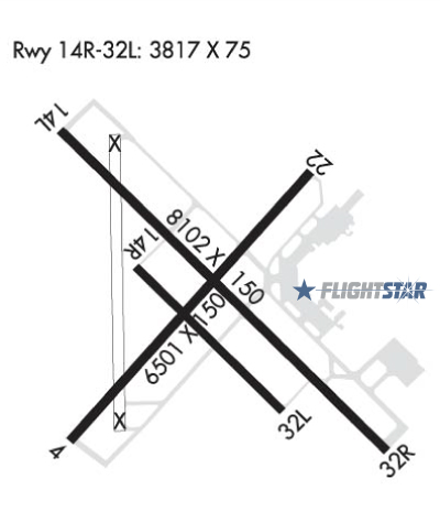
| Rwy | Rwy | |||||||
| 6502x150 | 6502' | 6502x150 | 6502' | |||||
| 8101x150 | 8101' | 8101x150 | 8101' | 109.10 - 318° | ||||
| 3816x75 | 3816' | 3816x75 | 3816' | |||||
| Runway ID | Single Wheel | Double Wheel | Double Tandem Wheel | Dual Double Wheel |
| 04/22 | 120,000 | 225,000 | 300,000 | N/A |
| 14L/32R | 100,000 | 180,000 | 260,000 | N/A |
| 14R/32L | 12,500 | 12,500 | N/A | N/A |
| These numbers are Advisory and are not limits. The Airport Manager should have more accurate Weight Limits | ||||
 Airport Diagram might not be current. | |
| Facility Name: | UNIVERSITY OF ILLINOIS/WILLARD |
| City Name: | CHAMPAIGN/URBANA |
| County: | CHAMPAIGN |
| State abbrev: | IL |
| State Name: | ILLINOIS |
| Ownership: | PUBLICLY OWNED |
| Use: | OPEN TO THE PUBLIC |
| Owner's Name: | UNIV OF ILLINOIS |
| Address: | 11 AIRPORT ROAD |
| SAVOY, IL 61874 | |
| Owner's Phone: | 217-244-8604 |
| Manager's Name: | TIMOTHY BANNON |
| Address: | 11 AIRPORT RD |
| SAVOY, IL 61874 | |
| Phone: | 217-244-8604 |
| FAA Region: | GREAT LAKES |
| FAA Field Office: | CHI |
| Date | Sunrise | Sunset |
|---|---|---|
| 04/17/24 Wednesday | 6:11 | 19:35 |
| 04/18/24 Thursday | 6:10 | 19:36 |
| 04/19/24 Friday | 6:08 | 19:37 |
| 04/20/24 Saturday | 6:07 | 19:38 |
| 04/21/24 Sunday | 6:05 | 19:39 |
| 04/22/24 Monday | 6:04 | 19:40 |
| 04/23/24 Tuesday | 6:03 | 19:41 |
| 04/24/24 Wednesday | 6:01 | 19:42 |
| 04/25/24 Thursday | 6:00 | 19:43 |
| 04/26/24 Friday | 5:59 | 19:44 |
| 04/27/24 Saturday | 5:57 | 19:45 |
| 04/28/24 Sunday | 5:56 | 19:46 |
| 04/29/24 Monday | 5:55 | 19:47 |
| 04/30/24 Tuesday | 5:53 | 19:48 |
| Airport Attendance Schedule | CONTINUOUS |
| Airport Status | OPERATIONAL (This Status can change at any time - please check NOTAMS) |
| Airport Lighting Schedule | ACTVT MALSR RWY 32R; MIRL RWY 04/22; HIRL RWY 14L/32R - CTAF. WHEN ATCT CLSD HIRL RWY 14L/32R PRESET ON LOW INTST, TO INCR INTST - CTAF. PAPI RWY 14L & 32R OPR CONSLY. |
| Airport Storage Available | Tie Downs |
| Extra Services Available | Avionics, Charter, Flight Instruction, Annual Surveying |
| Wind Indicator | YES - (lighted) |
| Control Tower | YES |
| CTAF Frequency | 120.400 |
| Unicom Frequency | 122.950 |
| Rotating Beacon Color | WG |
| Segmented Circle | NO |
| Landing Fee | NO |
| Airport Inspected | FEDERAL - performed by FAA AIRPORTS FIELD PERSONNEL |
| Inspection Date | 04/05/2023 |
| Type of Fuel Available | Grade 100LL, JET A-1 (icing inhibitor, freeze point -50C) |
| Airframe Repair Service | MAJOR |
| Power Plant Repair Service | MAJOR |
| Latitude | N4002.3 |
| Longitude | W08816.6 (ESTIMATED) |
| Arpt Elevation | 754ft (SURVEYED) |
| Magnetic Variation | 03W |
| 5 miles SW | of CHAMPAIGN/URBANA |
| Traffic Pattern Altitude | 750 |
| Sectional Chart | CHICAGO |
| Operations (Reported) | Yearly | Avg. Daily |
|---|---|---|
| General Aviation Transient | 10080 | 28 |
| General Aviation Local | 29737 | 81 |
| Air Taxi | 14035 | 38 |
| Commerical | 259 | 1 |
| Commuter | 0 | 0 |
| Military | 248 | 1 |
| Aircraft based on Field | |
|---|---|
| General Aviation Singles | 65 |
| General Aviation Multi | 4 |
| Jet Aircraft | 9 |
| General Aviation Helicopters | 0 |
| Military Aircraft | 0 |
| Gliders | 0 |
| Ultralights | 0 |
| FSS on field | NO |
| FSS tie-in | SAINT LOUIS |
| FSS Phone | 1-800-WX-BRIEF |
| Who issues Notams | CMI |
| Notam D service at airport | YES |
| ARTCC Name | CHICAGO |
| Airport Certification | AIRPORT RECEIVING SCHEDULED AIR CARRIER SERVICE FROM CARRIERS CERTIFICATED BY THE CIVIL AERONAUTICS BOARD; ARFF INDEX C AVBL ON REQ; 24 HR PPR CALL AMGR 217-333-5420. |
| Aircraft Rescue & Firefighting Index | AIRPORT HAS A CERTIFICATE UNDER CFR PART 139 |
| Airport of Entry | No |
| Custom Landing Rights | No; US CUSTOMS USER FEE ARPT. |
| Joint Civil/Military | No |
| Military Landing rights | YES |
| NATIONAL PLAN OF INTEGRATED AIRPORT SYSTEMS (NPIAS) |
| GRANT AGREEMENTS UNDER FAAP/ADAP/AIP |
| ASSURANCES PURSUANT TO TITLE VI, CIVIL RIGHTS ACT OF 1964 |
| AGREEMENT UNDER DLAND OR DCLA HAS EXPIRED. |
| TSNT PRKG ON SE GA APN ONLY. |
| RWY 14R/32L CLSD TO ACFT ABV 12500 LBS. |
| RWY 14R/32L CLSD 2300-0600. |
| U.S. CUSTOMS USER FEE ARPT: 2 HRS PPR CTC OFC ON 217-729-7607. |
| BIRDS ON & INVOF ARPT. |
| TWY A5 & C1 SW OF RWY 14L/32R CLSD TO ACFT OVR 11800 LBS. |
| TWY A6 & A7 ADJ TO AIR CARRIER APRON NOT VSB FM THE ATCT. |
| AER 22 & 32R NOT VSB FM EACH OTHER. |
| FOR CD IF UNA TO CTC ON FSS FREQ, CTC CHICAGO ARTCC AT 630-906-8921. |
| RWY 14R/ 32LRWY 14R/32L NOT AVBL FOR SKEDD ACR OPNS WITH MORE THAN 9 PSGR SEATS OR UNSCHEDULED ACR AT LEAST 31 PSGR SEATS. |
| RWY 32R CALM WIND RWY WHEN ATCT IS CLSD. |
Airport Communications & Frequencies:
| |||||||||||||||||||||||||||||||||||||||||||||||||||||
| Runway: 04 | Runway: 22 | ||
| Mag heading: | 44° | Mag heading: | 224° |
| Rwy Slope: | -.07% Down | Rwy Slope: | .07% Up |
| Approach: | Approach: | ||
| Pattern: | Left Traffic | Pattern: | Left Traffic |
| Markings: | NONPRECISION INSTRUMENT | Markings: | NONPRECISION INSTRUMENT |
| Marking Condition: | GOOD | Marking Condition: | GOOD |
| Arresting Dev: | Arresting Dev: | ||
| Lat & Long: | N4001.9 W08817.1 | Lat. & Long.: | N4002.7 W08816.2 |
| Elev: | 751.1 ft. MSL | Elev: | 746.4 ft. MSL |
| TCH: | TCH: | ||
| Visual Glide Path: | Visual Glide Path: | ||
| Displaced Threshold: | No | Displaced Threshold: | No |
| Touchdown Zone: | YES | Touchdown Zone: | YES |
| Touchdown Elev.: | 751.1 feet | Touchdown Elev.: | 749.6 feet |
| Visual Glide Slope: | Visual Glide Slope: | ||
| RVR Equipment: | RVR Equipment: | ||
| RVV Equipment: | NO | RVV Equipment: | NO |
| Approach Lights: | Approach Lights: | ||
| REIL: | NO | REIL: | NO |
| Centerline Lights: | NO | Centerline Lights: | NO |
| Touchdown lights: | NO | Touchdown lights: | NO |
| Runway Category: | Runway with a Non-precision Approach having visibility minimums greater than 3/4 mile | Runway Category: | Runway with a Non-precision Approach having visibility minimums greater than 3/4 mile |
| Declared Distances: | TORA:6502' TODA:6502' ASDA:6502' LDA:6502' | Declared Distances: | TORA:6502' TODA:6502' ASDA:6502' LDA:6502' |
| Obstructions: | Obstructions: | TREE | |
| Marked: | Marked: | NOT Marked/Lighted | |
| Clearance slope: | 50:1 | Clearance slope: | 28:1 |
| Obstruction height: | Obstruction height: | 53 feet AGL | |
| Dist. from runway: | Dist. from runway: | 1687 feet | |
| Centerline offset: | Centerline offset: | 279 feet left of centerline | |
| Comments: | Comments: |
| Runway: 14L | Runway: 32R | ||
| Mag heading: | 139° | Mag heading: | 319° |
| Rwy Slope: | -.07% Down | Rwy Slope: | .07% Up |
| Approach: | Approach: | ILS/DME | |
| Pattern: | Left Traffic | Pattern: | Left Traffic |
| Markings: | PRECISION INSTRUMENT | Markings: | PRECISION INSTRUMENT |
| Marking Condition: | FAIR | Marking Condition: | FAIR |
| Arresting Dev: | Arresting Dev: | ||
| Lat & Long: | N4002.8 W08817.1 | Lat. & Long.: | N4001.9 W08815.9 |
| Elev: | 754.9 ft. MSL | Elev: | 749.4 ft. MSL |
| TCH: | 48 ft. AGL | TCH: | 54 ft. AGL |
| Visual Glide Path: | 3.00 degrees | Visual Glide Path: | 3.00 degrees |
| Displaced Threshold: | No | Displaced Threshold: | No |
| Touchdown Zone: | YES | Touchdown Zone: | YES |
| Touchdown Elev.: | 754.9 feet | Touchdown Elev.: | 749.7 feet |
| Visual Glide Slope: | 4-Light PAPI on LEFT side of Runway | Visual Glide Slope: | 4-Light PAPI on LEFT side of Runway |
| RVR Equipment: | TOUCHDOWN-ROLLOUT | RVR Equipment: | TOUCHDOWN-ROLLOUT |
| RVV Equipment: | NO | RVV Equipment: | YES |
| Approach Lights: | Approach Lights: | MALSR - 1,400 foot medium intensity approach lighting system with runway alignment indicator lights | |
| REIL: | NO | REIL: | NO |
| Centerline Lights: | NO | Centerline Lights: | NO |
| Touchdown lights: | NO | Touchdown lights: | NO |
| Runway Category: | D | Runway Category: | Precision Instrument Runway |
| Declared Distances: | TORA:8101' TODA:8101' ASDA:8101' LDA:8101' | Declared Distances: | TORA:8101' TODA:8101' ASDA:8101' LDA:8101' |
| Runway: 14R | Runway: 32L | ||
| Mag heading: | 139° | Mag heading: | 319° |
| Rwy Slope: | -.18% Down | Rwy Slope: | .18% Up |
| Approach: | Approach: | ||
| Pattern: | Left Traffic | Pattern: | Left Traffic |
| Markings: | BASIC | Markings: | BASIC |
| Marking Condition: | FAIR | Marking Condition: | FAIR |
| Arresting Dev: | Arresting Dev: | ||
| Lat & Long: | N4002.4 W08816.9 | Lat. & Long.: | N4002.0 W08816.3 |
| Elev: | 750.1 ft. MSL | Elev: | 743.1 ft. MSL |
| TCH: | 36 ft. AGL | TCH: | 35 ft. AGL |
| Visual Glide Path: | 3.00 degrees | Visual Glide Path: | 3.00 degrees |
| Displaced Threshold: | No | Displaced Threshold: | No |
| Touchdown Zone: | YES | Touchdown Zone: | YES |
| Touchdown Elev.: | 750.2 feet | Touchdown Elev.: | 749.4 feet |
| Visual Glide Slope: | 4-Light PAPI on LEFT side of Runway | Visual Glide Slope: | 4-Light PAPI on LEFT side of Runway |
| RVR Equipment: | RVR Equipment: | ||
| RVV Equipment: | NO | RVV Equipment: | NO |
| Approach Lights: | Approach Lights: | ||
| REIL: | NO | REIL: | NO |
| Centerline Lights: | NO | Centerline Lights: | NO |
| Touchdown lights: | NO | Touchdown lights: | NO |
| Runway Category: | Runway with a Visual Approach | Runway Category: | Runway with a Visual Approach |
| Declared Distances: | TORA:3816' TODA:3816' ASDA:3816' LDA:3816' | Declared Distances: | TORA:3816' TODA:3816' ASDA:3816' LDA:3816' |
Thanks for using FltPlan.com
all rights reserved © 1999-2024 by Flight Plan LLC