
| ARCATA AIRPORT ARCATA/EUREKA CA |
| |
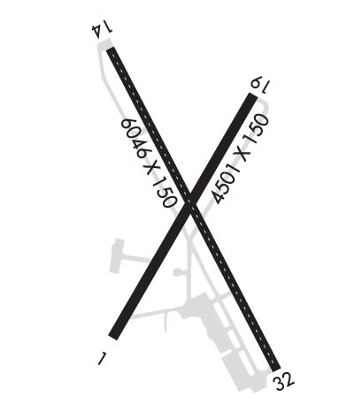
| Lat: N 4058.7 Long: W 12406.5 Elev: 222 Var: -17 Longest Runway: 6046 | ||
| AWOS: 118.52 CTAF: 123.0 | ||
| ||||||||||||||||||||||||||||||||||||||||||||
| ||||||||||||||||||||||||||||||||||||||||||||
| ||||||||||||||||||||||||||||||||||||||||||||
| Rwy | Rwy | |||||||
| 4501x150 | 4501' | 4501x150 | 4501' | |||||
| 6046x150 | 5801' | 6046x150 | 5846' | 109.50 - 315° | ||||
| Runway ID | Single Wheel | Double Wheel | Double Tandem Wheel | Dual Double Wheel |
| 01/19 | 60,000 | 95,000 | 170,000 | N/A |
| 14/32 | 60,000 | 155,000 | 280,000 | N/A |
| These numbers are Advisory and are not limits. The Airport Manager should have more accurate Weight Limits | ||||
 Airport Diagram might not be current. | |
| Facility Name: | CALIFORNIA REDWOOD COAST-HUMBOLDT COUNTY |
| City Name: | ARCATA/EUREKA |
| County: | HUMBOLDT |
| State abbrev: | CA |
| State Name: | CALIFORNIA |
| Ownership: | PUBLICLY OWNED |
| Use: | OPEN TO THE PUBLIC |
| Owner's Name: | HUMBOLDT COUNTY |
| Address: | 1106 SECOND ST |
| EUREKA, CA 95501 | |
| Owner's Phone: | (707) 496-0102 |
| Manager's Name: | RYAN COOLEY; EMAIL: RCOOLEY@CO.HUMBOLDT.CA.US |
| Address: | 3561 BOEING AVE. |
| MCKINLEYVILLE, CA 95519 | |
| Phone: | 707-839-5401 |
| FAA Region: | WESTERN-PACIFIC |
| FAA Field Office: | SFO |
| Date | Sunrise | Sunset |
|---|---|---|
| 07/17/25 Thursday | 5:59 | 20:46 |
| 07/18/25 Friday | 6:00 | 20:45 |
| 07/19/25 Saturday | 6:00 | 20:45 |
| 07/20/25 Sunday | 6:01 | 20:44 |
| 07/21/25 Monday | 6:02 | 20:43 |
| 07/22/25 Tuesday | 6:03 | 20:42 |
| 07/23/25 Wednesday | 6:04 | 20:41 |
| 07/24/25 Thursday | 6:05 | 20:41 |
| 07/25/25 Friday | 6:06 | 20:40 |
| 07/26/25 Saturday | 6:07 | 20:39 |
| 07/27/25 Sunday | 6:08 | 20:38 |
| 07/28/25 Monday | 6:08 | 20:37 |
| 07/29/25 Tuesday | 6:09 | 20:36 |
| 07/30/25 Wednesday | 6:10 | 20:35 |
| Airport Attendance Schedule | ALL 0400-2359 |
| Airport Status | OPERATIONAL (This Status can change at any time - please check NOTAMS) |
| Airport Lighting Schedule | ACTVT MALSR RWY 32; TDZL RWY 32; C/L LGTS RWY 14 & 32; REIL RWY 14; PAPI RWY 14 & 32; HIRL RWY 14/32 - CTAF. MIRL RWY 01/19, REIL RWY 01, AND VASI RWY 01 PPR CTC 707-382-2551 OR 707-496-0102. |
| Airport Storage Available | Tie Downs |
| Extra Services Available | Cargo Handling |
| Wind Indicator | YES - (lighted) |
| Control Tower | NO |
| CTAF Frequency | 123.000 |
| Unicom Frequency | 123.000 |
| Rotating Beacon Color | WG |
| Segmented Circle | YES |
| Landing Fee | YES; LNDG FEE: CTC ARPT OR CHECK ARPT WEBSITE FOR DTLS, EXEMPTIONS. |
| Airport Inspected | FEDERAL - performed by FAA AIRPORTS FIELD PERSONNEL |
| Inspection Date | 06/28/2024 |
| Type of Fuel Available | Grade 100LL, JET A (freeze point -40C); -10FUEL AVBL 0400-2400 LOCAL, AND AFTER HOURS WITH ADVANCED NOTICE. |
| Airframe Repair Service | NONE |
| Power Plant Repair Service | NONE |
| Latitude | N4058.7 |
| Longitude | W12406.5 (ESTIMATED) |
| Arpt Elevation | 222ft (SURVEYED) |
| Magnetic Variation | 17E |
| 7 miles N | of ARCATA/EUREKA |
| Traffic Pattern Altitude | |
| Sectional Chart | KLAMATH FALLS |
| Operations (Reported) | Yearly | Avg. Daily |
|---|---|---|
| General Aviation Transient | 0 | 0 |
| General Aviation Local | 0 | 0 |
| Air Taxi | 0 | 0 |
| Commerical | 0 | 0 |
| Commuter | 0 | 0 |
| Military | 0 | 0 |
| Aircraft based on Field | |
|---|---|
| General Aviation Singles | 0 |
| General Aviation Multi | 0 |
| Jet Aircraft | 0 |
| General Aviation Helicopters | 0 |
| Military Aircraft | 0 |
| Gliders | 0 |
| Ultralights | 0 |
| FSS on field | NO |
| FSS tie-in | OAKLAND |
| FSS Phone | 1-800-WX-BRIEF |
| Who issues Notams | ACV |
| Notam D service at airport | YES |
| ARTCC Name | SEATTLE |
| Airport Certification | AIRPORT RECEIVING SCHEDULED AIR CARRIER SERVICE FROM CARRIERS CERTIFICATED BY THE CIVIL AERONAUTICS BOARD; RWY 1/19 NOT AVBL FOR SKED ACR OPNS WITH MORE THAN 9 PSGR SEATS OR UNSKED ACR AT LEAST 31 PSGR SEATS. |
| Aircraft Rescue & Firefighting Index | AIRPORT HAS A CERTIFICATE UNDER CFR PART 139 |
| Airport of Entry | No |
| Custom Landing Rights | No |
| Joint Civil/Military | No |
| Military Landing rights | YES |
| NATIONAL PLAN OF INTEGRATED AIRPORT SYSTEMS (NPIAS) |
| GRANT AGREEMENTS UNDER FAAP/ADAP/AIP |
| SURPLUS PROPERTY AGREEMENT UNDER PUBLIC LAW 289 |
| ASSURANCES PURSUANT TO TITLE VI, CIVIL RIGHTS ACT OF 1964 |
| FOR CD IF UNA TO CTC ON FSS FREQ, CTC SEATTLE ARTCC AT 253-351-3694. |
| RWY 01/1 9 PCR VALUE: 62/F/D/X/U |
| RWY 14/3 2 PCR VALUE: 530/F/D/X/T |
Airport Communications & Frequencies:
| |||||||||
| Runway: 01 | Runway: 19 | ||
| Mag heading: | 13° | Mag heading: | 193° |
| Rwy Slope: | .46% Up | Rwy Slope: | -.46% Down |
| Approach: | Approach: | ||
| Pattern: | Left Traffic | Pattern: | Right Traffic |
| Markings: | NONPRECISION INSTRUMENT | Markings: | NONPRECISION INSTRUMENT |
| Marking Condition: | FAIR | Marking Condition: | FAIR |
| Arresting Dev: | Arresting Dev: | ||
| Lat & Long: | N4058.3 W12406.8 | Lat. & Long.: | N4059.0 W12406.3 |
| Elev: | 187.4 ft. MSL | Elev: | 208.3 ft. MSL |
| TCH: | 48 ft. AGL | TCH: | |
| Visual Glide Path: | 3.00 degrees | Visual Glide Path: | |
| Displaced Threshold: | No | Displaced Threshold: | No |
| Touchdown Zone: | YES | Touchdown Zone: | YES |
| Touchdown Elev.: | 203.8 feet | Touchdown Elev.: | 208.3 feet |
| Visual Glide Slope: | 4-BOX VASI ON LEFT SIDE OF RUNWAY | Visual Glide Slope: | |
| RVR Equipment: | RVR Equipment: | ||
| RVV Equipment: | NO | RVV Equipment: | NO |
| Approach Lights: | Approach Lights: | ||
| REIL: | YES | REIL: | NO |
| Centerline Lights: | NO | Centerline Lights: | NO |
| Touchdown lights: | NO | Touchdown lights: | NO |
| Runway Category: | Runway with a Non-precision Approach having visibility minimums greater than 3/4 mile | Runway Category: | Runway with a Visual Approach |
| Declared Distances: | TORA:4501' TODA:4501' ASDA:4501' LDA:4501' | Declared Distances: | TORA:4501' TODA:4501' ASDA:4501' LDA:4501' |
| Obstructions: | Obstructions: | TREES | |
| Marked: | Marked: | NOT Marked/Lighted | |
| Clearance slope: | Clearance slope: | 23:1 | |
| Obstruction height: | Obstruction height: | 142 feet AGL | |
| Dist. from runway: | Dist. from runway: | 3450 feet | |
| Centerline offset: | Centerline offset: | ||
| Comments: | Comments: |
| Runway: 14 | Runway: 32 | ||
| Mag heading: | 136° | Mag heading: | 316° |
| Rwy Slope: | .65% Up | Rwy Slope: | -.65% Down |
| Approach: | Approach: | ILS/DME | |
| Pattern: | Right Traffic | Pattern: | Left Traffic |
| Markings: | PRECISION INSTRUMENT | Markings: | PRECISION INSTRUMENT |
| Marking Condition: | GOOD | Marking Condition: | GOOD |
| Arresting Dev: | Arresting Dev: | EMAS; ENGINEERED MATERIAL ARRESTING SYSTEM (EMAS) 280 FT IN LEN BY 170 FT IN WID STARTING 70 FT BYD DER 32. | |
| Lat & Long: | N4059.1 W12406.8 | Lat. & Long.: | N4058.2 W12406.2 |
| Elev: | 182.9 ft. MSL | Elev: | 222.3 ft. MSL |
| TCH: | 50 ft. AGL | TCH: | 43 ft. AGL |
| Visual Glide Path: | 3.00 degrees | Visual Glide Path: | 3.00 degrees |
| Displaced Threshold: | 245 feet | Displaced Threshold: | 200 feet |
| Touchdown Zone: | YES | Touchdown Zone: | YES |
| Touchdown Elev.: | 205.1 feet | Touchdown Elev.: | 221.4 feet |
| Visual Glide Slope: | 4-Light PAPI on LEFT side of Runway | Visual Glide Slope: | 4-Light PAPI on LEFT side of Runway |
| RVR Equipment: | TOUCHDOWN-ROLLOUT | RVR Equipment: | TOUCHDOWN-ROLLOUT |
| RVV Equipment: | NO | RVV Equipment: | NO |
| Approach Lights: | Approach Lights: | MALSR - 1,400 foot medium intensity approach lighting system with runway alignment indicator lights | |
| REIL: | YES | REIL: | NO |
| Centerline Lights: | YES | Centerline Lights: | YES |
| Touchdown lights: | NO | Touchdown lights: | YES |
| Runway Category: | Runway with a Non-precision Approach having visibility minimums greater than 3/4 mile | Runway Category: | Precision Instrument Runway |
| Declared Distances: | TORA:6046' TODA:6046' ASDA:5846' LDA:5601' | Declared Distances: | TORA:6046' TODA:6046' ASDA:6046' LDA:5846' |
| Obstructions: | Obstructions: | TREE | |
| Marked: | Marked: | NOT Marked/Lighted | |
| Clearance slope: | 50:1 | Clearance slope: | 26:1 |
| Obstruction height: | Obstruction height: | 91 feet AGL | |
| Dist. from runway: | Dist. from runway: | 2625 feet | |
| Centerline offset: | Centerline offset: | 875 feet right of centerline | |
| Comments: | Comments: |
Thanks for using FltPlan.com
all rights reserved © 1999-2025 by Flight Plan LLC
