
| CRYSTAL LAKE DECATUR AR |
| |
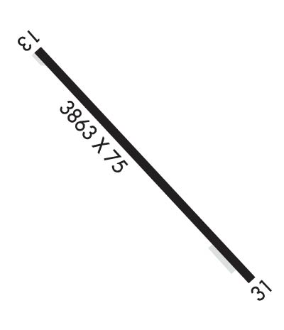
| Lat: N 3620.6 Long: W 09426.7 Elev: 1178 Var: -03 Longest Runway: 3863 | ||
| Clr Del: 126.6 CTAF: 122.8 | ||
| ||||||||||||||||||||||||||||||||
| ||||||||||||||||||||||||||||||||
| Rwy | Rwy | |||||||
| 3863x75 | 3863' | 3863x75 | 3863' | |||||
| Runway ID | Single Wheel | Double Wheel | Double Tandem Wheel | Dual Double Wheel |
| 13/31 | 10,000 | N/A | N/A | N/A |
| These numbers are Advisory and are not limits. The Airport Manager should have more accurate Weight Limits | ||||
 Airport Diagram might not be current. | |
| Facility Name: | CRYSTAL LAKE |
| City Name: | DECATUR |
| County: | BENTON |
| State abbrev: | AR |
| State Name: | ARKANSAS |
| Ownership: | PRIVATELY OWNED |
| Use: | OPEN TO THE PUBLIC |
| Owner's Name: | CRYSTAL LAKE FLY-IN COMMUNITY, LLC |
| Address: | 33801 KANIS ROAD |
| PARON, AR 72122 | |
| Owner's Phone: | 501-351-4545 |
| Manager's Name: | LANCE DIXON |
| Address: | 18820 CRYSTAL LAKE ROAD |
| DECATUR, AR 72722 | |
| Phone: | 479-220-5047 |
| FAA Region: | SOUTHWEST |
| FAA Field Office: | AOK |
| Date | Sunrise | Sunset |
|---|---|---|
| 07/17/25 Thursday | 6:13 | 20:35 |
| 07/18/25 Friday | 6:14 | 20:34 |
| 07/19/25 Saturday | 6:14 | 20:33 |
| 07/20/25 Sunday | 6:15 | 20:33 |
| 07/21/25 Monday | 6:16 | 20:32 |
| 07/22/25 Tuesday | 6:16 | 20:32 |
| 07/23/25 Wednesday | 6:17 | 20:31 |
| 07/24/25 Thursday | 6:18 | 20:30 |
| 07/25/25 Friday | 6:19 | 20:29 |
| 07/26/25 Saturday | 6:19 | 20:29 |
| 07/27/25 Sunday | 6:20 | 20:28 |
| 07/28/25 Monday | 6:21 | 20:27 |
| 07/29/25 Tuesday | 6:22 | 20:26 |
| 07/30/25 Wednesday | 6:23 | 20:25 |
| Airport Attendance Schedule | UNATTENDED |
| Airport Status | OPERATIONAL (This Status can change at any time - please check NOTAMS) |
| Airport Lighting Schedule | SS-SR |
| Airport Storage Available | Tie Downs, Hanger |
| Extra Services Available | Flight Instruction |
| Wind Indicator | YES - (lighted) |
| Control Tower | NO |
| CTAF Frequency | 122.800 |
| Unicom Frequency | 122.800 |
| Rotating Beacon Color | |
| Segmented Circle | NO |
| Landing Fee | NO |
| Airport Inspected | STATE - performed by STATE AERONAUTICAL PERSONNEL |
| Inspection Date | 07/10/2023 |
| Type of Fuel Available | None |
| Airframe Repair Service | MAJOR |
| Power Plant Repair Service | MAJOR |
| Latitude | N3620.6 |
| Longitude | W09426.7 (ESTIMATED) |
| Arpt Elevation | 1177ft (SURVEYED) |
| Magnetic Variation | 03E |
| 2 miles NE | of DECATUR |
| Traffic Pattern Altitude | |
| Sectional Chart | KANSAS CITY |
| Operations (Reported) | Yearly | Avg. Daily |
|---|---|---|
| General Aviation Transient | 0 | 0 |
| General Aviation Local | 0 | 0 |
| Air Taxi | 0 | 0 |
| Commerical | 0 | 0 |
| Commuter | 0 | 0 |
| Military | 0 | 0 |
| Aircraft based on Field | |
|---|---|
| General Aviation Singles | 0 |
| General Aviation Multi | 0 |
| Jet Aircraft | 0 |
| General Aviation Helicopters | 0 |
| Military Aircraft | 0 |
| Gliders | 0 |
| Ultralights | 0 |
| FSS on field | NO |
| FSS tie-in | JONESBORO |
| FSS Phone | 1-800-WX-BRIEF |
| Who issues Notams | JBR |
| Notam D service at airport | YES |
| ARTCC Name | MEMPHIS |
| Airport Certification | |
| Aircraft Rescue & Firefighting Index | None |
| Airport of Entry | No |
| Custom Landing Rights | No |
| Joint Civil/Military | No |
| Military Landing rights | No |
| BE ALERT FOR +176 FT TWR APRXLY 1300 FT N OF RY 13. |
| DEER & GEESE ON & INVOF ARPT. |
| FOR CD CTC RAZORBACK APCH 479-649-2416, WHEN APCH CLSD CTC MEMPHIS ARTCC AT 901-368-8453/8449. |
Airport Communications & Frequencies:
| |||||||||||||||||||
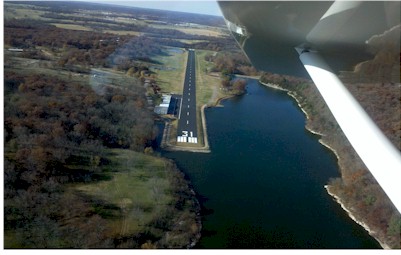
| Runway: 13 | Runway: 31 | ||
| Mag heading: | 131° | Mag heading: | 311° |
| Rwy Slope: | .58% Up | Rwy Slope: | -.58% Down |
| Approach: | Approach: | ||
| Pattern: | Left Traffic | Pattern: | Left Traffic |
| Markings: | NONPRECISION INSTRUMENT | Markings: | NONPRECISION INSTRUMENT |
| Marking Condition: | FAIR; NSTD THLD MARKINGS DUE TO SIZE. | Marking Condition: | FAIR; NSTD THLD MARKNIGS DUE TO SIZE. |
| Arresting Dev: | Arresting Dev: | ||
| Lat & Long: | N3620.8 W09427.0 | Lat. & Long.: | N3620.4 W09426.4 |
| Elev: | 1154.0 ft. MSL | Elev: | 1176.4 ft. MSL |
| TCH: | TCH: | ||
| Visual Glide Path: | Visual Glide Path: | ||
| Displaced Threshold: | No | Displaced Threshold: | No |
| Touchdown Zone: | YES | Touchdown Zone: | YES |
| Touchdown Elev.: | 1177.7 feet | Touchdown Elev.: | 1177.8 feet |
| Visual Glide Slope: | Visual Glide Slope: | ||
| RVR Equipment: | RVR Equipment: | ||
| RVV Equipment: | NO | RVV Equipment: | NO |
| Approach Lights: | Approach Lights: | ||
| REIL: | NO | REIL: | NO |
| Centerline Lights: | NO | Centerline Lights: | NO |
| Touchdown lights: | NO | Touchdown lights: | NO |
| Runway Category: | Runway with a Non-precision Approach | Runway Category: | Runway with a Visual Approach |
| Declared Distances: | Declared Distances: | ||
| Obstructions: | TREES | Obstructions: | TREES |
| Marked: | NOT Marked/Lighted | Marked: | NOT Marked/Lighted |
| Clearance slope: | 4:1 | Clearance slope: | 2:1 |
| Obstruction height: | 55 feet AGL | Obstruction height: | 41 feet AGL |
| Dist. from runway: | 450 feet | Dist. from runway: | 300 feet |
| Centerline offset: | 185 right of centerline | Centerline offset: | 125 feet left of centerline |
| Comments: | Comments: |
Thanks for using FltPlan.com
all rights reserved © 1999-2025 by Flight Plan LLC