
| CECIL COUNTY ELKTON MD |
| |
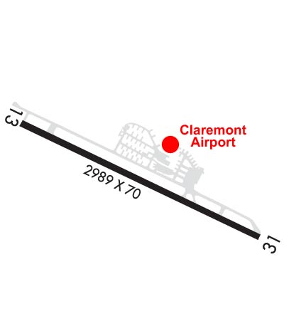
| Lat: N 3934.5 Long: W 07552.2 Elev: 106 Var: +12 Longest Runway: 2989 | ||
| CTAF: 122.8 | ||
| ||||||
|
| Rwy | Rwy | |||||||
| 2989x70 | 2701' | 2989x70 | 2388' | |||||
| Runway ID | Single Wheel | Double Wheel | Double Tandem Wheel | Dual Double Wheel |
| 13/31 | N/A | N/A | N/A | N/A |
| These numbers are Advisory and are not limits. The Airport Manager should have more accurate Weight Limits | ||||
 Airport Diagram might not be current. | |
| Facility Name: | CLAREMONT |
| City Name: | ELKTON |
| County: | CECIL |
| State abbrev: | MD |
| State Name: | MARYLAND |
| Ownership: | PRIVATELY OWNED |
| Use: | OPEN TO THE PUBLIC |
| Owner's Name: | CJ FLIGHT CLA LLC; CJ FLIGHT CLA LLC DBA CLAREMONT AIRPORT. |
| Address: | P.O. BOX 445 |
| ELKTON, MD 21922 | |
| Owner's Phone: | (410) 398-0234 |
| Manager's Name: | MARY HALL |
| Address: | P.O. BOX 445 |
| ELKTON, MD 21922 | |
| Phone: | (410) 398-0234 |
| FAA Region: | EASTERN |
| FAA Field Office: | DCA |
| Date | Sunrise | Sunset |
|---|---|---|
| 07/17/25 Thursday | 5:50 | 20:29 |
| 07/18/25 Friday | 5:51 | 20:28 |
| 07/19/25 Saturday | 5:51 | 20:28 |
| 07/20/25 Sunday | 5:52 | 20:27 |
| 07/21/25 Monday | 5:53 | 20:26 |
| 07/22/25 Tuesday | 5:54 | 20:26 |
| 07/23/25 Wednesday | 5:55 | 20:25 |
| 07/24/25 Thursday | 5:56 | 20:24 |
| 07/25/25 Friday | 5:56 | 20:23 |
| 07/26/25 Saturday | 5:57 | 20:22 |
| 07/27/25 Sunday | 5:58 | 20:21 |
| 07/28/25 Monday | 5:59 | 20:20 |
| 07/29/25 Tuesday | 6:00 | 20:19 |
| 07/30/25 Wednesday | 6:01 | 20:18 |
| Airport Attendance Schedule | 7 Days A Week 0900-1600 |
| Airport Status | OPERATIONAL (This Status can change at any time - please check NOTAMS) |
| Airport Lighting Schedule | ACTVT REIL RWY 13 & 31; PAPI RWY 13 & 31; MIRL RWY 13/31 - 123.0.; ACTVT ROTG BCN - 123.0. |
| Airport Storage Available | Tie Downs |
| Extra Services Available | Avionics |
| Wind Indicator | YES - (lighted) |
| Control Tower | NO |
| CTAF Frequency | 122.800 |
| Unicom Frequency | 122.800 |
| Rotating Beacon Color | WG |
| Segmented Circle | NO |
| Landing Fee | NO |
| Airport Inspected | STATE - performed by STATE AERONAUTICAL PERSONNEL |
| Inspection Date | 03/07/2025 |
| Type of Fuel Available | Grade 100LL; -10SELF SERVE. |
| Airframe Repair Service | MINOR |
| Power Plant Repair Service | MINOR |
| Latitude | N3934.5 |
| Longitude | W07552.2 (ESTIMATED) |
| Arpt Elevation | 106ft (SURVEYED) |
| Magnetic Variation | 12W |
| 3 miles SW | of ELKTON |
| Traffic Pattern Altitude | |
| Sectional Chart | WASHINGTON |
| Operations (Reported) | Yearly | Avg. Daily |
|---|---|---|
| General Aviation Transient | 0 | 0 |
| General Aviation Local | 0 | 0 |
| Air Taxi | 0 | 0 |
| Commerical | 0 | 0 |
| Commuter | 0 | 0 |
| Military | 0 | 0 |
| Aircraft based on Field | |
|---|---|
| General Aviation Singles | 0 |
| General Aviation Multi | 0 |
| Jet Aircraft | 0 |
| General Aviation Helicopters | 0 |
| Military Aircraft | 0 |
| Gliders | 0 |
| Ultralights | 0 |
| FSS on field | NO |
| FSS tie-in | LEESBURG |
| FSS Phone | 1-800-WX-BRIEF |
| Who issues Notams | DCA |
| Notam D service at airport | YES |
| ARTCC Name | NEW YORK |
| Airport Certification | |
| Aircraft Rescue & Firefighting Index | None |
| Airport of Entry | No |
| Custom Landing Rights | No |
| Joint Civil/Military | No |
| Military Landing rights | No |
| DEER & BIRDS ON & INVOF ARPT. |
| REDUCED BRAKING ACTION RWY 13 DOWNHILL 1.5 DEG. |
| CALM/LIGHT WIND USE RWY 31. |
| FOR CD CTC PHILADELPHIA APCH AT (800) 354-9884. |
| RWY 13/3 1 RWY 13/31 NO TGL. |
| RWY 13/3 1 UNFILLED CRACKS, ALLIGATOR CRACKING, LATERAL & LONGL CRACKING, VEG GROWTH, OXIDATION. |
Airport Communications & Frequencies:
| |||||||||||||||||
| Runway: 13 | Runway: 31 | ||
| Mag heading: | 128° | Mag heading: | 308° |
| Rwy Slope: | -1.48% Down | Rwy Slope: | 1.48% Up |
| Approach: | Approach: | ||
| Pattern: | Left Traffic | Pattern: | Left Traffic |
| Markings: | BASIC | Markings: | NONPRECISION INSTRUMENT |
| Marking Condition: | FAIR; FADED. | Marking Condition: | FAIR; FADED. |
| Arresting Dev: | Arresting Dev: | ||
| Lat & Long: | N3934.6 W07552.5 | Lat. & Long.: | N3934.3 W07551.9 |
| Elev: | 106.4 ft. MSL | Elev: | 62.2 ft. MSL |
| TCH: | 6 ft. AGL | TCH: | 6 ft. AGL |
| Visual Glide Path: | 5.00 degrees | Visual Glide Path: | 4.00 degrees |
| Displaced Threshold: | 288 feet | Displaced Threshold: | 601 feet |
| Touchdown Zone: | YES | Touchdown Zone: | YES |
| Touchdown Elev.: | 101.4 feet | Touchdown Elev.: | 106.4 feet |
| Visual Glide Slope: | 2-Light PAPI on RIGHT side of Runway | Visual Glide Slope: | 2-Light PAPI on LEFT side of Runway |
| RVR Equipment: | RVR Equipment: | ||
| RVV Equipment: | NO | RVV Equipment: | NO |
| Approach Lights: | Approach Lights: | ||
| REIL: | YES | REIL: | YES |
| Centerline Lights: | NO | Centerline Lights: | NO |
| Touchdown lights: | NO | Touchdown lights: | NO |
| Runway Category: | Runway with a Visual Approach | Runway Category: | Runway with a Visual Approach |
| Declared Distances: | Declared Distances: | ||
| Obstructions: | TREES | Obstructions: | TREES |
| Marked: | NOT Marked/Lighted | Marked: | NOT Marked/Lighted |
| Clearance slope: | 12:1; APCH SLOPE 20:1 TO DSPLCD THR AT CNTRLN. | Clearance slope: | 2:1; APCH SLOPE 20:1 TO DSPLCD THR AT CNTRLN. |
| Obstruction height: | 49 feet AGL | Obstruction height: | 102 feet AGL |
| Dist. from runway: | 803 feet | Dist. from runway: | 476 feet |
| Centerline offset: | 28 left of centerline | Centerline offset: | 110 feet right of centerline |
| Comments: | Comments: | PLINE, MKD 10 FT, 40 FT FM THR. TREES 35 FT, 145 FT FM THR. |
Thanks for using FltPlan.com
all rights reserved © 1999-2025 by Flight Plan LLC
