| ROSECRANS MEMORIAL ST JOSEPH MO |
| |
| Lat: N 3946.3 Long: W 09454.6 Elev: 827 Var: -04 Longest Runway: 8061 | ||
| Dept. ATIS: 125.05 Arr. ATIS: 125.05 AWOS: 125.05 Ground: 121.9 Tower: 126.9 | ||
| |||||||||||||||||||||||||||||||||||||||||||||||||||||||||||||
| |||||||||||||||||||||||||||||||||||||||||||||||||||||||||||||
| |||||||||||||||||||||||||||||||||||||||||||||||||||||||||||||
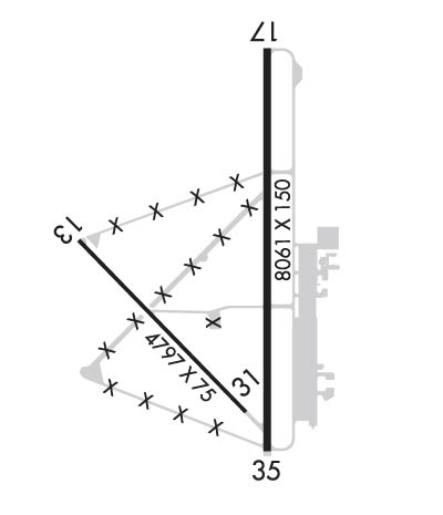
| Rwy | Rwy | |||||||
| 4797x75 | 4797' | 4797x75 | 4797' | |||||
| 8061x150 | 8061' | 8061x150 | 8061' | 110.30 - 356° | ||||
| Runway ID | Single Wheel | Double Wheel | Double Tandem Wheel | Dual Double Wheel |
| 13/31 | 75,000 | 110,000 | 180,000 | 180,000 |
| 17/35 | 75,000 | 130,000 | 220,000 | 220,000 |
| These numbers are Advisory and are not limits. The Airport Manager should have more accurate Weight Limits | ||||
 Airport Diagram might not be current. | |
| Facility Name: | ROSECRANS MEML |
| City Name: | ST JOSEPH |
| County: | BUCHANAN |
| State abbrev: | MO |
| State Name: | MISSOURI |
| Ownership: | PUBLICLY OWNED |
| Use: | OPEN TO THE PUBLIC |
| Owner's Name: | CITY OF ST JOSEPH |
| Address: | 11TH & FREDERICK |
| ST JOSEPH, MO 64501 | |
| Owner's Phone: | 816-271-4653 |
| Manager's Name: | ABRAHAM J. FORNEY |
| Address: | 100B NW ROSECRANS DR |
| ST JOSEPH, MO 64503 | |
| Phone: | 816-271-5374 |
| FAA Region: | CENTRAL |
| FAA Field Office: | NONE |
| Date | Sunrise | Sunset |
|---|---|---|
| 09/24/21 Friday | 7:09 | 19:14 |
| 09/25/21 Saturday | 7:10 | 19:12 |
| 09/26/21 Sunday | 7:11 | 19:10 |
| 09/27/21 Monday | 7:12 | 19:09 |
| 09/28/21 Tuesday | 7:13 | 19:07 |
| 09/29/21 Wednesday | 7:14 | 19:06 |
| 09/30/21 Thursday | 7:15 | 19:04 |
| 10/01/21 Friday | 7:16 | 19:02 |
| 10/02/21 Saturday | 7:17 | 19:01 |
| 10/03/21 Sunday | 7:18 | 18:59 |
| 10/04/21 Monday | 7:19 | 18:58 |
| 10/05/21 Tuesday | 7:20 | 18:56 |
| 10/06/21 Wednesday | 7:21 | 18:54 |
| 10/07/21 Thursday | 7:22 | 18:53 |
| Airport Attendance Schedule | 7 Days A Week 0700-1900; FOR SVCS AFT HRS CALL 816-271-3450 OR 816-262-4919. |
| Airport Status | OPERATIONAL (This Status can change at any time - please check NOTAMS) |
| Airport Lighting Schedule | HIRL RWY 17/35 PRESET ON LOW INTST; TO INCR INTST; ACTVT MIRL RWY 13/31 AND REIL RWYS 17/35 - CTAF. |
| Airport Storage Available | Tie Downs, Hanger |
| Extra Services Available | Air Freight, Crop Dusting, Avionics, Charter, Flight Instruction, Aircraft Rental, Aircraft Sales, Annual Surveying |
| Wind Indicator | YES - (lighted) |
| Control Tower | YES |
| CTAF Frequency | 126.900 |
| Unicom Frequency | 122.950 |
| Rotating Beacon Color | CLEAR-GREEN (Light Land Airport) |
| Segmented Circle | YES |
| Landing Fee | NO |
| Airport Inspected | STATE - performed by FAA AIRPORTS FIELD PERSONNEL |
| Inspection Date | 04/19/2021 |
| Type of Fuel Available | Grade 100LL, JET A (freeze point -40C) |
| Airframe Repair Service | MAJOR |
| Power Plant Repair Service | MAJOR |
| Latitude | N3946.3 |
| Longitude | W09454.6 (ESTIMATED) |
| Arpt Elevation | 826ft (SURVEYED) |
| Magnetic Variation | 04E |
| 3 miles NW | of ST JOSEPH |
| Traffic Pattern Altitude | |
| Sectional Chart | KANSAS CITY |
| Operations (Reported) | Yearly | Avg. Daily |
|---|---|---|
| General Aviation Transient | 6105 | 17 |
| General Aviation Local | 4678 | 13 |
| Air Taxi | 292 | 1 |
| Commerical | 0 | 0 |
| Commuter | 0 | 0 |
| Military | 6816 | 19 |
| Aircraft based on Field | |
|---|---|
| General Aviation Singles | 39 |
| General Aviation Multi | 3 |
| Jet Aircraft | 4 |
| General Aviation Helicopters | 3 |
| Military Aircraft | 10 |
| Gliders | 0 |
| Ultralights | 0 |
| FSS on field | NO |
| FSS tie-in | COLUMBIA |
| FSS Phone | 1-800-WX-BRIEF |
| Who issues Notams | STJ |
| Notam D service at airport | YES |
| ARTCC Name | KANSAS CITY |
| Airport Certification | RWY 13/31 NOT AVBL FOR SCHEDULED ACR OPNS WITH MORE THAN 9 PSGR SEATS OR UNSCHEDULED ACR AT LEAST 31 PSGR SEATS |
| Aircraft Rescue & Firefighting Index | AIRPORT HAS A CERTIFICATE UNDER CFR PART 139 |
| Airport of Entry | No |
| Custom Landing Rights | No |
| Joint Civil/Military | No |
| Military Landing rights | YES |
| NATIONAL PLAN OF INTEGRATED AIRPORT SYSTEMS (NPIAS) |
| GRANT AGREEMENTS UNDER FAAP/ADAP/AIP |
| SURPLUS PROPERTY AGREEMENT UNDER PUBLIC LAW 289 |
| ASSURANCES PURSUANT TO TITLE VI, CIVIL RIGHTS ACT OF 1964 |
| FOR ADVY & POSITION INFO CALL STJ ATCT OR MONTR ATCT FREQ WHEN CLSD. |
| CAUTION: AFLD SUR BY LAKES AND MISSOURI RIVER. MODERATE SMALL BIRD ACT MID-NOV THRU MID-MAR AND MAY THRU AUG AND INCREASED BIRD ACTIVITY MID-MAR THRU APR AND SEP THRU MID-NOV. INTS ANG TACTICAL TRNG WITHIN ARPT TFC AREA. |
| FUEL - A++ (MIL). |
| AIRFIELD CONDITIONS ARE NOT MONITORED BETWEEN THE HOURS OF 1530L-0700L |
| ANG: OPR 1200-2200Z++ TUE-FRI, EXC HOL. PPR RQR FOR FULL STOP ONLY AND VALID +/- 30 MIN. TRAN ALERT SVC AND FAC AVBL 1230-2230Z++ TUE-FRI, OT BY PRIOR APVL ONLY. NO TRAN ALERT MAINT AVBL, NON-C130 CREW MUST BE PRESENT FOR REFUEL. LTD FUEL OPS. EXTREMELY LTD PRK. 139 AW BASE OPS DSN 356-3596/3260, C816- 236-3596/3260. IF NO ANSWER CTC COMD POST DSN 356-3224/3225, C816-236-3224/3225. RCR AVBL DUR DUTY HR DSN 356-3260 |
| ANG: CREWS ATNDG AATTC COURSES CTC BRADY OPS 349.15. |
| ANG: CSTMS 1200-2200++ TUE-FRI. AFT HRS ARR MUST BE SKED 48 HRS IN ADVN BY FONE DURG RGLR BUS HRS, CTC AFLD MGMT AT C816-236-3596. INSP NOT ALWAYS AVBL AFT HRS AND WKENDS. |
| ARPT CLSD TO ACFT OVR 350000 LBS EXCEPT PPR. |
| FOR CD IF UNA TO CTC ON FSS FREQ, CTC KANSAS CITY APCH AT 816-329-2710. |
| ANG: MODERATE SMALL BIRD ACT POSSIBLE SR TO SS. BASH II PERIOD (1 OCT-15 APR). MIL ACFT SEE AP/1 ENTRY FOR DETAILED BASH INFO. |
| ARFF AVBL BY ANG. |
| HIGH MIGRATORY BIRD ACTIVITY OCT THRU MAR ON & INVOF ARPT. |
| RWY 13/3 1 RWY 13-31 HAS ASSAULT STRIP PANELS THAT ARE CERISE AND ORANGE IN COLOR. |
| RWY 17/3 5 CENTER 130 FT GROOVED. |
Airport Communications & Frequencies:
| |||||||||||||||||||||||||||||||||||||
| Runway: 13 | Runway: 31 | ||
| Mag heading: | 132° | Mag heading: | 312° |
| Rwy Slope: | .00% Up | Rwy Slope: | .00% Down |
| Approach: | Approach: | ||
| Pattern: | Left Traffic | Pattern: | Left Traffic |
| Markings: | NONPRECISION INSTRUMENT | Markings: | NONPRECISION INSTRUMENT |
| Marking Condition: | GOOD | Marking Condition: | GOOD |
| Arresting Dev: | Arresting Dev: | ||
| Lat & Long: | N3946.4 W09455.2 | Lat. & Long.: | N3945.9 W09454.5 |
| Elev: | 811.3 ft. MSL | Elev: | 811.5 ft. MSL |
| TCH: | 40 ft. AGL | TCH: | 40 ft. AGL |
| Visual Glide Path: | 3.00 degrees | Visual Glide Path: | 3.00 degrees |
| Displaced Threshold: | No | Displaced Threshold: | No |
| Touchdown Zone: | YES | Touchdown Zone: | YES |
| Touchdown Elev.: | 811.4 feet | Touchdown Elev.: | 811.5 feet |
| Visual Glide Slope: | 4-Light PAPI on LEFT side of Runway | Visual Glide Slope: | 4-Light PAPI on LEFT side of Runway |
| RVR Equipment: | RVR Equipment: | ||
| RVV Equipment: | NO | RVV Equipment: | NO |
| Approach Lights: | Approach Lights: | ||
| REIL: | NO | REIL: | NO |
| Centerline Lights: | NO | Centerline Lights: | NO |
| Touchdown lights: | NO | Touchdown lights: | NO |
| Runway Category: | Runway with a Non-precision Approach having visibility minimums greater than 3/4 mile | Runway Category: | Runway with a Non-precision Approach having visibility minimums greater than 3/4 mile |
| Declared Distances: | TORA:4797' TODA:4797' ASDA:4797' LDA:4797' | Declared Distances: | TORA:4797' TODA:4797' ASDA:4797' LDA:4797' |
| Runway: 17 | Runway: 35 | ||
| Mag heading: | 176° | Mag heading: | 356° |
| Rwy Slope: | -.18% Down | Rwy Slope: | .18% Up |
| Approach: | Approach: | ILS | |
| Pattern: | Left Traffic | Pattern: | Left Traffic |
| Markings: | PRECISION INSTRUMENT | Markings: | PRECISION INSTRUMENT |
| Marking Condition: | FAIR | Marking Condition: | FAIR |
| Arresting Dev: | Arresting Dev: | ||
| Lat & Long: | N3947.1 W09454.4 | Lat. & Long.: | N3945.7 W09454.4 |
| Elev: | 826.5 ft. MSL | Elev: | 812.1 ft. MSL |
| TCH: | 56 ft. AGL | TCH: | 64 ft. AGL |
| Visual Glide Path: | 3.00 degrees | Visual Glide Path: | 2.80 degrees |
| Displaced Threshold: | No | Displaced Threshold: | No |
| Touchdown Zone: | YES | Touchdown Zone: | YES |
| Touchdown Elev.: | 826.5 feet | Touchdown Elev.: | 814.7 feet |
| Visual Glide Slope: | 4-BOX VASI ON LEFT SIDE OF RUNWAY | Visual Glide Slope: | 4-BOX VASI ON LEFT SIDE OF RUNWAY |
| RVR Equipment: | ROLLOUT | RVR Equipment: | TOUCHDOWN |
| RVV Equipment: | NO | RVV Equipment: | YES |
| Approach Lights: | Approach Lights: | ||
| REIL: | YES | REIL: | YES |
| Centerline Lights: | NO | Centerline Lights: | NO |
| Touchdown lights: | NO | Touchdown lights: | NO |
| Runway Category: | Runway with a Non-precision Approach having visibility minimums greater than 3/4 mile | Runway Category: | Precision Instrument Runway |
| Declared Distances: | TORA:8061' TODA:8061' ASDA:8061' LDA:8061' | Declared Distances: | TORA:8061' TODA:8061' ASDA:8061' LDA:8061' |
Thanks for using FltPlan.com
all rights reserved © 1999-2021 by Flight Plan LLC