
| PORTLAND INTL PORTLAND OR |
| |
| Lat: N 4535.3 Long: W 12235.8 Elev: 31 Var: -16 Longest Runway: 11000 | ||
| Clr Del: 120.12 Dept. ATIS: 128.35 Arr. ATIS: 128.35 Ground: 121.9/132.27 Tower: 118.7/ 123.77 | ||
| |||||||||||||||||||||||||||||||||||||||||||||||||||||||||||||
| |||||||||||||||||||||||||||||||||||||||||||||||||||||||||||||
| |||||||||||||||||||||||||||||||||||||||||||||||||||||||||||||
| Rwy | Rwy | |||||||
| 6000x150 | 6000' | 6000x150 | 6000' | 108.90 - 209° | ||||
| 9825x150 | 8535' | 111.30 - 103° | 9825x150 | 9290' | 111.30 - 283° | |||
| 11000x150 | 11000' | 110.50 - 103° | 11000x150 | 11000' | 110.50 - 283° | |||
| Runway ID | Single Wheel | Double Wheel | Double Tandem Wheel | Dual Double Wheel |
| 03/21 | 120,000 | 250,000 | 380,000 | N/A |
| 10L/28R | 200,000 | 200,000 | 400,000 | N/A |
| 10R/28L | 200,000 | 200,000 | 360,000 | N/A |
| These numbers are Advisory and are not limits. The Airport Manager should have more accurate Weight Limits | ||||
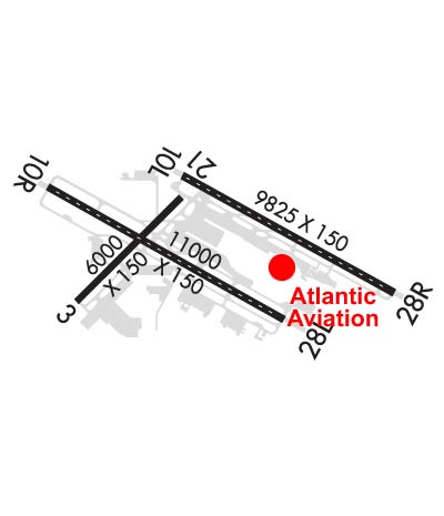 Airport Diagram might not be current. | |
| Facility Name: | PORTLAND INTL |
| City Name: | PORTLAND |
| County: | MULTNOMAH |
| State abbrev: | OR |
| State Name: | OREGON |
| Ownership: | PUBLICLY OWNED |
| Use: | OPEN TO THE PUBLIC |
| Owner's Name: | THE PORT OF PORTLAND |
| Address: | BOX 3529 |
| PORTLAND, OR 97208 | |
| Owner's Phone: | 503-415-6000 |
| Manager's Name: | STEPHEN NAGY; ARPT OPS GENERAL MGR |
| Address: | 7200 NE AIRPORT WAY |
| PORTLAND, OR 97218 | |
| Phone: | 503-415-6195 |
| FAA Region: | NORTHWEST MOUNTAIN |
| FAA Field Office: | SEA |

| Date | Sunrise | Sunset |
|---|---|---|
| 09/24/21 Friday | 7:00 | 19:04 |
| 09/25/21 Saturday | 7:01 | 19:02 |
| 09/26/21 Sunday | 7:02 | 19:00 |
| 09/27/21 Monday | 7:03 | 18:59 |
| 09/28/21 Tuesday | 7:05 | 18:57 |
| 09/29/21 Wednesday | 7:06 | 18:55 |
| 09/30/21 Thursday | 7:07 | 18:53 |
| 10/01/21 Friday | 7:08 | 18:51 |
| 10/02/21 Saturday | 7:10 | 18:49 |
| 10/03/21 Sunday | 7:11 | 18:47 |
| 10/04/21 Monday | 7:12 | 18:45 |
| 10/05/21 Tuesday | 7:14 | 18:43 |
| 10/06/21 Wednesday | 7:15 | 18:41 |
| 10/07/21 Thursday | 7:16 | 18:40 |
| Airport Attendance Schedule | CONTINUOUS |
| Airport Status | OPERATIONAL (This Status can change at any time - please check NOTAMS) |
| Airport Lighting Schedule | SS-SR |
| Airport Storage Available | Tie Downs, Hanger |
| Extra Services Available | Air Freight, Air Ambulance, Avionics, Cargo Handling, Charter, Flight Instruction, Aircraft Rental, Aircraft Sales |
| Wind Indicator | YES - (lighted) |
| Control Tower | YES |
| CTAF Frequency | |
| Unicom Frequency | 122.950 |
| Rotating Beacon Color | CLEAR-GREEN (Light Land Airport) |
| Segmented Circle | NO |
| Landing Fee | YES; COMMERCIAL ACFT & OPERATORS OF ACFT WITH AN FAA CERTIFIED MAX GROSS LANDING WEIGHT THAT EXCEEDS 10000 LBS ARE REQUIRED TO PAY A LANDING FEE. |
| Airport Inspected | FEDERAL - performed by FAA AIRPORTS FIELD PERSONNEL |
| Inspection Date | 08/22/2019 |
| Type of Fuel Available | Grade 100LL, JET A (freeze point -40C) |
| Airframe Repair Service | MAJOR |
| Power Plant Repair Service | MAJOR |
| Latitude | N4535.3 |
| Longitude | W12235.8 (ESTIMATED) |
| Arpt Elevation | 30ft (SURVEYED) |
| Magnetic Variation | 16E |
| 4 miles NE | of PORTLAND |
| Traffic Pattern Altitude | |
| Sectional Chart | SEATTLE |
| Operations (Reported) | Yearly | Avg. Daily |
|---|---|---|
| General Aviation Transient | 6874 | 19 |
| General Aviation Local | 3517 | 10 |
| Air Taxi | 16168 | 44 |
| Commerical | 113737 | 312 |
| Commuter | 0 | 0 |
| Military | 2212 | 6 |
| Aircraft based on Field | |
|---|---|
| General Aviation Singles | 16 |
| General Aviation Multi | 39 |
| Jet Aircraft | 19 |
| General Aviation Helicopters | 1 |
| Military Aircraft | 21 |
| Gliders | 0 |
| Ultralights | 0 |
| FSS on field | NO |
| FSS tie-in | MC MINNVILLE |
| FSS Phone | 1-800-WX-BRIEF |
| Who issues Notams | PDX |
| Notam D service at airport | YES |
| ARTCC Name | SEATTLE |
| Airport Certification | AIRPORT RECEIVING SCHEDULED AIR CARRIER SERVICE FROM CARRIERS CERTIFICATED BY THE CIVIL AERONAUTICS BOARD |
| Aircraft Rescue & Firefighting Index | AIRPORT HAS A CERTIFICATE UNDER CFR PART 139 |
| Airport of Entry | No |
| Custom Landing Rights | YES |
| Joint Civil/Military | No |
| Military Landing rights | YES |
| NATIONAL PLAN OF INTEGRATED AIRPORT SYSTEMS (NPIAS) |
| GRANT AGREEMENTS UNDER FAAP/ADAP/AIP |
| SURPLUS PROPERTY AGREEMENT UNDER PUBLIC LAW 289 |
| ASSURANCES PURSUANT TO TITLE VI, CIVIL RIGHTS ACT OF 1964 |
| UNCONTROLLED TFC AT PEARSON FIELD VANCOUVER WA 3 NM W OF RY 10L THLD ON EXTDD CNTRLN. |
| (E94) WSFO/WSO/FW/RFC. |
| AREA OF TWY T BTN M & E3 NOT VSB FM TWR. |
| ACFT AUTHORIZED TO UTILIZE THE NORTHWEST RAMP WILL BE TOWED TO/FROM THIS RAMP. |
| AT THE WEST END ARM/DEARM AREA ON TWY C NO ACFT OF ANY TYPE MAY TAXI PAST THE ARM/DEARM AREA WHILE IT IS BEING USED. |
| ARPT CLSD TO NON-POWERED ACFT EXCP IN EMERG. |
| BEARING STRENGTH: RWY 03-21 ST 175, RY 10L-28R ST175, RY 10R-28L ST175. |
| JASU - 4(A/M32A-86) (MC-11) 1(MA-1A). |
| FUEL - A (AIR BP - ATLANTIC AVIATION SVCS. C503-331-4220) J8(MIL) (NC-100LL, A) |
| FLUID - LHOXRB. |
| OIL - O-128-133-148(MIL). |
| MISC: FLT NOTIFICATION SVC, ADCUS, AVBL. |
| ANG : PPR/OFFL BUS ONLY. BASE OPS OPR 1500-2300Z++ MON-FRI EXC HOL.; DSN 638-4390, C503-335-4390. CTC BASE OPS 15 MIN PRIOR TO LDG AND AFTER DEP ON 281.2. TRAN QUARTERS NOT AVBL. CAUTION: OBST LIGHTING IS NOT NVD COMPATIBLE. NVD NOT AUTHORIZED WHILE AIRBORNE IN VCNTY OF AFLD. |
| TWY V CLSD TO ACFT WITH WINGSPAN GREATER THAN 168 FT. ACFT WITH WINGSPAN GREATER THAN 118 FT PROHIBITED FM TURNING WB ONTO TWY A FM TWY V UNLESS UNDER TOW. |
| ANG: SEE FLIP AP/1 FOR SUPPLEMENTARY ARPT INFO. HAZARDOUS BIRD COND EXIST. PHASE 1 MAY-OCT, PHASE II NOV-APR. CURRENT BIRD WATCH CONDITIONS ARE NOT REPORTED ON ATIS. |
| TWY W CLSD TO ACFT WITH WINGSPAN GTR THAN 118 FT UNLESS UNDER TOW. |
| TWY T BTN EXITS B5 & B6 CLSD TO ACFT WITH WINGSPAN GTR THAN 118 FT. |
| NSTD YELLOW PRK SPOT DESIGNATORS AND EQPT TOOL BOX LCTN PAINTED ON RAMP. PLEASE CTC BASE OPS OR REQ FOLLOW ME IF NOT FAMILIAR WITH PANGB PRK PROCEDURES. |
| TWY C3 CLSD TO ACFT WITH WINGSPAN EQUAL TO OR GTR THAN 79 FT. |
| PDX HAS FAC CONSTRAINTS THAT LMT ITS ABILITY TO ACCOMMODATE DIVD FLTS & MNTN THE ARPT SAFE OPN DUR IREG OPS. ACFT OPRS SHUD CTC THE ARPT DUTY MGR AT (503) 460-4236 TO COORD DIVD FLTS EXC IN THE CASE OF A DECLARED IN-FLT EMERG. |
| ACFT WITH WINGSPAN GREATER THAN 118 FEET ARE PROHIBITED FROM TURNING EASTBOUND ON TWY C FROM SOUTHWESTBOUND ON TWY F UNLESS UNDER TOW. |
| TWY A3 BTN TWY A & THE GA RAMP CLSD TO ACFT WITH WINGSPAN GTR THAN 135 FEET UNLESS UNDER TOW. |
| TWY E3 CLSD TO ACFT WITH WINGSPAN GTR THAN 198 FEET. |
| TWY T BTN TWY E3 & TWY B5 CLSD TO ACFT WITH WINGSPAN GTR THAN 198 FT. |
| TWY C BTN TWY C6 AND TWY C8 CLSD TO ACFT WITH WINGSPAN GTR THAN 180 FEET. |
| ASSC IN USE. OPERATE TRANSPONDERS WITH ALTITUDE REPORTING MODE AND ADS-B (IF EQUIPPED) ENABLED ON ALL AIRPORT SURFACES. |
| TWY K BTN TWY A5 & TWY V CLSD TO ACFT WINGSPAN MORE THAN 168 FT. |
| MIGRATORY & WINTERING FLOCKS OF LRG WATERFOWL ON & INVOF APRT. HEAVY SEAGULL ACTIVITY SEP THRU APR; EXPECT HIGH NMBR OF BIRDS YEAR AROUND; CK LCL ADVISORIES. |
| TWY M BTN TWY E & TWY T CLSD TO ACFT WINGSPAN MORE THAN 118 FT. |
| TWY T BTN TWY E2 & TWY E3 CLSD TO ACFT WINGSPAN MORE THAN 118 FT. |
| TWY K BTN TWY V & TWY A4 CLSD TO ACFT WINGSPAN MORE THAN 118 FT. |
| NOISE ABATEMENT PROCEDURES IN EFFECT; CALL NOISE OFFICE AT 503-460-4100. RY 28L ARRIVALS ARE NOISE SENSITIVE, EXPECT APCH TO 28R WITH TRANSITION TO 28L. |
| 180 DEGREE TURNS BY ACFT WEIGHING IN EXCESS OF 12500 LBS PROHIBITED ON RY 10L/28R, RY 03/21 AND ALL TWYS. |
| RWY 03/2 1 RY 21 CLSD TO HEIGHT GROUP IV ACFT WITH COCKPIT TO WHEEL HEIGHT GREATER THAN 22 FT. |
Airport Communications & Frequencies:
| |||||||||||||||||||||||||||||||||||||||||||||||||||||||||||||||||
| Runway: 03 | Runway: 21 | ||
| Mag heading: | 29° | Mag heading: | 209° |
| Rwy Slope: | .07% Up | Rwy Slope: | -.07% Down |
| Approach: | Approach: | LOC/DME | |
| Pattern: | Left Traffic | Pattern: | Left Traffic |
| Markings: | NONPRECISION INSTRUMENT | Markings: | NONPRECISION INSTRUMENT |
| Marking Condition: | GOOD | Marking Condition: | GOOD |
| Arresting Dev: | Arresting Dev: | ||
| Lat & Long: | N4534.9 W12237.0 | Lat. & Long.: | N4535.6 W12236.0 |
| Elev: | 22.2 ft. MSL | Elev: | 26.4 ft. MSL |
| TCH: | 60 ft. AGL | TCH: | 32 ft. AGL |
| Visual Glide Path: | 3.30 degrees | Visual Glide Path: | 3.60 degrees |
| Displaced Threshold: | No | Displaced Threshold: | No |
| Touchdown Zone: | YES | Touchdown Zone: | YES |
| Touchdown Elev.: | 22.9 feet | Touchdown Elev.: | 26.4 feet |
| Visual Glide Slope: | 4-Light PAPI on LEFT side of Runway; PDX RWY 03 PAPI UNUSABLE BYND 4 DEG LEFT AND RIGHT OF RCL AND BEYOND 5 NM UNUSABLE | Visual Glide Slope: | 4-Light PAPI on RIGHT side of Runway |
| RVR Equipment: | RVR Equipment: | ||
| RVV Equipment: | NO | RVV Equipment: | NO |
| Approach Lights: | Approach Lights: | ||
| REIL: | YES | REIL: | YES |
| Centerline Lights: | NO | Centerline Lights: | NO |
| Touchdown lights: | NO | Touchdown lights: | NO |
| Runway Category: | Runway with a Visual Approach | Runway Category: | Runway with a Non-precision Approach having visibility minimums greater than 3/4 mile |
| Declared Distances: | TORA:6000' TODA:6000' ASDA:6000' LDA:6000' | Declared Distances: | TORA:6000' TODA:6000' ASDA:6000' LDA:6000' |
| Obstructions: | Obstructions: | ROAD | |
| Marked: | Marked: | NOT Marked/Lighted | |
| Clearance slope: | 34:1 | Clearance slope: | 14:1 |
| Obstruction height: | Obstruction height: | 19 feet AGL | |
| Dist. from runway: | Dist. from runway: | 475 feet | |
| Centerline offset: | Centerline offset: | ||
| Comments: | Comments: |
| Runway: 10L | Runway: 28R | ||
| Mag heading: | 103° | Mag heading: | 283° |
| Rwy Slope: | .01% Up | Rwy Slope: | -.01% Down |
| Approach: | ILS/DME | Approach: | ILS/DME |
| Pattern: | Left Traffic | Pattern: | Right Traffic |
| Markings: | PRECISION INSTRUMENT | Markings: | PRECISION INSTRUMENT |
| Marking Condition: | GOOD | Marking Condition: | GOOD |
| Arresting Dev: | Arresting Dev: | ||
| Lat & Long: | N4535.8 W12236.0 | Lat. & Long.: | N4535.0 W12234.0 |
| Elev: | 29.5 ft. MSL | Elev: | 30.8 ft. MSL |
| TCH: | 51 ft. AGL | TCH: | 70 ft. AGL |
| Visual Glide Path: | 3.00 degrees | Visual Glide Path: | 3.00 degrees |
| Displaced Threshold: | 1290 feet | Displaced Threshold: | 535 feet |
| Touchdown Zone: | YES | Touchdown Zone: | YES |
| Touchdown Elev.: | 30.2 feet | Touchdown Elev.: | 30.8 feet |
| Visual Glide Slope: | 4-Light PAPI on LEFT side of Runway | Visual Glide Slope: | 4-Light PAPI on RIGHT side of Runway |
| RVR Equipment: | TOUCHDOWN-MIDFIELD-ROLLOUT | RVR Equipment: | TOUCHDOWN-MIDFIELD-ROLLOUT |
| RVV Equipment: | NO | RVV Equipment: | NO |
| Approach Lights: | MALSR - 1,400 foot medium intensity approach lighting system with runway alignment indicator lights | Approach Lights: | MALSR - 1,400 foot medium intensity approach lighting system with runway alignment indicator lights |
| REIL: | NO | REIL: | NO |
| Centerline Lights: | YES | Centerline Lights: | YES |
| Touchdown lights: | NO | Touchdown lights: | NO |
| Runway Category: | Precision Instrument Runway | Runway Category: | Precision Instrument Runway |
| Declared Distances: | TORA:9825' TODA:9825' ASDA:9825' LDA:8535' | Declared Distances: | TORA:9825' TODA:9825' ASDA:9825' LDA:9290' |
| Obstructions: | Obstructions: | ROAD; RWY 28R PERIMETER ROAD AT 200 FT FM RWY THLD AND 408' RIGHT FM RWY EXTNDD CNTRLN. | |
| Marked: | Marked: | NOT Marked/Lighted | |
| Clearance slope: | 50:1 | Clearance slope: | |
| Obstruction height: | Obstruction height: | 32 feet AGL | |
| Dist. from runway: | Dist. from runway: | 200 feet | |
| Centerline offset: | Centerline offset: | 408 feet right of centerline | |
| Comments: | Comments: | RWY 28R 60' LEVEE ROAD LCTD APRXLY PARALLEL TO RWY AT 200' FM THR AND 507' RT FM RWY EXTNDD CNTRLN. |
| Runway: 10R | Runway: 28L | ||
| Mag heading: | 103° | Mag heading: | 283° |
| Rwy Slope: | .00% | Rwy Slope: | .00% |
| Approach: | ILS/DME | Approach: | ILS/DME |
| Pattern: | Right Traffic | Pattern: | Left Traffic |
| Markings: | PRECISION INSTRUMENT | Markings: | PRECISION INSTRUMENT |
| Marking Condition: | GOOD | Marking Condition: | GOOD |
| Arresting Dev: | BAK-12B; TYPE-H BAK-12B(B) (1625'). | Arresting Dev: | BAK-12B; TYPE-H BAK-12B(B) (2000'). |
| Lat & Long: | N4535.7 W12237.3 | Lat. & Long.: | N4534.8 W12235.0 |
| Elev: | 22.7 ft. MSL | Elev: | 22.7 ft. MSL |
| TCH: | 71 ft. AGL | TCH: | 72 ft. AGL |
| Visual Glide Path: | 3.00 degrees | Visual Glide Path: | 3.00 degrees |
| Displaced Threshold: | No | Displaced Threshold: | No |
| Touchdown Zone: | YES | Touchdown Zone: | YES |
| Touchdown Elev.: | 23.7 feet | Touchdown Elev.: | 22.7 feet |
| Visual Glide Slope: | 4-Light PAPI on RIGHT side of Runway | Visual Glide Slope: | 4-Light PAPI on LEFT side of Runway; POSSIBLE RWY 28L GLIDESLOPE FLUCTUATION PRIOR TO ADDUM WHEN WEATHER IS GREATER THAN 800/2. |
| RVR Equipment: | TOUCHDOWN-MIDFIELD-ROLLOUT | RVR Equipment: | TOUCHDOWN-MIDFIELD-ROLLOUT |
| RVV Equipment: | NO | RVV Equipment: | NO |
| Approach Lights: | ALSF2 - standard 2,400 foot high intensity approach lighting system with sequenced flashers, Category II or III | Approach Lights: | MALSR - 1,400 foot medium intensity approach lighting system with runway alignment indicator lights |
| REIL: | NO | REIL: | NO |
| Centerline Lights: | YES | Centerline Lights: | YES |
| Touchdown lights: | YES | Touchdown lights: | NO |
| Runway Category: | Precision Instrument Runway | Runway Category: | Precision Instrument Runway |
| Declared Distances: | TORA:11000' TODA:11000' ASDA:11000' LDA:11000' | Declared Distances: | TORA:11000' TODA:11000' ASDA:11000' LDA:11000' |
Thanks for using FltPlan.com
all rights reserved © 1999-2021 by Flight Plan LLC
