
| SAGINAW COUNTY H.W. BROWNE SAGINAW MI |
| |
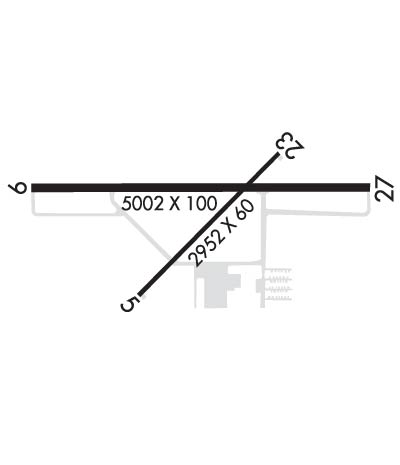
| Lat: N 4326.0 Long: W 08351.7 Elev: 602 Var: +07 Longest Runway: 5002 | ||
| AWOS: 118.32 CTAF: 122.8 | ||
| ||||||||||||||||||||||||||||||||||||||||||||
| ||||||||||||||||||||||||||||||||||||||||||||
| ||||||||||||||||||||||||||||||||||||||||||||
| Rwy | Rwy | |||||||
| 2952x60 | 2833' | 2952x60 | 2823' | |||||
| 5002x100 | 5002' | 5002x100 | 5002' | 111.35 - 276° | ||||
| Runway ID | Single Wheel | Double Wheel | Double Tandem Wheel | Dual Double Wheel |
| 05/23 | 12,500 | N/A | N/A | N/A |
| 10/28 | 60,000 | 72,000 | 101,000 | N/A |
| These numbers are Advisory and are not limits. The Airport Manager should have more accurate Weight Limits | ||||
 Airport Diagram might not be current. | |
| Facility Name: | SAGINAW COUNTY/H W BROWNE |
| City Name: | SAGINAW |
| County: | SAGINAW |
| State abbrev: | MI |
| State Name: | MICHIGAN |
| Ownership: | PUBLICLY OWNED |
| Use: | OPEN TO THE PUBLIC |
| Owner's Name: | COUNTY OF SAGINAW |
| Address: | 4821 JANES RD |
| SAGINAW, MI 48601-9656 | |
| Owner's Phone: | 989-758-2459 |
| Manager's Name: | ALAN KAUFMAN |
| Address: | 4789 JANES RD |
| SAGINAW, MI 48601 | |
| Phone: | 989-295-0675 |
| FAA Region: | GREAT LAKES |
| FAA Field Office: | DET |

| Date | Sunrise | Sunset |
|---|---|---|
| 06/27/26 Saturday | 5:57 | 21:20 |
| 06/28/26 Sunday | 5:57 | 21:20 |
| 06/29/26 Monday | 5:57 | 21:20 |
| 06/30/26 Tuesday | 5:58 | 21:20 |
| 07/01/26 Wednesday | 5:58 | 21:20 |
| 07/02/26 Thursday | 5:59 | 21:20 |
| 07/03/26 Friday | 5:59 | 21:20 |
| 07/04/26 Saturday | 6:00 | 21:19 |
| 07/05/26 Sunday | 6:01 | 21:19 |
| 07/06/26 Monday | 6:01 | 21:19 |
| 07/07/26 Tuesday | 6:02 | 21:18 |
| 07/08/26 Wednesday | 6:03 | 21:18 |
| 07/09/26 Thursday | 6:03 | 21:17 |
| 07/10/26 Friday | 6:04 | 21:17 |
| Airport Attendance Schedule | MON-FRI 0730-1700, SAT-SUN 0800-1200; UNATNDD MAJOR HOLS. |
| Airport Status | OPERATIONAL (This Status can change at any time - please check NOTAMS) |
| Airport Lighting Schedule | ACTVT MALSF RWY 28; REIL RWY 10; PAPI RWY 05, 23, 10, & 28; HIRL RWY 10/28; MIRL RWY 05/23 - CTAF. PAPI RWY 10 & 28 OPR CONSLY DURG DALGT HRS. |
| Airport Storage Available | Tie Downs |
| Extra Services Available | Flight Instruction, Aircraft Rental |
| Wind Indicator | YES - (lighted) |
| Control Tower | NO |
| CTAF Frequency | 122.800 |
| Unicom Frequency | 122.800 |
| Rotating Beacon Color | WG |
| Segmented Circle | NO |
| Landing Fee | NO |
| Airport Inspected | STATE - performed by STATE AERONAUTICAL PERSONNEL |
| Inspection Date | 09/17/2025 |
| Type of Fuel Available | Grade 100LL, JET A; -10100LL & JET A+ AVBL H24 SELF SVC. |
| Airframe Repair Service | MAJOR |
| Power Plant Repair Service | MAJOR |
| Latitude | N4326.0 |
| Longitude | W08351.7 (ESTIMATED) |
| Arpt Elevation | 601ft (SURVEYED) |
| Magnetic Variation | 07W |
| 4 miles E | of SAGINAW |
| Traffic Pattern Altitude | |
| Sectional Chart | DETROIT |
| Operations (Reported) | Yearly | Avg. Daily |
|---|---|---|
| General Aviation Transient | 0 | 0 |
| General Aviation Local | 0 | 0 |
| Air Taxi | 0 | 0 |
| Commerical | 0 | 0 |
| Commuter | 0 | 0 |
| Military | 0 | 0 |
| Aircraft based on Field | |
|---|---|
| General Aviation Singles | 0 |
| General Aviation Multi | 0 |
| Jet Aircraft | 0 |
| General Aviation Helicopters | 0 |
| Military Aircraft | 0 |
| Gliders | 0 |
| Ultralights | 0 |
| FSS on field | NO |
| FSS tie-in | LANSING |
| FSS Phone | 1-800-WX-BRIEF |
| Who issues Notams | HYX |
| Notam D service at airport | YES |
| ARTCC Name | CLEVELAND |
| Airport Certification | |
| Aircraft Rescue & Firefighting Index | None |
| Airport of Entry | No |
| Custom Landing Rights | No |
| Joint Civil/Military | No |
| Military Landing rights | YES |
| NATIONAL PLAN OF INTEGRATED AIRPORT SYSTEMS (NPIAS) |
| GRANT AGREEMENTS UNDER FAAP/ADAP/AIP |
| ASSURANCES PURSUANT TO TITLE VI, CIVIL RIGHTS ACT OF 1964 |
| DEER & LRG BIRDS ON & INVOF ARPT. |
| FOR CD CTC GREAT LAKES APCH AT 269-459-3345, WHEN APCH CLSD CTC CLEVELAND ARTCC AT 440-774-0224/0490. |
Airport Communications & Frequencies:
| |||||||||||||||||
| Runway: 05 | Runway: 23 | ||
| Mag heading: | 52° | Mag heading: | 232° |
| Rwy Slope: | -.10% Down | Rwy Slope: | .10% Up |
| Approach: | Approach: | ||
| Pattern: | Left Traffic | Pattern: | Left Traffic |
| Markings: | BASIC | Markings: | BASIC |
| Marking Condition: | GOOD | Marking Condition: | GOOD |
| Arresting Dev: | Arresting Dev: | ||
| Lat & Long: | N4325.8 W08352.0 | Lat. & Long.: | N4326.1 W08351.5 |
| Elev: | 600.8 ft. MSL | Elev: | 597.9 ft. MSL |
| TCH: | 25 ft. AGL | TCH: | 25 ft. AGL |
| Visual Glide Path: | 3.00 degrees | Visual Glide Path: | 3.00 degrees |
| Displaced Threshold: | 119 feet | Displaced Threshold: | 129 feet |
| Touchdown Zone: | YES | Touchdown Zone: | YES |
| Touchdown Elev.: | 601.5 feet | Touchdown Elev.: | 601.5 feet |
| Visual Glide Slope: | 2-Light PAPI on LEFT side of Runway | Visual Glide Slope: | 2-Light PAPI on RIGHT side of Runway |
| RVR Equipment: | RVR Equipment: | ||
| RVV Equipment: | NO | RVV Equipment: | NO |
| Approach Lights: | Approach Lights: | ||
| REIL: | NO | REIL: | NO |
| Centerline Lights: | NO | Centerline Lights: | NO |
| Touchdown lights: | NO | Touchdown lights: | NO |
| Runway Category: | Runway with a Visual Approach | Runway Category: | Runway with a Visual Approach |
| Declared Distances: | Declared Distances: | ||
| Obstructions: | FENCE | Obstructions: | ROAD |
| Marked: | NOT Marked/Lighted | Marked: | NOT Marked/Lighted |
| Clearance slope: | 1:1; APCH RATIO 20:1 TO DTHR. | Clearance slope: | 1:1; APCH RATIO 20:1 TO DTHR. |
| Obstruction height: | 6 feet AGL | Obstruction height: | 15 feet AGL |
| Dist. from runway: | 200 feet | Dist. from runway: | 210 feet |
| Centerline offset: | 120 right of centerline | Centerline offset: | 126 feet right of centerline |
| Comments: | Comments: | 2 FT CONC CULVERT, 100 FT DIST, 80 FT L; -15 FT DITCH, ACRS APCH END. |
| Runway: 10 | Runway: 28 | ||
| Mag heading: | 97° | Mag heading: | 277° |
| Rwy Slope: | -.03% Down | Rwy Slope: | .03% Up |
| Approach: | Approach: | ILS/DME | |
| Pattern: | Left Traffic | Pattern: | Left Traffic |
| Markings: | NONPRECISION INSTRUMENT | Markings: | PRECISION INSTRUMENT |
| Marking Condition: | GOOD | Marking Condition: | GOOD |
| Arresting Dev: | Arresting Dev: | ||
| Lat & Long: | N4326.0 W08352.3 | Lat. & Long.: | N4326.0 W08351.2 |
| Elev: | 598.7 ft. MSL | Elev: | 597.3 ft. MSL |
| TCH: | 45 ft. AGL | TCH: | 44 ft. AGL |
| Visual Glide Path: | 3.00 degrees | Visual Glide Path: | 3.00 degrees |
| Displaced Threshold: | No | Displaced Threshold: | No |
| Touchdown Zone: | YES | Touchdown Zone: | YES |
| Touchdown Elev.: | 599.7 feet | Touchdown Elev.: | 599.3 feet |
| Visual Glide Slope: | 4-Light PAPI on LEFT side of Runway | Visual Glide Slope: | 4-Light PAPI on LEFT side of Runway |
| RVR Equipment: | RVR Equipment: | ||
| RVV Equipment: | NO | RVV Equipment: | NO |
| Approach Lights: | Approach Lights: | MALSF - 1,400 foot medium intensity approach lighting system with sequenced flashers | |
| REIL: | YES | REIL: | NO |
| Centerline Lights: | NO | Centerline Lights: | NO |
| Touchdown lights: | NO | Touchdown lights: | NO |
| Runway Category: | D | Runway Category: | Precision Instrument Runway |
| Declared Distances: | Declared Distances: | ||
| Obstructions: | BRUSH | Obstructions: | TREES |
| Marked: | NOT Marked/Lighted | Marked: | NOT Marked/Lighted |
| Clearance slope: | 7:1 | Clearance slope: | 9:1 |
| Obstruction height: | 4 feet AGL | Obstruction height: | 66 feet AGL |
| Dist. from runway: | 229 feet | Dist. from runway: | 842 feet |
| Centerline offset: | 313 right of centerline | Centerline offset: | 620 feet left of centerline |
| Comments: | Comments: |
Thanks for using FltPlan.com
all rights reserved © 1999-2026 by Flight Plan LLC