
| DALLAS LOVE FIELD DALLAS TX |
| |
| Lat: N 3250.8 Long: W 09651.1 Elev: 487 Var: -03 Longest Runway: 8800 | ||
| Clr Del: 127.9 Dept. ATIS: 120.15 Arr. ATIS: 120.15 Ground: 121.75 Tower: 123.7 | ||

| |||||||||||||||||||||||||||||||||||||||||||||||||||||||||||||||||||||
| |||||||||||||||||||||||||||||||||||||||||||||||||||||||||||||||||||||
| |||||||||||||||||||||||||||||||||||||||||||||||||||||||||||||||||||||
| |||||||||||||||||||||||||||||||||||||||||||||||||||||||||||||||||||||
| |||||||||||||||||||||||||||||||||||||||||||||||||||||||||||||||||||||
| |||||||||||||||||||||||||||||||||||||||||||||||||||||||||||||||||||||
| |||||||||||||||||||||||||||||||||||||||||||||||||||||||||||||||||||||
| |||||||||||||||||||||||||||||||||||||||||||||||||||||||||||||||||||||
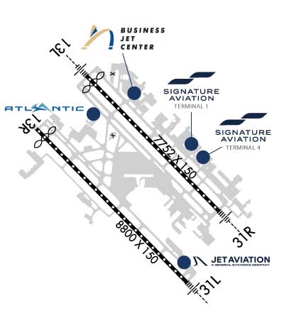
| FBOs at nearby airports who want your business: | |||||||||||||||||
| |||||||||||||||||
| |||||||||||||||||
| |||||||||||||||||
| Rwy | Rwy | |||||||
| 7752x150 | 7353' | 111.50 - 132° | 7752x150 | 7752' | 111.50 - 312° | |||
| 8800x150 | 8311' | 111.10 - 132° | 8800x150 | 8800' | 111.10 - 312° | |||
| Runway ID | Single Wheel | Double Wheel | Double Tandem Wheel | Dual Double Wheel |
| 13L/31R | 100,000 | 200,000 | 350,000 | N/A |
| 13R/31L | 120,000 | 250,000 | 388,000 | 875,000 |
| These numbers are Advisory and are not limits. The Airport Manager should have more accurate Weight Limits | ||||
 Airport Diagram might not be current. | |
| Facility Name: | DALLAS LOVE FLD |
| City Name: | DALLAS |
| County: | DALLAS |
| State abbrev: | TX |
| State Name: | TEXAS |
| Ownership: | PUBLICLY OWNED |
| Use: | OPEN TO THE PUBLIC |
| Owner's Name: | CITY OF DALLAS |
| Address: | CITY HALL |
| DALLAS, TX 75201 | |
| Owner's Phone: | 214-670-3011 |
| Manager's Name: | PATRICK CARRENO |
| Address: | DEPARTMENT OF AVIATION, 7555 LEMMON AVENUE |
| DALLAS, TX 75209 | |
| Phone: | 214-670-5683 |
| FAA Region: | SOUTHWEST |
| FAA Field Office: | TEX |
| Date | Sunrise | Sunset |
|---|---|---|
| 01/11/26 Sunday | 7:31 | 17:40 |
| 01/12/26 Monday | 7:31 | 17:41 |
| 01/13/26 Tuesday | 7:31 | 17:42 |
| 01/14/26 Wednesday | 7:30 | 17:43 |
| 01/15/26 Thursday | 7:30 | 17:44 |
| 01/16/26 Friday | 7:30 | 17:45 |
| 01/17/26 Saturday | 7:30 | 17:46 |
| 01/18/26 Sunday | 7:30 | 17:47 |
| 01/19/26 Monday | 7:29 | 17:48 |
| 01/20/26 Tuesday | 7:29 | 17:49 |
| 01/21/26 Wednesday | 7:28 | 17:49 |
| 01/22/26 Thursday | 7:28 | 17:50 |
| 01/23/26 Friday | 7:28 | 17:51 |
| 01/24/26 Saturday | 7:27 | 17:52 |
| Airport Attendance Schedule | CONTINUOUS |
| Airport Status | OPERATIONAL (This Status can change at any time - please check NOTAMS) |
| Airport Lighting Schedule | SS-SR |
| Airport Storage Available | Tie Downs, Hanger |
| Extra Services Available | Air Ambulance, Avionics, Charter, Flight Instruction, Aircraft Rental, Aircraft Sales |
| Wind Indicator | YES - (lighted) |
| Control Tower | YES |
| CTAF Frequency | |
| Unicom Frequency | |
| Rotating Beacon Color | WG |
| Segmented Circle | NO |
| Landing Fee | NO |
| Airport Inspected | FEDERAL - performed by FAA AIRPORTS FIELD PERSONNEL |
| Inspection Date | 08/14/2025 |
| Type of Fuel Available | Grade 100LL, JET A (freeze point -40C) |
| Airframe Repair Service | MAJOR |
| Power Plant Repair Service | MAJOR |
| Latitude | N3250.8 |
| Longitude | W09651.1 (ESTIMATED) |
| Arpt Elevation | 486ft (SURVEYED) |
| Magnetic Variation | 03E |
| 5 miles NW | of DALLAS |
| Traffic Pattern Altitude | |
| Sectional Chart | DALLAS-FT WORTH |
| Operations (Reported) | Yearly | Avg. Daily |
|---|---|---|
| General Aviation Transient | 0 | 0 |
| General Aviation Local | 0 | 0 |
| Air Taxi | 0 | 0 |
| Commerical | 0 | 0 |
| Commuter | 0 | 0 |
| Military | 0 | 0 |
| Aircraft based on Field | |
|---|---|
| General Aviation Singles | 0 |
| General Aviation Multi | 0 |
| Jet Aircraft | 0 |
| General Aviation Helicopters | 0 |
| Military Aircraft | 0 |
| Gliders | 0 |
| Ultralights | 0 |
| FSS on field | NO |
| FSS tie-in | FORT WORTH |
| FSS Phone | 1-800-WX-BRIEF |
| Who issues Notams | DAL |
| Notam D service at airport | YES |
| ARTCC Name | FORT WORTH |
| Airport Certification | AIRPORT RECEIVING SCHEDULED AIR CARRIER SERVICE FROM CARRIERS CERTIFICATED BY THE CIVIL AERONAUTICS BOARD |
| Aircraft Rescue & Firefighting Index | AIRPORT HAS A CERTIFICATE UNDER CFR PART 139 |
| Airport of Entry | No |
| Custom Landing Rights | No; US CUSTOMS USER FEE ARPT. |
| Joint Civil/Military | No |
| Military Landing rights | No |
| NATIONAL PLAN OF INTEGRATED AIRPORT SYSTEMS (NPIAS) |
| GRANT AGREEMENTS UNDER FAAP/ADAP/AIP |
| ASSURANCES PURSUANT TO TITLE VI, CIVIL RIGHTS ACT OF 1964 |
| TWY ALL CLSD TO ACFT WITH WINGSPAN 118 FT AND GTR EXC 1 HR PPR. 214-288-3069. |
| LDG FEE APRT |
| ACFT USING K RUNUP PAD BTN 0600-0000 MUST OBTAIN APVL FM ARPT OPNS CNTR 214-670-5683 PRIOR TO ENTERING. |
| K RUNUP PAD CLSD 0000-0600. |
| PILOTS CONDUCTING EFVS OPS; BE AWARE LED ALS IN USE RWY 31L & RWY 31R. |
| NOISE SENSITIVE AREAS ALL QUADRANTS; NOISE ABATEMENT PROCEDURES IN EFFECT JET AND AIRCRAFT OVER 12,500 LBS USE RWY 13R/31L BETWEEN 2100-0600 LCL. FOR INFORMATION CALL 214-670-5683. |
| BIRDS ON & INVOF ARPT. BIRD ACTIVITY TRINITY RIVER BOTTOM 3 MILES SW SIDE |
| PVT PILOT CERT OR BTR RQRD TO TKOF OR LAND. |
| NO STUDENT SOLO FLIGHTS PERMITTED. |
| TWY K CLSD THRU TRAFFIC. |
| PAEW ON ARPT. |
| RWY 13L/ 31RPCR VALUE: 450/R/B/W/T |
| RWY 13R/ 31LPCR VALUE: 865/R/D/W/T |
Airport Communications & Frequencies:
| |||||||||||||||||||||||||||||||||||||||||||||||||||||||||||
| Runway: 13L | Runway: 31R | ||
| Mag heading: | 133° | Mag heading: | 313° |
| Rwy Slope: | .13% Up | Rwy Slope: | -.13% Down |
| Approach: | ILS/DME | Approach: | ILS/DME |
| Pattern: | Left Traffic | Pattern: | Right Traffic |
| Markings: | PRECISION INSTRUMENT | Markings: | PRECISION INSTRUMENT |
| Marking Condition: | GOOD | Marking Condition: | GOOD |
| Arresting Dev: | Arresting Dev: | ||
| Lat & Long: | N3251.4 W09651.4 | Lat. & Long.: | N3250.5 W09650.3 |
| Elev: | 476.9 ft. MSL | Elev: | 486.9 ft. MSL |
| TCH: | 57 ft. AGL | TCH: | 55 ft. AGL |
| Visual Glide Path: | 3.00 degrees | Visual Glide Path: | 3.00 degrees |
| Displaced Threshold: | 399 feet | Displaced Threshold: | No |
| Touchdown Zone: | YES | Touchdown Zone: | YES |
| Touchdown Elev.: | 484.8 feet | Touchdown Elev.: | 486.9 feet |
| Visual Glide Slope: | 4-Light PAPI on RIGHT side of Runway | Visual Glide Slope: | 4-Light PAPI on LEFT side of Runway |
| RVR Equipment: | TOUCHDOWN-ROLLOUT | RVR Equipment: | TOUCHDOWN-ROLLOUT |
| RVV Equipment: | NO | RVV Equipment: | NO |
| Approach Lights: | MALSR - 1,400 foot medium intensity approach lighting system with runway alignment indicator lights | Approach Lights: | MALSR - 1,400 foot medium intensity approach lighting system with runway alignment indicator lights |
| REIL: | NO | REIL: | NO |
| Centerline Lights: | YES | Centerline Lights: | YES |
| Touchdown lights: | YES | Touchdown lights: | NO |
| Runway Category: | Precision Instrument Runway | Runway Category: | Precision Instrument Runway |
| Declared Distances: | TORA:7752' TODA:7752' ASDA:7752' LDA:7352' | Declared Distances: | TORA:7752' TODA:7752' ASDA:6952' LDA:6952' |
| Obstructions: | Obstructions: | POLE | |
| Marked: | Marked: | NOT Marked/Lighted | |
| Clearance slope: | 50:1 | Clearance slope: | 34:1 |
| Obstruction height: | Obstruction height: | 30 feet AGL | |
| Dist. from runway: | Dist. from runway: | 1227 feet | |
| Centerline offset: | Centerline offset: | 628 feet right of centerline | |
| Comments: | Comments: |
| Runway: 13R | Runway: 31L | ||
| Mag heading: | 133° | Mag heading: | 313° |
| Rwy Slope: | .00% | Rwy Slope: | .00% |
| Approach: | ILS/DME | Approach: | ILS/DME |
| Pattern: | Right Traffic | Pattern: | Left Traffic |
| Markings: | PRECISION INSTRUMENT | Markings: | PRECISION INSTRUMENT |
| Marking Condition: | GOOD | Marking Condition: | GOOD |
| Arresting Dev: | Arresting Dev: | ||
| Lat & Long: | N3251.1 W09651.8 | Lat. & Long.: | N3250.0 W09650.6 |
| Elev: | 476.4 ft. MSL | Elev: | 476.4 ft. MSL |
| TCH: | 52 ft. AGL | TCH: | 55 ft. AGL |
| Visual Glide Path: | 3.00 degrees | Visual Glide Path: | 3.08 degrees |
| Displaced Threshold: | 489 feet | Displaced Threshold: | No |
| Touchdown Zone: | YES | Touchdown Zone: | YES |
| Touchdown Elev.: | 478.5 feet | Touchdown Elev.: | 476.5 feet |
| Visual Glide Slope: | 4-Light PAPI on RIGHT side of Runway | Visual Glide Slope: | 4-Light PAPI on LEFT side of Runway |
| RVR Equipment: | TOUCHDOWN-MIDFIELD | RVR Equipment: | TOUCHDOWN-MIDFIELD |
| RVV Equipment: | NO | RVV Equipment: | NO |
| Approach Lights: | Approach Lights: | MALSR - 1,400 foot medium intensity approach lighting system with runway alignment indicator lights | |
| REIL: | NO | REIL: | NO |
| Centerline Lights: | YES | Centerline Lights: | YES |
| Touchdown lights: | NO | Touchdown lights: | YES |
| Runway Category: | Precision Instrument Runway | Runway Category: | Precision Instrument Runway |
| Declared Distances: | TORA:8800' TODA:8800' ASDA:8800' LDA:8310' | Declared Distances: | TORA:8800' TODA:8800' ASDA:8000' LDA:8000' |
| Obstructions: | Obstructions: | BLDG | |
| Marked: | Marked: | LIGHTED | |
| Clearance slope: | 50:1; APCH SLOPE 50:1 FM DSPLCD THR. | Clearance slope: | 30:1 |
| Obstruction height: | Obstruction height: | 692 feet AGL | |
| Dist. from runway: | Dist. from runway: | 21555 feet | |
| Centerline offset: | Centerline offset: | 2102 feet left of centerline | |
| Comments: | Comments: |
Thanks for using FltPlan.com
all rights reserved © 1999-2026 by Flight Plan LLC