
| EUREKA EUREKA NV |
| |
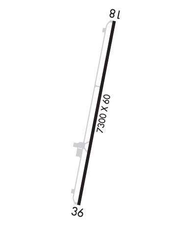
| Lat: N 3936.2 Long: W 11600.2 Elev: 5958 Var: -13 Longest Runway: 7300 | ||
| CTAF: 122.9 | ||
| ||||||||||||||||||||||||||||||||||||||||||||
| ||||||||||||||||||||||||||||||||||||||||||||
| ||||||||||||||||||||||||||||||||||||||||||||
| Rwy | Rwy | |||||||
| 7300x60 | 7300' | 7300x60 | 7300' | |||||
| Runway ID | Single Wheel | Double Wheel | Double Tandem Wheel | Dual Double Wheel |
| 18/36 | 30,000 | N/A | N/A | N/A |
| These numbers are Advisory and are not limits. The Airport Manager should have more accurate Weight Limits | ||||
 Airport Diagram might not be current. | |
| Facility Name: | EUREKA |
| City Name: | EUREKA |
| County: | EUREKA |
| State abbrev: | NV |
| State Name: | NEVADA |
| Ownership: | PUBLICLY OWNED |
| Use: | OPEN TO THE PUBLIC |
| Owner's Name: | COUNTY OF EUREKA |
| Address: | COUNTY COURT HOUSE BOX 677 |
| EUREKA, NV 89316 | |
| Owner's Phone: | 775-237-5372 |
| Manager's Name: | JEB ROWLEY |
| Address: | 701 S MAIN STREET, PO BOX 714 |
| EUREKA, NV 89316 | |
| Phone: | 775-237-5372 |
| FAA Region: | WESTERN-PACIFIC |
| FAA Field Office: | PHX |
| Date | Sunrise | Sunset |
|---|---|---|
| 09/24/21 Friday | 6:33 | 18:38 |
| 09/25/21 Saturday | 6:34 | 18:36 |
| 09/26/21 Sunday | 6:35 | 18:35 |
| 09/27/21 Monday | 6:36 | 18:33 |
| 09/28/21 Tuesday | 6:37 | 18:32 |
| 09/29/21 Wednesday | 6:38 | 18:30 |
| 09/30/21 Thursday | 6:39 | 18:28 |
| 10/01/21 Friday | 6:40 | 18:27 |
| 10/02/21 Saturday | 6:41 | 18:25 |
| 10/03/21 Sunday | 6:42 | 18:23 |
| 10/04/21 Monday | 6:43 | 18:22 |
| 10/05/21 Tuesday | 6:44 | 18:20 |
| 10/06/21 Wednesday | 6:45 | 18:19 |
| 10/07/21 Thursday | 6:46 | 18:17 |
| Airport Attendance Schedule | 7 Days A Week 0800-1700; AFTER HOURS CALL-OUT 775-237-6100. |
| Airport Status | OPERATIONAL (This Status can change at any time - please check NOTAMS) |
| Airport Lighting Schedule | DUSK-DAWN. REIL RWY 18 & 36; PAPI RWY 18 & 36; HIRL RWY 18/36 PRESET LOW INTST DUSK-DAWN, TO INCR INTST ACTVT - CTAF. |
| Airport Storage Available | Tie Downs, Hanger |
| Extra Services Available | Crop Dusting, Air Ambulance |
| Wind Indicator | YES - (lighted) |
| Control Tower | NO |
| CTAF Frequency | 122.900 |
| Unicom Frequency | |
| Rotating Beacon Color | CLEAR-GREEN (Light Land Airport) |
| Segmented Circle | YES |
| Landing Fee | NO |
| Airport Inspected | STATE - performed by STATE AERONAUTICAL PERSONNEL |
| Inspection Date | 08/09/2018 |
| Type of Fuel Available | Grade 100LL, JET A (freeze point -40C), JET A |
| Airframe Repair Service | MAJOR |
| Power Plant Repair Service | MAJOR |
| Latitude | N3936.2 |
| Longitude | W11600.2 (ESTIMATED) |
| Arpt Elevation | 5957ft (SURVEYED) |
| Magnetic Variation | 13E |
| 6 miles NW | of EUREKA |
| Traffic Pattern Altitude | |
| Sectional Chart | LAS VEGAS |
| Operations (Reported) | Yearly | Avg. Daily |
|---|---|---|
| General Aviation Transient | 980 | 3 |
| General Aviation Local | 450 | 1 |
| Air Taxi | 0 | 0 |
| Commerical | 0 | 0 |
| Commuter | 0 | 0 |
| Military | 160 | 0 |
| Aircraft based on Field | |
|---|---|
| General Aviation Singles | 1 |
| General Aviation Multi | 0 |
| Jet Aircraft | 0 |
| General Aviation Helicopters | 0 |
| Military Aircraft | 0 |
| Gliders | 0 |
| Ultralights | 0 |
| FSS on field | NO |
| FSS tie-in | RENO |
| FSS Phone | 1-800-WX-BRIEF |
| Who issues Notams | RNO |
| Notam D service at airport | YES |
| ARTCC Name | SALT LAKE CITY |
| Airport Certification | |
| Aircraft Rescue & Firefighting Index | None |
| Airport of Entry | No |
| Custom Landing Rights | No |
| Joint Civil/Military | No |
| Military Landing rights | YES |
| NATIONAL PLAN OF INTEGRATED AIRPORT SYSTEMS (NPIAS) |
| GRANT AGREEMENTS UNDER FAAP/ADAP/AIP |
| CONVEYANCE UNDER SCETION 16, FEDERAL AIRPORT ACT OF 1946 OR SECTION 23, AIRPORT AND AIRWAY DEVELOPMENT ACT OF 1970 |
| ASSURANCES PURSUANT TO TITLE VI, CIVIL RIGHTS ACT OF 1964 |
| FOR CD IF UNA TO CTC ON FSS FREQ, CTC SALT LAKE ARTCC AT 801-320-2568. |
| COLD TEMPERATURE AIRPORT. ALTITUDE CORRECTION REQUIRED AT OR BELOW -17C. |
| (PAY PHONE) PAY PHONE AVAILABLE. |
Airport Communications & Frequencies:
| |||||||
| Runway: 18 | Runway: 36 | ||
| Mag heading: | 178° | Mag heading: | 358° |
| Rwy Slope: | .25% Up | Rwy Slope: | -.25% Down |
| Approach: | Approach: | ||
| Pattern: | Left Traffic | Pattern: | Left Traffic |
| Markings: | NONPRECISION INSTRUMENT | Markings: | NONPRECISION INSTRUMENT |
| Marking Condition: | GOOD | Marking Condition: | GOOD |
| Arresting Dev: | Arresting Dev: | ||
| Lat & Long: | N3936.8 W11600.1 | Lat. & Long.: | N3935.6 W11600.4 |
| Elev: | 5939.5 ft. MSL | Elev: | 5957.8 ft. MSL |
| TCH: | 45 ft. AGL | TCH: | 40 ft. AGL |
| Visual Glide Path: | 3.00 degrees | Visual Glide Path: | 3.00 degrees |
| Displaced Threshold: | No | Displaced Threshold: | No |
| Touchdown Zone: | YES | Touchdown Zone: | YES |
| Touchdown Elev.: | 5944.3 feet | Touchdown Elev.: | 5957.8 feet |
| Visual Glide Slope: | 2-Light PAPI on LEFT side of Runway | Visual Glide Slope: | 2-Light PAPI on LEFT side of Runway |
| RVR Equipment: | RVR Equipment: | ||
| RVV Equipment: | NO | RVV Equipment: | NO |
| Approach Lights: | Approach Lights: | ||
| REIL: | YES | REIL: | YES |
| Centerline Lights: | NO | Centerline Lights: | NO |
| Touchdown lights: | NO | Touchdown lights: | NO |
| Runway Category: | Runway with a Non-precision Approach | Runway Category: | Runway with a Visual Approach |
| Declared Distances: | Declared Distances: | ||
| Obstructions: | Obstructions: | PLINE | |
| Marked: | Marked: | NOT Marked/Lighted | |
| Clearance slope: | 50:1; UNLIGHTED POWER LINES AND POLES PENETRATE APPROACH | Clearance slope: | 17:1 |
| Obstruction height: | Obstruction height: | 35 feet AGL | |
| Dist. from runway: | Dist. from runway: | 800 feet | |
| Centerline offset: | Centerline offset: | ||
| Comments: | Comments: |
Thanks for using FltPlan.com
all rights reserved © 1999-2021 by Flight Plan LLC
