
| QUINCY RGNL-BALDWIN FIELD QUINCY IL |
| |
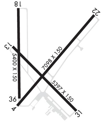
| Lat: N 3956.6 Long: W 09111.7 Elev: 769 Var: -02 Longest Runway: 7098 | ||
| AWOS: 121.42 CTAF: 123.0 | ||
| ||||||
| ||||||
|
| Rwy | Rwy | |||||||
| 7098x150 | 7098' | 110.10 - 038° | 7098x150 | 7098' | ||||
| 5397x150 | 5397' | 5397x150 | 5397' | |||||
| 5400x150 | 5400' | 5400x150 | 5400' | |||||
| Runway ID | Single Wheel | Double Wheel | Double Tandem Wheel | Dual Double Wheel |
| 04/22 | 120,000 | 231,000 | 373,000 | N/A |
| 13/31 | 120,000 | 231,000 | 373,000 | N/A |
| 18/36 | 106,000 | 142,000 | N/A | N/A |
| These numbers are Advisory and are not limits. The Airport Manager should have more accurate Weight Limits | ||||
 Airport Diagram might not be current. | |
| Facility Name: | QUINCY RGNL-BALDWIN FLD |
| City Name: | QUINCY |
| County: | ADAMS |
| State abbrev: | IL |
| State Name: | ILLINOIS |
| Ownership: | PUBLICLY OWNED |
| Use: | OPEN TO THE PUBLIC |
| Owner's Name: | CITY OF QUINCY |
| Address: | 1645 HWY 104 |
| QUINCY, IL 62305 | |
| Owner's Phone: | 217-885-3285; EXT: 8. |
| Manager's Name: | SANDRA SHORE; EMAIL ADDRESS: QUINCYAIRPORT@QUINCYIL.GOV |
| Address: | 1645 HWY 104 |
| QUINCY, IL 62305 | |
| Phone: | 217-885-3262 |
| FAA Region: | GREAT LAKES |
| FAA Field Office: | CHI |
| Date | Sunrise | Sunset |
|---|---|---|
| 09/24/21 Friday | 6:54 | 18:59 |
| 09/25/21 Saturday | 6:55 | 18:57 |
| 09/26/21 Sunday | 6:56 | 18:56 |
| 09/27/21 Monday | 6:57 | 18:54 |
| 09/28/21 Tuesday | 6:58 | 18:52 |
| 09/29/21 Wednesday | 6:59 | 18:51 |
| 09/30/21 Thursday | 7:00 | 18:49 |
| 10/01/21 Friday | 7:01 | 18:47 |
| 10/02/21 Saturday | 7:02 | 18:46 |
| 10/03/21 Sunday | 7:03 | 18:44 |
| 10/04/21 Monday | 7:04 | 18:43 |
| 10/05/21 Tuesday | 7:05 | 18:41 |
| 10/06/21 Wednesday | 7:06 | 18:39 |
| 10/07/21 Thursday | 7:07 | 18:38 |
| Airport Attendance Schedule | MON-FRI 0530-2200, SAT 0530-2200, SUN 0530-2200; FOR FUEL ATTENDANT OTR HRS CALL 217-885-3353 OR 217-779-5091. ACFT MAINT HRS MON-FRI 0700-1530, AFT HRS 217-257-1139. |
| Airport Status | OPERATIONAL (This Status can change at any time - please check NOTAMS) |
| Airport Lighting Schedule | ACTVT MALSR RWY 04; REIL RWY 18 & 22; PAPI RWY 13, 31, 04 & 22; HIRL RWY 04/22; MIRL RWY 13/31; MIRL RWY 18/36 - CTAF. HIRL RWY 04/22 PRESET LOW INTST; TO INCR INTST - CTAF. |
| Airport Storage Available | Tie Downs |
| Extra Services Available | Air Ambulance, Charter, Flight Instruction, Aircraft Rental |
| Wind Indicator | YES - (lighted) |
| Control Tower | NO |
| CTAF Frequency | 123.000 |
| Unicom Frequency | 123.000 |
| Rotating Beacon Color | CLEAR-GREEN (Light Land Airport) |
| Segmented Circle | YES |
| Landing Fee | NO |
| Airport Inspected | FEDERAL - performed by FAA AIRPORTS FIELD PERSONNEL |
| Inspection Date | 11/15/2019 |
| Type of Fuel Available | Grade 100LL, JET A (freeze point -40C) |
| Airframe Repair Service | MAJOR |
| Power Plant Repair Service | MAJOR |
| Latitude | N3956.6 |
| Longitude | W09111.7 (ESTIMATED) |
| Arpt Elevation | 768ft (SURVEYED) |
| Magnetic Variation | 02E |
| 10 miles E | of QUINCY |
| Traffic Pattern Altitude | |
| Sectional Chart | KANSAS CITY |
| Operations (Reported) | Yearly | Avg. Daily |
|---|---|---|
| General Aviation Transient | 2050 | 6 |
| General Aviation Local | 13560 | 37 |
| Air Taxi | 3808 | 10 |
| Commerical | 0 | 0 |
| Commuter | 0 | 0 |
| Military | 26 | 0 |
| Aircraft based on Field | |
|---|---|
| General Aviation Singles | 33 |
| General Aviation Multi | 7 |
| Jet Aircraft | 13 |
| General Aviation Helicopters | 0 |
| Military Aircraft | 0 |
| Gliders | 0 |
| Ultralights | 1 |
| FSS on field | NO |
| FSS tie-in | SAINT LOUIS |
| FSS Phone | 1-800-WX-BRIEF |
| Who issues Notams | UIN |
| Notam D service at airport | YES |
| ARTCC Name | KANSAS CITY |
| Airport Certification | |
| Aircraft Rescue & Firefighting Index | AIRPORT HAS A CERTIFICATE UNDER CFR PART 139 |
| Airport of Entry | No |
| Custom Landing Rights | No |
| Joint Civil/Military | No |
| Military Landing rights | YES |
| NATIONAL PLAN OF INTEGRATED AIRPORT SYSTEMS (NPIAS) |
| GRANT AGREEMENTS UNDER FAAP/ADAP/AIP |
| ASSURANCES PURSUANT TO TITLE VI, CIVIL RIGHTS ACT OF 1964 |
| AGREEMENT UNDER DLAND OR DCLA HAS EXPIRED. |
| MIGRATORY WATERFOWL ON & INVOF ARPT. |
| FICON ARE NOT MONTRD BTWN THE HRS OF 2100-0600. |
| ARPT WDI OTS INDEFLY. |
| USE CTN; NO LINE OF SIGHT BTWN RWY ENDS DUE TO TOPOGRAPHY AND BLDG OBSTNS; ALL DEP/ARR ACFT USE CTAF 123.0. |
| FOR CD IF UNA TO CTC ON FSS FREQ, CTC KANSAS CITY ARTCC AT 913-254-8508. |
| ARFF NOT AVBL 24 HRS. 24HRS PPR FOR UNSKED ACR OPNS WITH MORE THAN 9 PAX SEATS; CTC ARPT MGR 217-885-3285 OR 217-885-3262. |
| RWY 04 IS THE PREFERRED RWY IN CALM WIND CONDITIONS. |
| RWY 18/3 6 RWY 18/36 NOT AVBL FOR SKEDD ACR OPNS WITH MORE THAN 9 PSGR SEATS OR UNSCHEDULED ACR AT LEAST 31 PSGR SEATS. |
| RWY 04/2 2 NE 1300 FT CONC. |
| RWY 18/3 6 N 479 FT CONC. |
Airport Communications & Frequencies:
| |||||||||
| Runway: 04 | Runway: 22 | ||
| Mag heading: | 38° | Mag heading: | 218° |
| Rwy Slope: | -.13% Down | Rwy Slope: | .13% Up |
| Approach: | ILS | Approach: | |
| Pattern: | Left Traffic | Pattern: | Left Traffic |
| Markings: | PRECISION INSTRUMENT | Markings: | PRECISION INSTRUMENT |
| Marking Condition: | GOOD | Marking Condition: | GOOD |
| Arresting Dev: | Arresting Dev: | ||
| Lat & Long: | N3956.2 W09112.0 | Lat. & Long.: | N3957.1 W09111.0 |
| Elev: | 755.7 ft. MSL | Elev: | 746.4 ft. MSL |
| TCH: | 42 ft. AGL | TCH: | 46 ft. AGL |
| Visual Glide Path: | 3.00 degrees | Visual Glide Path: | 3.00 degrees |
| Displaced Threshold: | No | Displaced Threshold: | No |
| Touchdown Zone: | YES | Touchdown Zone: | YES |
| Touchdown Elev.: | 759.5 feet | Touchdown Elev.: | 746.8 feet |
| Visual Glide Slope: | 4-Light PAPI on RIGHT side of Runway | Visual Glide Slope: | 4-Light PAPI on LEFT side of Runway |
| RVR Equipment: | RVR Equipment: | ||
| RVV Equipment: | YES | RVV Equipment: | NO |
| Approach Lights: | MALSR - 1,400 foot medium intensity approach lighting system with runway alignment indicator lights | Approach Lights: | |
| REIL: | NO | REIL: | YES |
| Centerline Lights: | NO | Centerline Lights: | NO |
| Touchdown lights: | NO | Touchdown lights: | NO |
| Runway Category: | Precision Instrument Runway | Runway Category: | Runway with a Non-precision Approach having visibility minimums greater than 3/4 mile |
| Declared Distances: | TORA:7098' TODA:7098' ASDA:7098' LDA:7098' | Declared Distances: | TORA:7098' TODA:7098' ASDA:7098' LDA:7098' |
| Obstructions: | ROAD | Obstructions: | |
| Marked: | NOT Marked/Lighted | Marked: | |
| Clearance slope: | 40:1 | Clearance slope: | 50:1 |
| Obstruction height: | 16 feet AGL | Obstruction height: | |
| Dist. from runway: | 848 feet | Dist. from runway: | |
| Centerline offset: | 586 right of centerline | Centerline offset: | |
| Comments: | Comments: |
| Runway: 13 | Runway: 31 | ||
| Mag heading: | 133° | Mag heading: | 313° |
| Rwy Slope: | .06% Up | Rwy Slope: | -.06% Down |
| Approach: | Approach: | ||
| Pattern: | Left Traffic | Pattern: | Left Traffic |
| Markings: | NONPRECISION INSTRUMENT | Markings: | NONPRECISION INSTRUMENT |
| Marking Condition: | GOOD | Marking Condition: | GOOD |
| Arresting Dev: | Arresting Dev: | ||
| Lat & Long: | N3956.8 W09112.0 | Lat. & Long.: | N3956.1 W09111.2 |
| Elev: | 765.3 ft. MSL | Elev: | 768.7 ft. MSL |
| TCH: | 33 ft. AGL | TCH: | 40 ft. AGL |
| Visual Glide Path: | 3.00 degrees | Visual Glide Path: | 3.00 degrees |
| Displaced Threshold: | No | Displaced Threshold: | No |
| Touchdown Zone: | YES | Touchdown Zone: | YES |
| Touchdown Elev.: | 766.8 feet | Touchdown Elev.: | 768.7 feet |
| Visual Glide Slope: | 4-Light PAPI on LEFT side of Runway; PAPI UNUSBL BYD 9 DEGS RIGHT OF CNTRLN. | Visual Glide Slope: | 4-Light PAPI on RIGHT side of Runway |
| RVR Equipment: | RVR Equipment: | ||
| RVV Equipment: | NO | RVV Equipment: | NO |
| Approach Lights: | Approach Lights: | ||
| REIL: | NO | REIL: | NO |
| Centerline Lights: | NO | Centerline Lights: | NO |
| Touchdown lights: | NO | Touchdown lights: | NO |
| Runway Category: | Runway with a Non-precision Approach having visibility minimums greater than 3/4 mile | Runway Category: | Runway with a Non-precision Approach having visibility minimums greater than 3/4 mile |
| Declared Distances: | TORA:5397' TODA:5397' ASDA:5123' LDA:5123' | Declared Distances: | TORA:5397' TODA:5397' ASDA:5146' LDA:5146' |
| Obstructions: | ROAD | Obstructions: | POLE |
| Marked: | NOT Marked/Lighted | Marked: | NOT Marked/Lighted |
| Clearance slope: | 29:1 | Clearance slope: | 40:1 |
| Obstruction height: | 11 feet AGL | Obstruction height: | 15 feet AGL |
| Dist. from runway: | 525 feet | Dist. from runway: | 800 feet |
| Centerline offset: | 300 right of centerline | Centerline offset: | 200 feet left of centerline |
| Comments: | Comments: |
| Runway: 18 | Runway: 36 | ||
| Mag heading: | 177° | Mag heading: | 357° |
| Rwy Slope: | .00% Down | Rwy Slope: | .00% Up |
| Approach: | Approach: | ||
| Pattern: | Left Traffic | Pattern: | Left Traffic |
| Markings: | NONPRECISION INSTRUMENT | Markings: | NONPRECISION INSTRUMENT |
| Marking Condition: | GOOD | Marking Condition: | GOOD |
| Arresting Dev: | Arresting Dev: | ||
| Lat & Long: | N3957.1 W09112.0 | Lat. & Long.: | N3956.2 W09111.9 |
| Elev: | 757.0 ft. MSL | Elev: | 756.9 ft. MSL |
| TCH: | TCH: | ||
| Visual Glide Path: | Visual Glide Path: | ||
| Displaced Threshold: | No | Displaced Threshold: | No |
| Touchdown Zone: | YES | Touchdown Zone: | YES |
| Touchdown Elev.: | 759.8 feet | Touchdown Elev.: | 759.4 feet |
| Visual Glide Slope: | Visual Glide Slope: | ||
| RVR Equipment: | RVR Equipment: | ||
| RVV Equipment: | NO | RVV Equipment: | NO |
| Approach Lights: | Approach Lights: | ||
| REIL: | YES | REIL: | NO |
| Centerline Lights: | NO | Centerline Lights: | NO |
| Touchdown lights: | NO | Touchdown lights: | NO |
| Runway Category: | Runway with a Non-precision Approach having visibility minimums greater than 3/4 mile | Runway Category: | Runway with a Non-precision Approach having visibility minimums greater than 3/4 mile |
| Declared Distances: | TORA:5400' TODA:5400' ASDA:5400' LDA:5400' | Declared Distances: | TORA:5400' TODA:5400' ASDA:5400' LDA:5400' |
| Obstructions: | TREES | Obstructions: | ROAD |
| Marked: | NOT Marked/Lighted | Marked: | NOT Marked/Lighted |
| Clearance slope: | 26:1 | Clearance slope: | 48:1 |
| Obstruction height: | 39 feet AGL | Obstruction height: | 16 feet AGL |
| Dist. from runway: | 1245 feet | Dist. from runway: | 976 feet |
| Centerline offset: | 75 right of centerline | Centerline offset: | 245 feet left of centerline |
| Comments: | Comments: |
Thanks for using FltPlan.com
all rights reserved © 1999-2021 by Flight Plan LLC
