
| MENOMONIE MUNI-SCORE FIELD MENOMONIE WI |
| |
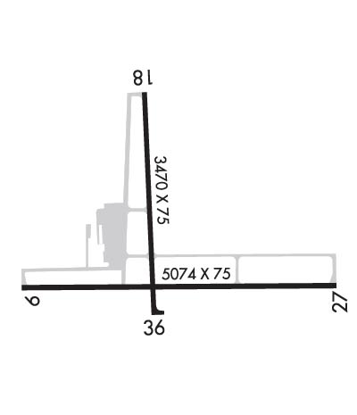
| Lat: N 4453.5 Long: W 09152.1 Elev: 895 Var: -01 Longest Runway: 5074 | ||
| AWOS: 118.02 CTAF: 122.7 | ||
| ||||||||||||||||||||||||||||||||||||||||||||||||||||||||||||||||||||
| ||||||||||||||||||||||||||||||||||||||||||||||||||||||||||||||||||||
| ||||||||||||||||||||||||||||||||||||||||||||||||||||||||||||||||||||
| Rwy | Rwy | |||||||
| 5074x75 | 5074' | 5074x75 | 5074' | |||||
| 3470x75 | 3470' | 3470x75 | 3470' | |||||
| Runway ID | Single Wheel | Double Wheel | Double Tandem Wheel | Dual Double Wheel |
| 09/27 | N/A | N/A | N/A | N/A |
| 18/36 | N/A | N/A | N/A | N/A |
| These numbers are Advisory and are not limits. The Airport Manager should have more accurate Weight Limits | ||||
 Airport Diagram might not be current. | |
| Facility Name: | MENOMONIE MUNI-SCORE FLD |
| City Name: | MENOMONIE |
| County: | DUNN |
| State abbrev: | WI |
| State Name: | WISCONSIN |
| Ownership: | PUBLICLY OWNED |
| Use: | OPEN TO THE PUBLIC |
| Owner's Name: | CITY OF MENOMONIE |
| Address: | 800 WILSON AVE |
| MENOMONIE, WI 54751-2795 | |
| Owner's Phone: | 715-232-2187 |
| Manager's Name: | DARREL GIBSON |
| Address: | 1400 INDIANHEAD DR. |
| MENOMONIE, WI 54751 | |
| Phone: | (715) 220-6549 |
| FAA Region: | GREAT LAKES |
| FAA Field Office: | CHI |
| Date | Sunrise | Sunset |
|---|---|---|
| 09/24/21 Friday | 6:57 | 19:02 |
| 09/25/21 Saturday | 6:58 | 19:00 |
| 09/26/21 Sunday | 6:59 | 18:58 |
| 09/27/21 Monday | 7:00 | 18:56 |
| 09/28/21 Tuesday | 7:01 | 18:54 |
| 09/29/21 Wednesday | 7:03 | 18:52 |
| 09/30/21 Thursday | 7:04 | 18:50 |
| 10/01/21 Friday | 7:05 | 18:48 |
| 10/02/21 Saturday | 7:06 | 18:47 |
| 10/03/21 Sunday | 7:08 | 18:45 |
| 10/04/21 Monday | 7:09 | 18:43 |
| 10/05/21 Tuesday | 7:10 | 18:41 |
| 10/06/21 Wednesday | 7:11 | 18:39 |
| 10/07/21 Thursday | 7:13 | 18:37 |
| Airport Attendance Schedule | MON-FRI 0800-1700 |
| Airport Status | OPERATIONAL (This Status can change at any time - please check NOTAMS) |
| Airport Lighting Schedule | ACTVT REIL RWY 09 & 27; MIRL RWY 09/27 & 18/36 - CTAF. MIRL RWY 9/27 PRESET TO LOW INTST; INCR INTST - CTAF. PAPI RWY 9, 18, 27 & 36 OPR CONSLY. |
| Airport Storage Available | Tie Downs, Hanger |
| Extra Services Available | Flight Instruction, Aircraft Rental |
| Wind Indicator | YES - (lighted) |
| Control Tower | NO |
| CTAF Frequency | 122.700 |
| Unicom Frequency | 122.700 |
| Rotating Beacon Color | CLEAR-GREEN (Light Land Airport) |
| Segmented Circle | NO |
| Landing Fee |
| Airport Inspected | STATE - performed by STATE AERONAUTICAL PERSONNEL |
| Inspection Date | 07/22/2020 |
| Type of Fuel Available | Grade 100LL, JET A (freeze point -40C); -1024 HR SELF SVC FUEL AVBL WITH CREDIT CARD; CTC AMGR FOR ASSTNC. |
| Airframe Repair Service | MAJOR |
| Power Plant Repair Service | MAJOR |
| Latitude | N4453.5 |
| Longitude | W09152.1 (ESTIMATED) |
| Arpt Elevation | 895ft (SURVEYED) |
| Magnetic Variation | 01E |
| 3 miles E | of MENOMONIE |
| Traffic Pattern Altitude | |
| Sectional Chart | GREEN BAY |
| Operations (Reported) | Yearly | Avg. Daily |
|---|---|---|
| General Aviation Transient | 2500 | 7 |
| General Aviation Local | 11000 | 30 |
| Air Taxi | 50 | 0 |
| Commerical | 0 | 0 |
| Commuter | 0 | 0 |
| Military | 0 | 0 |
| Aircraft based on Field | |
|---|---|
| General Aviation Singles | 27 |
| General Aviation Multi | 2 |
| Jet Aircraft | 0 |
| General Aviation Helicopters | 0 |
| Military Aircraft | 0 |
| Gliders | 1 |
| Ultralights | 0 |
| FSS on field | NO |
| FSS tie-in | GREEN BAY |
| FSS Phone | 1-800-WX-BRIEF |
| Who issues Notams | LUM |
| Notam D service at airport | YES |
| ARTCC Name | MINNEAPOLIS |
| Airport Certification | |
| Aircraft Rescue & Firefighting Index | None |
| Airport of Entry | No |
| Custom Landing Rights | No |
| Joint Civil/Military | No |
| Military Landing rights | No |
| NATIONAL PLAN OF INTEGRATED AIRPORT SYSTEMS (NPIAS) |
| THIS AIRPORT HAS BEEN SURVEYED BY THE NATIONAL GEODETIC SURVEY. |
| SEASONAL BIRDS ON & INVOF ARPT. |
| FOR CD CTC MINNEAPOLIS ARTCC AT 651-463-5588. |
| NOISE SENSITIVE NBRHD W OF RWY 27. |
Airport Communications & Frequencies:
| |||||||||
| Runway: 09 | Runway: 27 | ||
| Mag heading: | 88° | Mag heading: | 268° |
| Rwy Slope: | .01% Up | Rwy Slope: | -.01% Down |
| Approach: | Approach: | ||
| Pattern: | Left Traffic | Pattern: | Left Traffic |
| Markings: | NONPRECISION INSTRUMENT | Markings: | NONPRECISION INSTRUMENT |
| Marking Condition: | GOOD | Marking Condition: | GOOD |
| Arresting Dev: | Arresting Dev: | ||
| Lat & Long: | N4453.4 W09152.6 | Lat. & Long.: | N4453.5 W09151.4 |
| Elev: | 892.2 ft. MSL | Elev: | 892.8 ft. MSL |
| TCH: | 48 ft. AGL | TCH: | 45 ft. AGL |
| Visual Glide Path: | 3.00 degrees | Visual Glide Path: | 3.00 degrees |
| Displaced Threshold: | No | Displaced Threshold: | No |
| Touchdown Zone: | YES | Touchdown Zone: | YES |
| Touchdown Elev.: | 893.6 feet | Touchdown Elev.: | 893.6 feet |
| Visual Glide Slope: | 2-Light PAPI on LEFT side of Runway | Visual Glide Slope: | 2-Light PAPI on LEFT side of Runway |
| RVR Equipment: | RVR Equipment: | ||
| RVV Equipment: | NO | RVV Equipment: | NO |
| Approach Lights: | Approach Lights: | ||
| REIL: | YES | REIL: | YES |
| Centerline Lights: | NO | Centerline Lights: | NO |
| Touchdown lights: | NO | Touchdown lights: | NO |
| Runway Category: | D | Runway Category: | D |
| Declared Distances: | Declared Distances: |
| Runway: 18 | Runway: 36 | ||
| Mag heading: | 176° | Mag heading: | 356° |
| Rwy Slope: | -.06% Down | Rwy Slope: | .06% Up |
| Approach: | Approach: | ||
| Pattern: | Left Traffic | Pattern: | Left Traffic |
| Markings: | NONPRECISION INSTRUMENT | Markings: | NONPRECISION INSTRUMENT |
| Marking Condition: | GOOD | Marking Condition: | GOOD |
| Arresting Dev: | Arresting Dev: | ||
| Lat & Long: | N4454.0 W09152.1 | Lat. & Long.: | N4453.4 W09152.1 |
| Elev: | 895.1 ft. MSL | Elev: | 893.0 ft. MSL |
| TCH: | 43 ft. AGL | TCH: | 39 ft. AGL |
| Visual Glide Path: | 3.00 degrees | Visual Glide Path: | 3.00 degrees |
| Displaced Threshold: | No | Displaced Threshold: | No |
| Touchdown Zone: | YES | Touchdown Zone: | YES |
| Touchdown Elev.: | 895.1 feet | Touchdown Elev.: | 893.6 feet |
| Visual Glide Slope: | 2-Light PAPI on LEFT side of Runway | Visual Glide Slope: | 2-Light PAPI on RIGHT side of Runway |
| RVR Equipment: | RVR Equipment: | ||
| RVV Equipment: | NO | RVV Equipment: | NO |
| Approach Lights: | Approach Lights: | ||
| REIL: | NO | REIL: | NO |
| Centerline Lights: | NO | Centerline Lights: | NO |
| Touchdown lights: | NO | Touchdown lights: | NO |
| Runway Category: | Runway with a Visual Approach | Runway Category: | Runway with a Visual Approach |
| Declared Distances: | Declared Distances: |
Thanks for using FltPlan.com
all rights reserved © 1999-2021 by Flight Plan LLC


