
| HARRY CLEVER FIELD NEW PHILADELPHIA OH |
| |
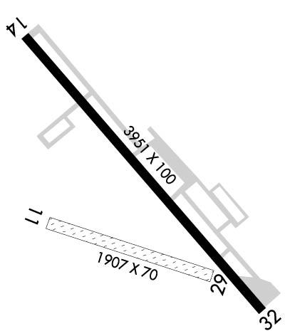
| Lat: N 4028.2 Long: W 08125.2 Elev: 894 Var: +08 Longest Runway: 3951 | ||
| AWOS: 121.42 CTAF: 122.8 | ||
| ||||||||||||||||||||||||||||||||||||||||||||||||||||||||||||||||||||
| ||||||||||||||||||||||||||||||||||||||||||||||||||||||||||||||||||||
| ||||||||||||||||||||||||||||||||||||||||||||||||||||||||||||||||||||
| Rwy | Rwy | |||||||
| 1907x70 | 1907' | 1907x70 | 1907' | |||||
| 3951x100 | 3621' | 3951x100 | 3951' | |||||
| Runway ID | Single Wheel | Double Wheel | Double Tandem Wheel | Dual Double Wheel |
| 12/30 | N/A | N/A | N/A | N/A |
| 15/33 | 52,500 | 67,500 | 140,000 | N/A |
| These numbers are Advisory and are not limits. The Airport Manager should have more accurate Weight Limits | ||||
 Airport Diagram might not be current. | |
| Facility Name: | HARRY CLEVER FLD |
| City Name: | NEW PHILADELPHIA |
| County: | TUSCARAWAS |
| State abbrev: | OH |
| State Name: | OHIO |
| Ownership: | PUBLICLY OWNED |
| Use: | OPEN TO THE PUBLIC |
| Owner's Name: | CITY OF NEW PHILADELPHIA |
| Address: | SERVICE DIRECTOR, 150 E HIGH AVE STE 200 |
| NEW PHILADELPHIA, OH 44663-4500 | |
| Owner's Phone: | 330-364-4491 |
| Manager's Name: | ERIC HUBBARD |
| Address: | 1834 E HIGH AVE |
| NEW PHILADELPHIA, OH 44663-3239 | |
| Phone: | 330-339-6078; CELL 330-827-0820. |
| FAA Region: | GREAT LAKES |
| FAA Field Office: | DET |
| Date | Sunrise | Sunset |
|---|---|---|
| 04/24/24 Wednesday | 6:33 | 20:15 |
| 04/25/24 Thursday | 6:32 | 20:16 |
| 04/26/24 Friday | 6:30 | 20:17 |
| 04/27/24 Saturday | 6:29 | 20:18 |
| 04/28/24 Sunday | 6:28 | 20:19 |
| 04/29/24 Monday | 6:26 | 20:20 |
| 04/30/24 Tuesday | 6:25 | 20:21 |
| 05/01/24 Wednesday | 6:24 | 20:22 |
| 05/02/24 Thursday | 6:23 | 20:23 |
| 05/03/24 Friday | 6:21 | 20:24 |
| 05/04/24 Saturday | 6:20 | 20:25 |
| 05/05/24 Sunday | 6:19 | 20:26 |
| 05/06/24 Monday | 6:18 | 20:27 |
| 05/07/24 Tuesday | 6:17 | 20:28 |
| Airport Attendance Schedule | MON-FRI 0730-1700; CLSD MAJOR HOLS; FOR SVC AFT HRS CALL AMGR CELL. |
| Airport Status | OPERATIONAL (This Status can change at any time - please check NOTAMS) |
| Airport Lighting Schedule | ACTVT REIL RWY 15 & 33; MIRL RWY 15/33 - 123.3. PAPI RWY 15 & 33 OPR CONSLY. |
| Airport Storage Available | Tie Downs, Hanger |
| Extra Services Available | Avionics, Flight Instruction, Aircraft Rental |
| Wind Indicator | YES - (lighted) |
| Control Tower | NO |
| CTAF Frequency | 122.800 |
| Unicom Frequency | 122.800 |
| Rotating Beacon Color | WG |
| Segmented Circle | NO |
| Landing Fee | NO |
| Airport Inspected | STATE - performed by STATE AERONAUTICAL PERSONNEL |
| Inspection Date | 09/26/2023 |
| Type of Fuel Available | Grade 100LL, JET A (freeze point -40C) |
| Airframe Repair Service | MAJOR |
| Power Plant Repair Service | MAJOR |
| Latitude | N4028.2 |
| Longitude | W08125.2 (ESTIMATED) |
| Arpt Elevation | 894ft (SURVEYED) |
| Magnetic Variation | 08W |
| 2 miles SE | of NEW PHILADELPHIA |
| Traffic Pattern Altitude | |
| Sectional Chart | DETROIT |
| Operations (Reported) | Yearly | Avg. Daily |
|---|---|---|
| General Aviation Transient | 5425 | 15 |
| General Aviation Local | 15000 | 41 |
| Air Taxi | 785 | 2 |
| Commerical | 0 | 0 |
| Commuter | 0 | 0 |
| Military | 140 | 0 |
| Aircraft based on Field | |
|---|---|
| General Aviation Singles | 38 |
| General Aviation Multi | 2 |
| Jet Aircraft | 0 |
| General Aviation Helicopters | 0 |
| Military Aircraft | 0 |
| Gliders | 0 |
| Ultralights | 0 |
| FSS on field | NO |
| FSS tie-in | CLEVELAND |
| FSS Phone | 1-800-WX-BRIEF |
| Who issues Notams | PHD |
| Notam D service at airport | YES |
| ARTCC Name | CLEVELAND |
| Airport Certification | |
| Aircraft Rescue & Firefighting Index | None |
| Airport of Entry | No |
| Custom Landing Rights | No |
| Joint Civil/Military | No |
| Military Landing rights | YES |
| NATIONAL PLAN OF INTEGRATED AIRPORT SYSTEMS (NPIAS) |
| GRANT AGREEMENTS UNDER FAAP/ADAP/AIP |
| ASSURANCES PURSUANT TO TITLE VI, CIVIL RIGHTS ACT OF 1964 |
| TWY A CLSD WHEN ACFT ON APCH OR DEP; SFC MKG CONFLICT. |
| FOR CD CTC CLEVELAND APCH AT 216-352-2323, WHEN APCH CLSD CTC CLEVELAND ARTCC AT 440-774-0223/0490. |
Airport Communications & Frequencies:
| |||||||||||||||||
| Runway: 12 | Runway: 30 | ||
| Mag heading: | 117° | Mag heading: | 297° |
| Rwy Slope: | -.24% Down | Rwy Slope: | .24% Up |
| Approach: | Approach: | ||
| Pattern: | Left Traffic | Pattern: | Left Traffic |
| Markings: | Markings: | ||
| Marking Condition: | GOOD; YELLOW CONES. | Marking Condition: | GOOD; YELLOW CONES. |
| Arresting Dev: | Arresting Dev: | ||
| Lat & Long: | N4028.2 W08125.4 | Lat. & Long.: | N4028.1 W08125.0 |
| Elev: | 890.4 ft. MSL | Elev: | 885.9 ft. MSL |
| TCH: | TCH: | ||
| Visual Glide Path: | Visual Glide Path: | ||
| Displaced Threshold: | No | Displaced Threshold: | No |
| Touchdown Zone: | YES | Touchdown Zone: | YES |
| Touchdown Elev.: | 891.1 feet | Touchdown Elev.: | 891.1 feet |
| Visual Glide Slope: | Visual Glide Slope: | ||
| RVR Equipment: | RVR Equipment: | ||
| RVV Equipment: | NO | RVV Equipment: | NO |
| Approach Lights: | Approach Lights: | ||
| REIL: | NO | REIL: | NO |
| Centerline Lights: | NO | Centerline Lights: | NO |
| Touchdown lights: | NO | Touchdown lights: | NO |
| Runway Category: | Runway with a Visual Approach | Runway Category: | Runway with a Visual Approach |
| Declared Distances: | TORA:1907' TODA:1907' ASDA:1907' LDA:1758' | Declared Distances: | TORA:1907' TODA:1907' ASDA:1758' LDA:1758' |
| Obstructions: | TREES | Obstructions: | TREES |
| Marked: | NOT Marked/Lighted | Marked: | NOT Marked/Lighted |
| Clearance slope: | 6:1 | Clearance slope: | 7:1 |
| Obstruction height: | 70 feet AGL | Obstruction height: | 81 feet AGL |
| Dist. from runway: | 428 feet | Dist. from runway: | 593 feet |
| Centerline offset: | 80 right of centerline | Centerline offset: | 170 feet right of centerline |
| Comments: | Comments: |
| Runway: 15 | Runway: 33 | ||
| Mag heading: | 147° | Mag heading: | 327° |
| Rwy Slope: | -.21% Down | Rwy Slope: | .21% Up |
| Approach: | Approach: | ||
| Pattern: | Left Traffic | Pattern: | Left Traffic |
| Markings: | NONPRECISION INSTRUMENT | Markings: | NONPRECISION INSTRUMENT |
| Marking Condition: | FAIR | Marking Condition: | FAIR |
| Arresting Dev: | Arresting Dev: | ||
| Lat & Long: | N4028.5 W08125.5 | Lat. & Long.: | N4028.0 W08124.9 |
| Elev: | 894.4 ft. MSL | Elev: | 886.1 ft. MSL |
| TCH: | 32 ft. AGL | TCH: | 54 ft. AGL |
| Visual Glide Path: | 4.00 degrees | Visual Glide Path: | 4.00 degrees |
| Displaced Threshold: | 330 feet | Displaced Threshold: | No |
| Touchdown Zone: | YES | Touchdown Zone: | YES |
| Touchdown Elev.: | 894.1 feet | Touchdown Elev.: | 893.0 feet |
| Visual Glide Slope: | 4-Light PAPI on RIGHT side of Runway | Visual Glide Slope: | 4-Light PAPI on LEFT side of Runway; PAPI UNUSBL BYD 5 DEGS LEFT OF CNTRLN. |
| RVR Equipment: | RVR Equipment: | ||
| RVV Equipment: | NO | RVV Equipment: | NO |
| Approach Lights: | Approach Lights: | ||
| REIL: | YES | REIL: | YES |
| Centerline Lights: | NO | Centerline Lights: | NO |
| Touchdown lights: | NO | Touchdown lights: | NO |
| Runway Category: | Runway with a Non-precision Approach | Runway Category: | Runway with a Non-precision Approach |
| Declared Distances: | TORA:3951' TODA:3951' ASDA:3951' LDA:3621' | Declared Distances: | TORA:3951' TODA:3951' ASDA:3634' LDA:3634' |
| Obstructions: | ROAD | Obstructions: | TREES |
| Marked: | NOT Marked/Lighted | Marked: | NOT Marked/Lighted |
| Clearance slope: | APCH SLP 1:1 TO DTHR OVR +45 FT TREE, 45 FT DIST, 215 FT L. | Clearance slope: | 4:1 |
| Obstruction height: | 15 feet AGL | Obstruction height: | 46 feet AGL |
| Dist. from runway: | 200 feet | Dist. from runway: | 401 feet |
| Centerline offset: | 9 right of centerline | Centerline offset: | 170 feet right of centerline |
| Comments: | +15 FT ROAD, 0-200 FT DIST, 7-115 FT R; +7 FT FENCE, 0-200 FT DIST, 15 FT L TO 90 FT R; +16 FT BLDG, 168 FT DIST, 237 FT L. | Comments: | +18-25 TREES, 0-100 FT DIST, 230 FT L. |
Thanks for using FltPlan.com
all rights reserved © 1999-2024 by Flight Plan LLC


