| BUFFALO NIAGARA INTL BUFFALO NY |
| |
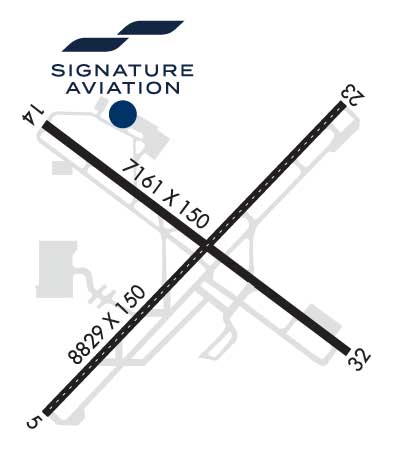
| Lat: N 4256.4 Long: W 07843.8 Elev: 727 Var: +11 Longest Runway: 8829 | ||
| Clr Del: 124.7 Dept. ATIS: 135.35 Arr. ATIS: 135.35 Ground: 133.2 Tower: 120.5 | ||
| ||||||||||||||||||||||||||||||||||||||||||||||||||||||||||||||
| ||||||||||||||||||||||||||||||||||||||||||||||||||||||||||||||
| ||||||||||||||||||||||||||||||||||||||||||||||||||||||||||||||
| Rwy | Rwy | |||||||
| 8829x150 | 8294' | 108.50 - 054° | 8829x150 | 8104' | 111.30 - 234° | |||
| 7161x150 | 6841' | 7161x150 | 6441' | 109.95 - 317° | ||||
| Runway ID | Single Wheel | Double Wheel | Double Tandem Wheel | Dual Double Wheel |
| 05/23 | 120,000 | 250,000 | 550,000 | 1,120,000 |
| 14/32 | 120,000 | 250,000 | 489,000 | 1,016,000 |
| These numbers are Advisory and are not limits. The Airport Manager should have more accurate Weight Limits | ||||
 Airport Diagram might not be current. | |
| Facility Name: | BUFFALO NIAGARA INTL |
| City Name: | BUFFALO |
| County: | ERIE |
| State abbrev: | NY |
| State Name: | NEW YORK |
| Ownership: | PUBLICLY OWNED |
| Use: | OPEN TO THE PUBLIC |
| Owner's Name: | NIAGARA FRONTIER TRAN AUTH |
| Address: | 181 ELLICOTT ST, PO BOX 5008 |
| BUFFALO, NY 14205 | |
| Owner's Phone: | 716-855-7300 |
| Manager's Name: | WILLIAM VANECEK |
| Address: | 4200 GENESEE ST |
| BUFFALO, NY 14225 | |
| Phone: | (716) 630-6030 |
| FAA Region: | EASTERN |
| FAA Field Office: | NYC |
| Date | Sunrise | Sunset |
|---|---|---|
| 09/24/21 Friday | 7:04 | 19:09 |
| 09/25/21 Saturday | 7:05 | 19:07 |
| 09/26/21 Sunday | 7:06 | 19:06 |
| 09/27/21 Monday | 7:07 | 19:04 |
| 09/28/21 Tuesday | 7:09 | 19:02 |
| 09/29/21 Wednesday | 7:10 | 19:00 |
| 09/30/21 Thursday | 7:11 | 18:58 |
| 10/01/21 Friday | 7:12 | 18:57 |
| 10/02/21 Saturday | 7:13 | 18:55 |
| 10/03/21 Sunday | 7:14 | 18:53 |
| 10/04/21 Monday | 7:15 | 18:51 |
| 10/05/21 Tuesday | 7:16 | 18:50 |
| 10/06/21 Wednesday | 7:18 | 18:48 |
| 10/07/21 Thursday | 7:19 | 18:46 |
| Airport Attendance Schedule | CONTINUOUS |
| Airport Status | OPERATIONAL (This Status can change at any time - please check NOTAMS) |
| Airport Lighting Schedule | |
| Airport Storage Available | Tie Downs, Hanger |
| Extra Services Available | Air Freight, Air Ambulance, Avionics, Cargo Handling, Charter, Flight Instruction, Aircraft Rental, Aircraft Sales, Annual Surveying |
| Wind Indicator | YES - (lighted) |
| Control Tower | YES |
| CTAF Frequency | |
| Unicom Frequency | |
| Rotating Beacon Color | CLEAR-GREEN (Light Land Airport) |
| Segmented Circle | NO |
| Landing Fee | YES |
| Airport Inspected | FEDERAL - performed by FAA AIRPORTS FIELD PERSONNEL |
| Inspection Date | 06/10/2019 |
| Type of Fuel Available | Grade 100LL, JET A (freeze point -40C) |
| Airframe Repair Service | MAJOR |
| Power Plant Repair Service | MAJOR |
| Latitude | N4256.4 |
| Longitude | W07843.8 (ESTIMATED) |
| Arpt Elevation | 726ft (SURVEYED) |
| Magnetic Variation | 11W |
| 5 miles E | of BUFFALO |
| Traffic Pattern Altitude | |
| Sectional Chart | DETROIT |
| Operations (Reported) | Yearly | Avg. Daily |
|---|---|---|
| General Aviation Transient | 4762 | 13 |
| General Aviation Local | 7612 | 21 |
| Air Taxi | 18537 | 51 |
| Commerical | 50653 | 139 |
| Commuter | 0 | 0 |
| Military | 455 | 1 |
| Aircraft based on Field | |
|---|---|
| General Aviation Singles | 16 |
| General Aviation Multi | 0 |
| Jet Aircraft | 9 |
| General Aviation Helicopters | 0 |
| Military Aircraft | 0 |
| Gliders | 0 |
| Ultralights | 0 |
| FSS on field | NO |
| FSS tie-in | BUFFALO |
| FSS Phone | 1-800-WX-BRIEF |
| Who issues Notams | BUF |
| Notam D service at airport | YES |
| ARTCC Name | CLEVELAND |
| Airport Certification | AIRPORT RECEIVING SCHEDULED AIR CARRIER SERVICE FROM CARRIERS CERTIFICATED BY THE CIVIL AERONAUTICS BOARD; ARFF INDEX D EQUIPMENT COVERAGE PROVIDED. |
| Aircraft Rescue & Firefighting Index | AIRPORT HAS A CERTIFICATE UNDER CFR PART 139 |
| Airport of Entry | No |
| Custom Landing Rights | YES |
| Joint Civil/Military | No |
| Military Landing rights | YES |
| NATIONAL PLAN OF INTEGRATED AIRPORT SYSTEMS (NPIAS) |
| GRANT AGREEMENTS UNDER FAAP/ADAP/AIP |
| SURPLUS PROPERTY AGREEMENT UNDER PUBLIC LAW 289 |
| ASSURANCES PURSUANT TO TITLE VI, CIVIL RIGHTS ACT OF 1964 |
| HEAVY CONCENTRATION OF GULLS; BLACKBIRDS & STARLINGS UP TO 5000 FT ON & INVOF ARPT. |
| DEER ON & INVOF ARPT. |
| FOR FBO SVCS CTC 131.75; FOR CARGO SVCS CTC 122.95. |
| TWY 'A' SOUTHWEST RUNUP AREA/HOLDING BAY MARKED DESIGN GROUP 3 ACFT (GENERALLY B727 OR SMALLER) UNAVAILABLE DESIGN GROUP 4 (INCLUDES BUT NOT LIMITED TO B757 DC8). |
| TWY 'K1' CLSD 2100-0800 DAILY. |
| TWY P BTN APCH END RWY 14 AND TWY P2 CLSD TO ACFT WINGSPAN MORE THAN 117 FT. |
Airport Communications & Frequencies:
| |||||||||||||||||||||||||||||||||||||||||||||||||
| Runway: 05 | Runway: 23 | ||
| Mag heading: | 55° | Mag heading: | 235° |
| Rwy Slope: | .60% Up | Rwy Slope: | -.60% Down |
| Approach: | ILS | Approach: | ILS |
| Pattern: | Left Traffic | Pattern: | Left Traffic |
| Markings: | PRECISION INSTRUMENT | Markings: | PRECISION INSTRUMENT |
| Marking Condition: | GOOD | Marking Condition: | GOOD |
| Arresting Dev: | Arresting Dev: | ||
| Lat & Long: | N4255.9 W07844.5 | Lat. & Long.: | N4256.9 W07843.1 |
| Elev: | 674.1 ft. MSL | Elev: | 726.8 ft. MSL |
| TCH: | 49 ft. AGL | TCH: | 52 ft. AGL |
| Visual Glide Path: | 3.00 degrees | Visual Glide Path: | 3.00 degrees |
| Displaced Threshold: | 535 feet | Displaced Threshold: | 725 feet |
| Touchdown Zone: | YES | Touchdown Zone: | YES |
| Touchdown Elev.: | 707.7 feet | Touchdown Elev.: | 726.0 feet |
| Visual Glide Slope: | 4-Light PAPI on LEFT side of Runway | Visual Glide Slope: | 4-Light PAPI on RIGHT side of Runway |
| RVR Equipment: | TOUCHDOWN-MIDFIELD-ROLLOUT | RVR Equipment: | TOUCHDOWN-MIDFIELD-ROLLOUT |
| RVV Equipment: | NO | RVV Equipment: | NO |
| Approach Lights: | MALSR - 1,400 foot medium intensity approach lighting system with runway alignment indicator lights | Approach Lights: | ALSF2 - standard 2,400 foot high intensity approach lighting system with sequenced flashers, Category II or III |
| REIL: | NO | REIL: | NO |
| Centerline Lights: | YES | Centerline Lights: | YES |
| Touchdown lights: | YES | Touchdown lights: | YES |
| Runway Category: | Precision Instrument Runway | Runway Category: | Precision Instrument Runway |
| Declared Distances: | TORA:8829' TODA:8829' ASDA:8104' LDA:7569' | Declared Distances: | TORA:8829' TODA:8829' ASDA:8294' LDA:7569' |
| Obstructions: | BLDG | Obstructions: | TREE |
| Marked: | NOT Marked/Lighted | Marked: | NOT Marked/Lighted |
| Clearance slope: | 10:1; RWY 05 APCH SLOPE 45:1 TO DSPLCD THLD. | Clearance slope: | 32:1 |
| Obstruction height: | 21 feet AGL | Obstruction height: | 29 feet AGL |
| Dist. from runway: | 413 feet | Dist. from runway: | 1155 feet |
| Centerline offset: | 532 right of centerline | Centerline offset: | 360 feet right of centerline |
| Comments: | RWY 05 HAS +3 FT POLE LIGHT POLE 59 FT FM RWY END, 497 FT RIGHT. | Comments: |
| Runway: 14 | Runway: 32 | ||
| Mag heading: | 138° | Mag heading: | 318° |
| Rwy Slope: | .14% Up | Rwy Slope: | -.14% Down |
| Approach: | Approach: | ILS/DME | |
| Pattern: | Left Traffic | Pattern: | Left Traffic |
| Markings: | NONPRECISION INSTRUMENT | Markings: | PRECISION INSTRUMENT |
| Marking Condition: | GOOD | Marking Condition: | GOOD |
| Arresting Dev: | Arresting Dev: | ||
| Lat & Long: | N4256.8 W07844.5 | Lat. & Long.: | N4256.1 W07843.2 |
| Elev: | 699.1 ft. MSL | Elev: | 708.8 ft. MSL |
| TCH: | 53 ft. AGL | TCH: | 54 ft. AGL |
| Visual Glide Path: | 3.00 degrees | Visual Glide Path: | 3.00 degrees |
| Displaced Threshold: | 320 feet | Displaced Threshold: | 720 feet |
| Touchdown Zone: | YES | Touchdown Zone: | YES |
| Touchdown Elev.: | 710.2 feet | Touchdown Elev.: | 713.2 feet |
| Visual Glide Slope: | 4-Light PAPI on LEFT side of Runway | Visual Glide Slope: | 4-Light PAPI on LEFT side of Runway |
| RVR Equipment: | RVR Equipment: | ||
| RVV Equipment: | NO | RVV Equipment: | NO |
| Approach Lights: | Approach Lights: | MALSR - 1,400 foot medium intensity approach lighting system with runway alignment indicator lights | |
| REIL: | YES | REIL: | NO |
| Centerline Lights: | NO | Centerline Lights: | NO |
| Touchdown lights: | NO | Touchdown lights: | NO |
| Runway Category: | Runway with a Non-precision Approach having visibility minimums greater than 3/4 mile | Runway Category: | Precision Instrument Runway |
| Declared Distances: | TORA:7161' TODA:7161' ASDA:6441' LDA:6121' | Declared Distances: | TORA:7161' TODA:7161' ASDA:6841' LDA:6121' |
| Obstructions: | TREE | Obstructions: | SIGN |
| Marked: | NOT Marked/Lighted | Marked: | NOT Marked/Lighted |
| Clearance slope: | 13:1; RWY 14 APCH SLOPE 29:1 TO DSPLCD THLD. | Clearance slope: | 1:1 |
| Obstruction height: | 31 feet AGL | Obstruction height: | 14 feet AGL |
| Dist. from runway: | 608 feet | Dist. from runway: | 200 feet |
| Centerline offset: | 535 right of centerline | Centerline offset: | 429 feet left of centerline |
| Comments: | Comments: | +7 FT OBSTRUCTION LIGHTED FENCE , 0 FT FM RWY END, 480 FT LEFT. |
Thanks for using FltPlan.com
all rights reserved © 1999-2021 by Flight Plan LLC