
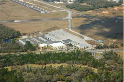
| BROOKSVILLE-TAMPA BAY RGNL BROOKSVILLE FL |
| |
| Lat: N 2828.4 Long: W 08227.4 Elev: 76 Var: +04 Longest Runway: 7001 | ||
| Clr Del: 119.12 TW CLD AWOS: 134.72 Ground: 121.4 Tower: 118.55 | ||
| ||||||||||||||||||||||||||||||||||||||||||||
| ||||||||||||||||||||||||||||||||||||||||||||
| ||||||||||||||||||||||||||||||||||||||||||||
| ||||||||||||||||||||||||||||||||||||||||||||
| Rwy | Rwy | |||||||
| 4200x150 | 4200' | 4200x150 | 4200' | |||||
| 7001x150 | 7001' | 110.75 - 094° | 7001x150 | 7001' | ||||
| Runway ID | Single Wheel | Double Wheel | Double Tandem Wheel | Dual Double Wheel |
| 03/21 | 50,000 | 75,000 | 135,000 | N/A |
| 09/27 | 90,000 | 130,000 | 230,000 | N/A |
| These numbers are Advisory and are not limits. The Airport Manager should have more accurate Weight Limits | ||||
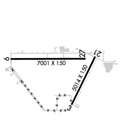 Airport Diagram might not be current. | |
| Facility Name: | BROOKSVILLE-TAMPA BAY RGNL |
| City Name: | BROOKSVILLE |
| County: | HERNANDO |
| State abbrev: | FL |
| State Name: | FLORIDA |
| Ownership: | PUBLICLY OWNED |
| Use: | OPEN TO THE PUBLIC |
| Owner's Name: | HERNANDO COUNTY BOCC |
| Address: | 20 NORTH MAIN STREET, ROOM 263, M 263 |
| BROOKSVILLE, FL 34601 | |
| Owner's Phone: | 352-754-4000 |
| Manager's Name: | STEVE MILLER |
| Address: | 15800 FLIGHT PATH DR |
| BROOKSVILLE, FL 34604 | |
| Phone: | 352-540-6342 |
| FAA Region: | SOUTHERN |
| FAA Field Office: | ORL |
| Date | Sunrise | Sunset |
|---|---|---|
| 06/28/26 Sunday | 6:35 | 20:31 |
| 06/29/26 Monday | 6:35 | 20:31 |
| 06/30/26 Tuesday | 6:35 | 20:31 |
| 07/01/26 Wednesday | 6:36 | 20:31 |
| 07/02/26 Thursday | 6:36 | 20:31 |
| 07/03/26 Friday | 6:37 | 20:31 |
| 07/04/26 Saturday | 6:37 | 20:31 |
| 07/05/26 Sunday | 6:37 | 20:31 |
| 07/06/26 Monday | 6:38 | 20:31 |
| 07/07/26 Tuesday | 6:38 | 20:31 |
| 07/08/26 Wednesday | 6:39 | 20:31 |
| 07/09/26 Thursday | 6:39 | 20:31 |
| 07/10/26 Friday | 6:40 | 20:30 |
| 07/11/26 Saturday | 6:40 | 20:30 |
| Airport Attendance Schedule | 7 Days A Week 0700-1800 |
| Airport Status | OPERATIONAL (This Status can change at any time - please check NOTAMS) |
| Airport Lighting Schedule | DUSK-2200. MALSR RWY 9; MIRL RWY 03/21 & 09/27 PRESET LOW INTST DUSK-2200, TO INCR INTST AND ACTVT AFTER 2200 - CTAF. |
| Airport Storage Available | Tie Downs, Hanger |
| Extra Services Available | Air Ambulance, Avionics, Charter, Flight Instruction, Aircraft Rental, Aircraft Sales, Annual Surveying |
| Wind Indicator | YES - (lighted) |
| Control Tower | YES |
| CTAF Frequency | 118.550 |
| Unicom Frequency | 123.000 |
| Rotating Beacon Color | WG |
| Segmented Circle | YES |
| Landing Fee | NO |
| Airport Inspected | STATE - performed by STATE AERONAUTICAL PERSONNEL |
| Inspection Date | 11/07/2025 |
| Type of Fuel Available | Grade 100LL, JET A (freeze point -40C) |
| Airframe Repair Service | MAJOR |
| Power Plant Repair Service | MAJOR |
| Latitude | N2828.4 |
| Longitude | W08227.4 (ESTIMATED) |
| Arpt Elevation | 76ft (SURVEYED) |
| Magnetic Variation | 04W |
| 6 miles SW | of BROOKSVILLE |
| Traffic Pattern Altitude | |
| Sectional Chart | JACKSONVILLE |
| Operations (Reported) | Yearly | Avg. Daily |
|---|---|---|
| General Aviation Transient | 0 | 0 |
| General Aviation Local | 0 | 0 |
| Air Taxi | 0 | 0 |
| Commerical | 0 | 0 |
| Commuter | 0 | 0 |
| Military | 0 | 0 |
| Aircraft based on Field | |
|---|---|
| General Aviation Singles | 0 |
| General Aviation Multi | 0 |
| Jet Aircraft | 0 |
| General Aviation Helicopters | 0 |
| Military Aircraft | 0 |
| Gliders | 0 |
| Ultralights | 0 |
| FSS on field | NO |
| FSS tie-in | SAINT PETERSBURG |
| FSS Phone | 1-800-WX-BRIEF |
| Who issues Notams | BKV |
| Notam D service at airport | YES |
| ARTCC Name | JACKSONVILLE |
| Airport Certification | |
| Aircraft Rescue & Firefighting Index | None |
| Airport of Entry | No |
| Custom Landing Rights | No |
| Joint Civil/Military | No |
| Military Landing rights | YES |
| NATIONAL PLAN OF INTEGRATED AIRPORT SYSTEMS (NPIAS) |
| GRANT AGREEMENTS UNDER FAAP/ADAP/AIP |
| SURPLUS PROPERTY AGREEMENT UNDER PUBLIC LAW 289 |
| SURPLUS PROPERTY AGREEMENT UNDER REGULATION 16-WAA |
| ASSURANCES PURSUANT TO TITLE VI, CIVIL RIGHTS ACT OF 1964 |
| WILDLIFE ON AND INVOF ARPT. |
| FOR CD IF UNA TO CTC ON FSS FREQ, CTC TAMPA APCH AT 813-878-2528. |
| PPR 352-797-5813. PRK RAMP 42.525. |
| RWY 03/2 1 LONG AND TRANSVERSE CRACKING PRODUCING LOOSE AGGREGATE. |
Airport Communications & Frequencies:
| ||||||||||||||||||||||||
| Runway: 03 | Runway: 21 | ||
| Mag heading: | 30° | Mag heading: | 210° |
| Rwy Slope: | .02% Up | Rwy Slope: | -.02% Down |
| Approach: | Approach: | ||
| Pattern: | Left Traffic | Pattern: | Left Traffic |
| Markings: | NONPRECISION INSTRUMENT | Markings: | NONPRECISION INSTRUMENT |
| Marking Condition: | GOOD | Marking Condition: | GOOD |
| Arresting Dev: | Arresting Dev: | ||
| Lat & Long: | N2827.8 W08227.2 | Lat. & Long.: | N2828.5 W08226.8 |
| Elev: | 67.3 ft. MSL | Elev: | 68.0 ft. MSL |
| TCH: | 40 ft. AGL | TCH: | 44 ft. AGL |
| Visual Glide Path: | 3.00 degrees | Visual Glide Path: | 3.00 degrees |
| Displaced Threshold: | No | Displaced Threshold: | No |
| Touchdown Zone: | YES | Touchdown Zone: | YES |
| Touchdown Elev.: | 67.7 feet | Touchdown Elev.: | 68.9 feet |
| Visual Glide Slope: | 4-Light PAPI on LEFT side of Runway | Visual Glide Slope: | 4-Light PAPI on LEFT side of Runway |
| RVR Equipment: | RVR Equipment: | ||
| RVV Equipment: | NO | RVV Equipment: | NO |
| Approach Lights: | Approach Lights: | ||
| REIL: | NO | REIL: | NO |
| Centerline Lights: | NO | Centerline Lights: | NO |
| Touchdown lights: | NO | Touchdown lights: | NO |
| Runway Category: | Runway with a Non-precision Approach having visibility minimums greater than 3/4 mile | Runway Category: | Runway with a Non-precision Approach having visibility minimums greater than 3/4 mile |
| Declared Distances: | Declared Distances: | ||
| Obstructions: | TREES | Obstructions: | TREES |
| Marked: | NOT Marked/Lighted | Marked: | NOT Marked/Lighted |
| Clearance slope: | 18:1 | Clearance slope: | 34:1 |
| Obstruction height: | 51 feet AGL | Obstruction height: | 81 feet AGL |
| Dist. from runway: | 1155 feet | Dist. from runway: | 2960 feet |
| Centerline offset: | 250 left of centerline | Centerline offset: | |
| Comments: | Comments: |
| Runway: 09 | Runway: 27 | ||
| Mag heading: | 94° | Mag heading: | 274° |
| Rwy Slope: | -.01% Down | Rwy Slope: | .01% Up |
| Approach: | ILS/DME | Approach: | |
| Pattern: | Left Traffic | Pattern: | Left Traffic |
| Markings: | PRECISION INSTRUMENT | Markings: | NONPRECISION INSTRUMENT |
| Marking Condition: | GOOD | Marking Condition: | GOOD |
| Arresting Dev: | Arresting Dev: | ||
| Lat & Long: | N2828.6 W08228.2 | Lat. & Long.: | N2828.6 W08226.9 |
| Elev: | 70.0 ft. MSL | Elev: | 69.1 ft. MSL |
| TCH: | 58 ft. AGL | TCH: | 53 ft. AGL |
| Visual Glide Path: | 3.00 degrees | Visual Glide Path: | 3.00 degrees |
| Displaced Threshold: | No | Displaced Threshold: | No |
| Touchdown Zone: | YES | Touchdown Zone: | YES |
| Touchdown Elev.: | 76.1 feet | Touchdown Elev.: | 69.2 feet |
| Visual Glide Slope: | 4-Light PAPI on LEFT side of Runway | Visual Glide Slope: | 4-Light PAPI on LEFT side of Runway |
| RVR Equipment: | RVR Equipment: | ||
| RVV Equipment: | NO | RVV Equipment: | NO |
| Approach Lights: | MALSR - 1,400 foot medium intensity approach lighting system with runway alignment indicator lights | Approach Lights: | |
| REIL: | NO | REIL: | NO |
| Centerline Lights: | NO | Centerline Lights: | NO |
| Touchdown lights: | NO | Touchdown lights: | NO |
| Runway Category: | Precision Instrument Runway | Runway Category: | Runway with a Non-precision Approach having visibility minimums greater than 3/4 mile |
| Declared Distances: | Declared Distances: | ||
| Obstructions: | TREES | Obstructions: | TREES |
| Marked: | NOT Marked/Lighted | Marked: | NOT Marked/Lighted |
| Clearance slope: | 46:1 | Clearance slope: | 34:1 |
| Obstruction height: | 63 feet AGL | Obstruction height: | 99 feet AGL |
| Dist. from runway: | 3135 feet | Dist. from runway: | 3540 feet |
| Centerline offset: | 385 right of centerline | Centerline offset: | 75 feet right of centerline |
| Comments: | Comments: |
Thanks for using FltPlan.com
all rights reserved © 1999-2026 by Flight Plan LLC