NOTICE: Information listed below may not be current.Airport Ident: SBGR
| Airport Name: GUARULHOS GOV ANDRE FRANCO MONTOURO, Brazil
Location: Sao Paulo
Latitude: S2325.9 Longitude: W04628.2
Field Elevation: 2459' Variation: W20° as of 01/06
Time Zone: UTC-3(-2DT)
Daylight Savings: OF
Customs: Airport Of Entry
|
|
| DISTANCE from: | KTEB to SBGR = 4152 nm
| KMIA to SBGR = 3546 nm
| KORD to SBGR = 4547 nm
| KDAL to SBGR = 4439 nm
| KSEA to SBGR = 5886 nm
| KLAX to SBGR = 5352 nm
|
|
| AIRPORT TYPE: | | Active, joint (civil and military) use. Airports jointly controlled, used and/or operated by both civil and military agencies. The military agencies must be permanent operational flight line type tenants, with or without aircraft stationed on the airport. Minimum facilities are available which include: control tower (or some similar control system, such as a Flight Service Station which issues clearances and advisories when there is no tower or the tower is not in operation), lighting (may be flare pots, etc.), petrol, oils and lubricants (POL), and facilities for organizational maintenance or better. |
|
Rotating Beacon: YES
|
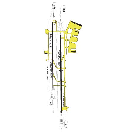
| RUNWAY INFORMATION: | Runway Ident: 27L/09R
Runway Length: 9843
Runway Width: 148
Runway Surface: ASPHALT, ASPHALTIC CONCRETE, TAR MACADAM, OR BITUMEN BOUND MACADAM (INCLUDING ANY OF THESE SURFACE TYPES WITH CONCRETE ENDS).
Runway PCN Rating: 085FBWT - Flexible, Subgrade-MEDIUM, Tire Pressure-HIGH NO LIMIT
Runway PCN Evaluation Method: Technical Evaluation.
Runway Open: YES
| Runway 27L Information
Runway True Heading: 254°
Takeoff Distance Available: 10043
Landing Distance Available: 9843
Runway Latitude: S2325.9
Runway Longitude: W04627.5
Runway Elevation: 2449'
Runway Slope: .1°
Runway TDZE: 2449'
Runway Lighting: SF, CL, HIRL, REIL, ALSF-1, PAPI
| Runway 09R Information
Runway True Heading: 74°
Takeoff Distance Available: 10043
Landing Distance Available: 9843
Runway Latitude: S2326.3
Runway Longitude: W04629.2
Runway Elevation: 2459'
Runway Slope: -.1°
Runway TDZE: 2459
Runway Lighting: SF, TDZL, CL, HIRL, REIL, ALSF-2, PAPI
|
Runway Ident: 27R/09L
Runway Length: 12140
Runway Width: 148
Runway Surface: ASPHALT, ASPHALTIC CONCRETE, TAR MACADAM, OR BITUMEN BOUND MACADAM (INCLUDING ANY OF THESE SURFACE TYPES WITH CONCRETE ENDS).
Runway PCN Rating: 085FBWT - Flexible, Subgrade-MEDIUM, Tire Pressure-HIGH NO LIMIT
Runway PCN Evaluation Method: Technical Evaluation.
Runway Open: YES
| Runway 27R Information
Runway True Heading: 254°
Runway Displaced Threshold: 29'
Takeoff Distance Available: 12340
Landing Distance Available: 11850
Runway Latitude: S2325.5
Runway Longitude: W04626.9
Runway Elevation: 2441'
Runway Slope: .1°
Runway TDZE: 2441'
Runway Lighting: SF, CL, HIRL, REIL, ALSF-1, PAPI
| Runway 09L Information
Runway True Heading: 74°
Runway Displaced Threshold: 19.5
Takeoff Distance Available: 12340
Landing Distance Available: 11945
Runway Latitude: S2326.1
Runway Longitude: W04629.0
Runway Elevation: 2459'
Runway Slope: -.1°
Runway TDZE: 2459
Runway Lighting: SF, TDZL, CL, HIRL, REIL, ALSF-2, PAPI
|
|
|
| ILS INFORMATION | Rwy 09R ILS Information
Glide Slope (2.92°)
Outer Marker
Localizer (111.5)
| Rwy 27L ILS Information
Glide Slope (3°)
Outer Marker (BONSUCESSO)
Localizer (111.1) (CAT 1)
| Rwy 09L ILS Information
Glide Slope (2.97°)
Outer Marker
Localizer (110.7)
| Rwy 27R ILS Information
Glide Slope (3°)
Localizer (111.9) (CAT 1) (GUARULHOS)
|
|
COMMUNICATION INFORMATION
APPROACH CONTROL - SAO PAULO APP
119.8 120.05 129.5
AUTOMATIC TERMINAL INFORMATION SERVICE - ATIS (Opr 0900-0300Z.)
127.75
CLEARANCE DELIVERY - CLNC DEL
121.0
GROUND CONTROL - GND
121.7 126.9
OPERATIONS - SAO PAULO OPS
122.5
TOWER - TWR
118.4 132.75 135.2
|
OPERATING HOURS
AUTOMATIC TERMINAL INFORMATION SERVICE - Opr 0900-0300Z.
|
AIRPORT NAVAIDS
BCO - BONSUCESSO (VOR-DME) - Bearing: 272° Distance: 4.9 nm
PER - PERUS (NDB) - Bearing: 112° Distance: 15.8 nm
|