NOTICE: Information listed below may not be current.Airport Ident: SBCT
| Airport Name: AFONSO PENA, Brazil
Location: Curitiba
Latitude: S2531.7 Longitude: W04910.5
Field Elevation: 2988' Variation: W18° as of 01/06
Time Zone: UTC-3(-2DT)
Daylight Savings: OF
Customs: Airport Of Entry
|
|
| DISTANCE from: | KTEB to SBCT = 4217 nm
| KMIA to SBCT = 3568 nm
| KORD to SBCT = 4584 nm
| KDAL to SBCT = 4436 nm
| KSEA to SBCT = 5884 nm
| KLAX to SBCT = 5315 nm
|
|
| AIRPORT TYPE: | | Active civil airports controlled and operated by civil authorities primarily for use by civil aircraft, although military may have landing privileges and/or contract rights. Minimum facilities are available which include: control tower (or some similar control system, such as a Flight Service Station which issues clearances and advisories when there is no tower or the tower is not in operation), lighting (may be flare pots, etc.), petrol, oils and lubricants (POL), and facilities for organizational maintenance or better. |
|
Rotating Beacon: YES
|
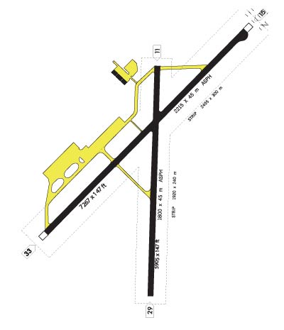
| RUNWAY INFORMATION: | Runway Ident: 29 /11
Runway Length: 5905
Runway Width: 148
Runway Surface: ASPHALT, ASPHALTIC CONCRETE, TAR MACADAM, OR BITUMEN BOUND MACADAM (INCLUDING ANY OF THESE SURFACE TYPES WITH CONCRETE ENDS).
Runway PCN Rating: 033FAXT - Flexible, Subgrade-HIGH, Tire Pressure-MEDIUM LIMITED TO 217 PSI
Runway PCN Evaluation Method: Technical Evaluation.
Runway Open: YES
| Runway 29 Information
Runway True Heading: 272°
Takeoff Distance Available: 5905
Landing Distance Available: 5905
Runway Latitude: S2531.7
Runway Longitude: W04909.7
Runway Elevation: 2964'
Runway Slope: .2°
Runway TDZE:
Runway Lighting: LIRL
| Runway 11 Information
Runway True Heading: 92°
Takeoff Distance Available: 5905
Landing Distance Available: 5905
Runway Latitude: S2531.7
Runway Longitude: W04910.8
Runway Elevation: 2974'
Runway Slope: -.2°
Runway TDZE: N/A
Runway Lighting: LIRL, VASI
|
Runway Ident: 33 /15
Runway Length: 7267
Runway Width: 148
Runway Surface: ASPHALT, ASPHALTIC CONCRETE, TAR MACADAM, OR BITUMEN BOUND MACADAM (INCLUDING ANY OF THESE SURFACE TYPES WITH CONCRETE ENDS).
Runway PCN Rating: 042FAXT - Flexible, Subgrade-HIGH, Tire Pressure-MEDIUM LIMITED TO 217 PSI
Runway PCN Evaluation Method: Technical Evaluation.
Runway Open: YES
| Runway 33 Information
Runway True Heading: 315°
Takeoff Distance Available: 7457
Landing Distance Available: 7267
Runway Latitude: S2532.2
Runway Longitude: W04910.0
Runway Elevation: 2987'
Runway Slope: -.2°
Runway TDZE:
Runway Lighting: LIRL
| Runway 15 Information
Runway True Heading: 135°
Takeoff Distance Available: 7452
Landing Distance Available: 7267
Runway Latitude: S2531.3
Runway Longitude: W04911.0
Runway Elevation: 2972'
Runway Slope: .2°
Runway TDZE: N/A
Runway Lighting: LIRL, VASI
|
|
|
| ILS INFORMATION | Rwy 15 ILS Information
Glide Slope (3.04°)
Middle Marker
Outer Marker
Localizer (109.3)
|
|
COMMUNICATION INFORMATION
APPROACH CONTROL - CURITIBA APP
119.95 120.65 129.55
AUTOMATIC TERMINAL INFORMATION SERVICE - ATIS
127.8
GROUND CONTROL - GND
121.9
TOWER - CURITIBA TWR
118.55
|
AIRPORT NAVAIDS
CRT - CURITIBA (NDB) - ON FIELD
CTB - CURITIBA (VOR-DME) - ON FIELD
PNH - PINHAIS (NDB) - Bearing: 332° Distance: 6.6 nm
|