NOTICE: Information listed below may not be current.Airport Ident: SBCG
| Airport Name: CAMPO GRANDE, Brazil
Latitude: S2028.1 Longitude: W05440.4
Field Elevation: 1833' Variation: W16° as of 01/06
Time Zone: UTC-4(-3DT)
Daylight Savings: OF
Customs: Airport Of Entry
|
|
| DISTANCE from: | KTEB to SBCG = 3835 nm
| KMIA to SBCG = 3151 nm
| KORD to SBCG = 4176 nm
| KDAL to SBCG = 4009 nm
| KSEA to SBCG = 5457 nm
| KLAX to SBCG = 4887 nm
|
|
| AIRPORT TYPE: | | Active, joint (civil and military) use. Airports jointly controlled, used and/or operated by both civil and military agencies. The military agencies must be permanent operational flight line type tenants, with or without aircraft stationed on the airport. Minimum facilities are available which include: control tower (or some similar control system, such as a Flight Service Station which issues clearances and advisories when there is no tower or the tower is not in operation), lighting (may be flare pots, etc.), petrol, oils and lubricants (POL), and facilities for organizational maintenance or better. |
|
Rotating Beacon: YES
|
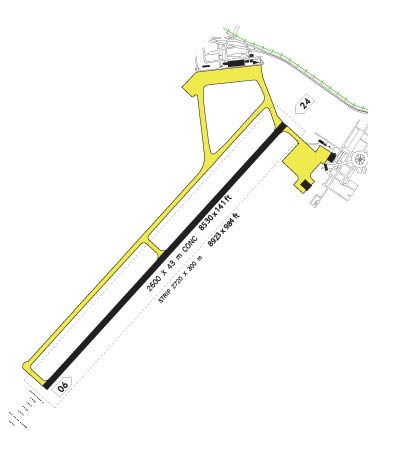
| RUNWAY INFORMATION: | Runway Ident: 24 /06
Runway Length: 8530
Runway Width: 141
Runway Surface: ASPHALT, ASPHALTIC CONCRETE, TAR MACADAM, OR BITUMEN BOUND MACADAM (INCLUDING ANY OF THESE SURFACE TYPES WITH CONCRETE ENDS).
Runway PCN Rating: 048FBXT - Flexible, Subgrade-MEDIUM, Tire Pressure-MEDIUM LIMITED TO 217 PSI
Runway PCN Evaluation Method: Technical Evaluation.
Runway Open: YES
| Runway 24 Information
Runway True Heading: 221°
Takeoff Distance Available: 8720
Landing Distance Available: 8530
Runway Latitude: S2027.6
Runway Longitude: W05439.9
Runway Elevation: 1833'
Runway Slope: -.4°
Runway TDZE:
Runway Lighting: LIRL, PAPI
| Runway 06 Information
Runway True Heading: 41°
Takeoff Distance Available: 8722
Landing Distance Available: 8530
Runway Latitude: S2028.7
Runway Longitude: W05440.8
Runway Elevation: 1801'
Runway Slope: .4°
Runway TDZE: 1801
Runway Lighting: LIRL, MALSR, PAPI
|
|
|
| ILS INFORMATION | Rwy 06 ILS Information
Glide Slope (3°)
Middle Marker
Outer Marker
Localizer (110.3)
|
|
COMMUNICATION INFORMATION
APPROACH CONTROL - APP
120.2
GROUND CONTROL - GND
121.9
OPERATIONS - OPS
122.5
TOWER - TWR
118.1
|
AIRPORT NAVAIDS
CGR - CAMPO GRANDE (VOR-DME) - ON FIELD
CGR - CAMPO GRANDE (NDB) - Bearing: 58° Distance: 5 nm
IG - SOJA (NDB) - Bearing: 43° Distance: 1.4 nm
PP - MARACA (NDB) - Bearing: 229° Distance: 4.3 nm
|