NOTICE: Information listed below may not be current.Airport Ident: SBCF
| Airport Name: TANCREDO NEVES INTL, Brazil
Location: Belo Horizonte
Latitude: S1938.0 Longitude: W04358.1
Field Elevation: 2715' Variation: W22° as of 01/06
Time Zone: UTC-3(-2DT)
Daylight Savings: OF
Customs: Airport Of Entry
|
|
| DISTANCE from: | KTEB to SBCF = 3998 nm
| KMIA to SBCF = 3451 nm
| KORD to SBCF = 4426 nm
| KDAL to SBCF = 4370 nm
| KSEA to SBCF = 5809 nm
| KLAX to SBCF = 5324 nm
|
|
| AIRPORT TYPE: | | Active civil airports controlled and operated by civil authorities primarily for use by civil aircraft, although military may have landing privileges and/or contract rights. Minimum facilities are available which include: control tower (or some similar control system, such as a Flight Service Station which issues clearances and advisories when there is no tower or the tower is not in operation), lighting (may be flare pots, etc.), petrol, oils and lubricants (POL), and facilities for organizational maintenance or better. |
|
Rotating Beacon: YES
|
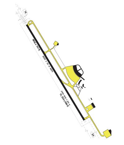
| RUNWAY INFORMATION: | Runway Ident: 34 /16
Runway Length: 9843
Runway Width: 148
Runway Surface: ASPHALT, ASPHALTIC CONCRETE, TAR MACADAM, OR BITUMEN BOUND MACADAM (INCLUDING ANY OF THESE SURFACE TYPES WITH CONCRETE ENDS).
Runway PCN Rating: 060FAWT - Flexible, Subgrade-HIGH, Tire Pressure-HIGH NO LIMIT
Runway PCN Evaluation Method: Technical Evaluation.
Runway Open: YES
| Runway 34 Information
Runway True Heading: 319°
Takeoff Distance Available: 10043
Landing Distance Available: 9843
Runway Latitude: S1938.6
Runway Longitude: W04357.6
Runway Elevation: 2712'
Runway Slope: 0°
Runway TDZE:
Runway Lighting: HIRL, REIL, PAPI
| Runway 16 Information
Runway True Heading: 139°
Takeoff Distance Available: 10043
Landing Distance Available: 9843
Runway Latitude: S1937.4
Runway Longitude: W04358.7
Runway Elevation: 2712'
Runway Slope: 0°
Runway TDZE: 2712
Runway Lighting: SF, HIRL, REIL, ALSF-1, PAPI
|
|
|
| ILS INFORMATION | Rwy 16 ILS Information
Glide Slope (3°)
Middle Marker
Outer Marker
Localizer (109.7)
|
|
COMMUNICATION INFORMATION
APPROACH CONTROL - BELO HORIZONTE APP
120.2 129.1 129.4 119.65
AUTOMATIC TERMINAL INFORMATION SERVICE - BELO HORIZONTE ATIS
127.45
CLEARANCE DELIVERY - CONFINS CLNC DEL
121.0
GROUND CONTROL - GND
121.9
OPERATIONS - BELO HORIZONTE OPS
122.5
TOWER - CONFINS TWR
118.2
|
AIRPORT NAVAIDS
CNF - CONFINS (VOR-DME) - Bearing: 157° Distance: 6.4 nm
|