
| PRS JUSCELINO KUBITSCHEK (BSB) BRASILIA DF |
| |
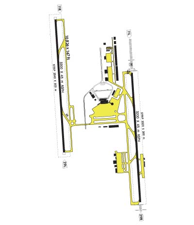
| Lat: S 1552.2 Long: W 04755.3 Elev: 3497 Var: +21 Longest Runway: 10499 | ||
| Dept. ATIS: 127.8 Arr. ATIS: 127.8 Ground: 121.8 Tower: 118.1 | ||
| |||||
| |||||
|
 |  |
| ||||
NOTICE: Information listed below may not be current.
| ||||||||||
| ||||||||||
| ||||||||||
| Rotating Beacon: YES | ||||||||||
| ||||||||||
| ||||||||||
| COMMUNICATION INFORMATION APPROACH CONTROL - BRASILIA APP 119.2 119.7 119.5 AUTOMATIC TERMINAL INFORMATION SERVICE - BRASILIA ATIS 127.8 CLEARANCE DELIVERY - BRASILIA CLNC DEL (Opr 0900-0100Z.) 121.8 GROUND CONTROL - GND 121.8 OPERATIONS - BRASILIA OPS 122.5 PILOT TO METRO SERVICE - BRASILIA METRO 132.6 132.4 TOWER - BRASILIA TWR 118.45 118.1 | ||||||||||
| OPERATING HOURS CLEARANCE DELIVERY - Opr 0900-0100Z. | ||||||||||
| INSTRUMENT APPROACHES VORDME RW11L VORDME RW29R ILS RW11L ILS/DME RW 29R NDB RW11L | ||||||||||
| APPROACH MINIMUMS VORDME RW11L CIRCL Approach Minimums Category A: 4140' MSL and 1600 METERS Category B: 4140' MSL and 1600 METERS Category C: 4140' MSL and 3200 METERS Category D: 4360' MSL and 4800 METERS Category E: NA VORDME RW11L S-11L Approach Minimums Category A: 4140' MSL and 800 METERS Category B: 4140' MSL and 800 METERS Category C: 4140' MSL and 2400 METERS Category D: 4140' MSL and 2800 METERS Category E: NA VORDME RW29R CIRCL Approach Minimums Category A: 4200' MSL and 1600 METERS Category B: 4200' MSL and 1600 METERS Category C: 4200' MSL and 3200 METERS Category D: 4360' MSL and 4800 METERS Category E: NA VORDME RW29R S-29R Approach Minimums Category A: 4200' MSL and 800 METERS Category B: 4200' MSL and 800 METERS Category C: 4200' MSL and 2400 METERS Category D: 4200' MSL and 2800 METERS Category E: NA ILS RW11L CIRCL Approach Minimums Category A: 4140' MSL and 1600 METERS Category B: 4140' MSL and 1600 METERS Category C: 4140' MSL and 3200 METERS Category D: 4360' MSL and 4800 METERS Category E: NA ILS RW11L S-ILS Approach Minimums Category A: 3650' MSL and 800 METERS Category B: 3650' MSL and 800 METERS Category C: 3650' MSL and 800 METERS Category D: 3650' MSL and 800 METERS Category E: NA ILS RW11L S-LOC Approach Minimums Category A: 4140' MSL and 1600 METERS Category B: 4140' MSL and 1600 METERS Category C: 4140' MSL and 3200 METERS Category D: 4140' MSL and 3600 METERS Category E: NA ILS/DME RW 29R CIRCL Approach Minimums Category A: 4200' MSL and 1600 METERS Category B: 4200' MSL and 1600 METERS Category C: 4200' MSL and 3200 METERS Category D: 4360' MSL and 4800 METERS Category E: NA ILS/DME RW 29R S-ILS Approach Minimums Category A: 3673' MSL and 800 METERS Category B: 3673' MSL and 800 METERS Category C: 3673' MSL and 800 METERS Category D: 3673' MSL and 800 METERS Category E: NA ILS/DME RW 29R S-LOC Approach Minimums Category A: 4200' MSL and 800 METERS Category B: 4200' MSL and 800 METERS Category C: 4200' MSL and 2400 METERS Category D: 4200' MSL and 2800 METERS Category E: NA NDB RW11L CIRCL Approach Minimums Category A: 4140' MSL and 1600 METERS Category B: 4140' MSL and 1600 METERS Category C: 4140' MSL and 3200 METERS Category D: 4360' MSL and 4800 METERS Category E: NA NDB RW11L S-NDB Approach Minimums Category A: 4140' MSL and 1200 METERS Category B: 4140' MSL and 1200 METERS Category C: 4140' MSL and 2400 METERS Category D: 4140' MSL and 3200 METERS Category E: NA | ||||||||||
| APPROACH REMARKS VORDME RW11L - CIRCLING** - **Circle North of Aerodrome. VORDME RW11L - S-11L* - *When ALS inop, increase all S-VOR 11 vi s by 800m. VORDME RW29R - CIRCLING** - **Landing Rwy 11L/R circle north of runw ay. VORDME RW29R - S-29R* - *When ALS inop, increase vis 800m. ILS RW11L - CIRCLING** - **Circle North of Aerodrome. ILS RW11L - S-ILS 11L* - *When ALS inop, increase all vis by 400m . ILS/DME RW 29R - CIRCLING*** - ***Circle North of Aerodrome. ILS/DME RW 29R - S-ILS 29R* - *WHEN ALS INOP, INCREASE VIS CAT ABCD 40 0M. ILS/DME RW 29R - S-LOC 29R** - **WHEN ALS INOP, INCREASE VIS CAT ABCD 8 00M. NDB RW11L - CIRCLING*** - ***Circling not authorized N of runway 1 1-29. NDB RW11L - S-NDB 11L** - **When ALS inop, increase all S-NDB 11 C AT A,B,D vis by 400m, CAT C by 800m. | ||||||||||
| AIRPORT NAVAIDS BRS - BRASILIA (VOR-DME) - Bearing: 109° Distance: 5.9 nm BRS - BRASILIA (NDB) - Bearing: 111° Distance: 6 nm CH - COCHO (NDB) - Bearing: 273° Distance: 2 nm IR - TREVO (NDB) - Bearing: 131° Distance: 1.2 nm XMA - GAMA (VOR) - ON FIELD | ||||||||||
| STANDARD INSTRUMENT DEPARTURE INFORMATION (SIDs) LUZI3 LUZIANIA 3 LUZI4 LUZIANIA 4 | ||||||||||
| TERMINAL AREA REMARKS LUZI3 LUZIANIA 3 Execute specific noise abatement procedure of eqpt or maintain btn V2 + 10 and V 2 + 20 at the max possible rate of climb until passing 5000. DEPARTURE ROUTE DESCRIPTION: TAKE-OFF RWY 29L/R: Fly runway heading, after passi ng 4000 turn left and proceed in accordance with the cleared departure. LUZI4 LUZIANIA 4 Execute specific noise abatement procedure of eqpt or maintain btn V2 + 10 and V 2 + 20 at the max possible rate of climb until passing 5000. DEPARTURE ROUTE DESCRIPTION: TAKE-OFF RWY 11L/R: Fly runway heading, after pass ing 4000 turn right and proceed in accordance with the cleared procedure. VORDME RW11L TLv as assigned. MISSED APPROACH: Climb to FL70, left turn to intercept CH NDB bearing 314 outbo und to LUKA fix and hold. VORDME RW29R MISSED APPROACH: Climb to FL070, turn to intercept 320 bearing from CH NDB, the n intercept BRS R-040 to BUBA and hold. ILS RW11L Descent based on 220 KIAS, 2000 fpm. LOC unuse above FL70. TLv as assigned. PT Remain within 19 NM. Glide Slope Angle 3.00 Deg/TCH 71 . MISSED APPROACH: Climb to FL70, left turn to intercept CH NDB bearing 314 outbo und to LUKA fix and hold. ILS/DME RW 29R Glide Slope Angle 3.00 Deg/TCH 55. MISSED APPROACH: Climb to FL70, turn right to intercept 320 bearing from CH NDB , then intercept BRS R-040 to BUBA and hold. NDB RW11L TLv as assigned. MISSED APPROACH: Clim to 6000 on BRS VOR R-103, or BRS NDB bearing 106 . | ||||||||||
| CLIMB/DECENT RATE INFORMATION RWY 11L (LUZI4 LUZIANIA 4) REQUIRES A CLIMB RATE (AT 60 KNOTS) OF 310'/min TO 6000' RWY 11R (LUZI4 LUZIANIA 4) REQUIRES A CLIMB RATE (AT 60 KNOTS) OF 310'/min TO 6000' | ||||||||||
| AIRPORT REMARKS IFR TAKE-OFF MINIMUMS AND DEPARTURE PROCEDURES Diverse departures not authorized. | ||||||||||
Thanks for using FltPlan.com
all rights reserved © 1999-2024 by Flight Plan LLC