
| VAL DE CANS INTL (BEL) BELEM SP |
| |
| Lat: S 0123.1 Long: W 04828.7 Elev: 54 Var: +20 Longest Runway: 9186 | ||
| Dept. ATIS: 127.6 Arr. ATIS: 127.6 Ground: 121.9 Tower: 118.7 | ||
| |||||
|
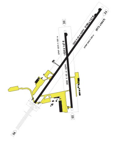 |  |
| ||||
NOTICE: Information listed below may not be current.
| ||||||||||
| ||||||||||
| ||||||||||
| Rotating Beacon: YES | ||||||||||
| ||||||||||
| ||||||||||
| COMMUNICATION INFORMATION APPROACH CONTROL - BELEM APP 119.05 119.5 AUTOMATIC TERMINAL INFORMATION SERVICE - BELEM ATIS 127.6 GROUND CONTROL - GND (Opr 0930-0130Z Mon-Fri.) 121.9 OPERATIONS - BELEM OPS 122.5 TOWER - BELEM TWR 118.7 | ||||||||||
| OPERATING HOURS GROUND CONTROL - Opr 0930-0130Z Mon-Fri. | ||||||||||
| INSTRUMENT APPROACHES VORDME RW06 (DELTA5) ILSDME RW06 (C1) ILSDME RW06 (C2) | ||||||||||
| APPROACH MINIMUMS VORDME RW06 (DELTA5) CIRCL Approach Minimums Category A: 540' MSL and 1600 METERS Category B: 540' MSL and 1600 METERS Category C: 680' MSL and 2800 METERS Category D: 680' MSL and 3200 METERS Category E: 760' MSL and 3600 METERS VORDME RW06 (DELTA5) S-06* Approach Minimums Category A: 540' MSL and 800 METERS Category B: 540' MSL and 800 METERS Category C: 540' MSL and 1200 METERS Category D: 540' MSL and 1600 METERS Category E: 540' MSL and 2000 METERS ILSDME RW06 (C1) CIRCL Approach Minimums Category A: 540' MSL and 1600 METERS Category B: 540' MSL and 1600 METERS Category C: 680' MSL and 2800 METERS Category D: 680' MSL and 3200 METERS Category E: NA ILSDME RW06 (C1) S-ILS Approach Minimums Category A: 248' MSL and 800 METERS Category B: 248' MSL and 800 METERS Category C: 248' MSL and 800 METERS Category D: 248' MSL and 800 METERS Category E: 248' MSL and 800 METERS ILSDME RW06 (C1) S-LOC Approach Minimums Category A: 540' MSL and 800 METERS Category B: 540' MSL and 800 METERS Category C: 540' MSL and 1200 METERS Category D: 540' MSL and 1600 METERS Category E: NA ILSDME RW06 (C2) CIRCL Approach Minimums Category A: 540' MSL and 1600 METERS Category B: 540' MSL and 1600 METERS Category C: 680' MSL and 2800 METERS Category D: 680' MSL and 3200 METERS Category E: 680' MSL and 3600 METERS ILSDME RW06 (C2) S-ILS Approach Minimums Category A: 248' MSL and 800 METERS Category B: 248' MSL and 800 METERS Category C: 248' MSL and 800 METERS Category D: 248' MSL and 800 METERS Category E: 248' MSL and 800 METERS ILSDME RW06 (C2) S-LOC Approach Minimums Category A: 540' MSL and 800 METERS Category B: 540' MSL and 800 METERS Category C: 540' MSL and 1200 METERS Category D: 540' MSL and 1600 METERS Category E: 540' MSL and 2000 METERS | ||||||||||
| APPROACH REMARKS VORDME RW06 (DELTA5) - CIRCLING** - **LANDING RWY 24, CIRCLE NW SECTOR OF AE RODROME. VORDME RW06 (DELTA5) - S-06* - *WHEN ALS INOP, INCREASE VIS 800M. ILSDME RW06 (C1) - CIRCLING*** - ***Landing Rwy 24, circle NW sector of A erodrome. ILSDME RW06 (C1) - S-ILS 06* - *When ALS inop, increase VIS 400M. ILSDME RW06 (C1) - S-LOC 06** - **When ALS inop, increase VIS 800M. ILSDME RW06 (C2) - CIRCLING*** - ***Landing Rwy 24, circle NW sector of A erodrome. ILSDME RW06 (C2) - S-ILS 06* - *When ALS inop, increase VIS 400M. ILSDME RW06 (C2) - S-LOC 06** - **When ALS inop, increase VIS 800M. | ||||||||||
| AIRPORT NAVAIDS BEL - BELEM (VOR-DME) - ON FIELD BEL - BELEM (NDB) - ON FIELD IE - VALDE (NDB) - Bearing: 46° Distance: 1.3 nm | ||||||||||
| TERMINAL AREA REMARKS VORDME RW06 (DELTA5) MISSED APPROACH: Climb to 2000 on R-067. Contact ATC for further instructions. ILSDME RW06 (C1) BEL VOR/DME REQUIRED. CAUTION: GS intercept located 4861 ft inside BEL 7 DME FAF, and 3646 ft inside I BE 8 DME FAF. Glide Slope Angle 3.00 Deg/TCH 60 . MISSED APPROACH: Climb to 2000 on heading 064 . Contact ATC for further instruc tions. ILSDME RW06 (C2) GS intcp pt lctd 4861' inside FAF. Glide Slope Angle 3.00 Deg/TCH 60 . MISSED APPROACH: Climb to 2000 on R- 064. Contact ATC for further instructions. | ||||||||||
Thanks for using FltPlan.com
all rights reserved © 1999-2024 by Flight Plan LLC