TJSJ

LUIS MUNOZ MARIN INTL
SAN JUAN
PR
Time Zone: Atlantic
Lat: N 1826.4
Long: W 06600.1
Elev: 10
Var: +11
Longest Runway: 10400
Clr Del: 126.4
Dept. ATIS: 125.8
Arr. ATIS: 125.8
Ground: 121.9
Tower: 132.05

FBO & Flight Services info for TJSJ

FBOs: Update your Fuel Prices

  click here  
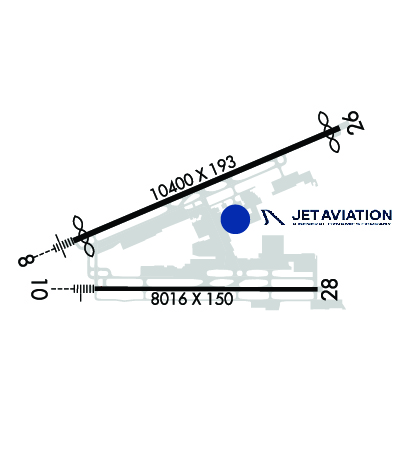
Welcome to Jet Aviation San Juan. We're a full-service FBO with a team of professionals dedicated to providing you with VIP service - whether you're an air charter client, an aircraft owner, or fueling up on your way to destinations in the Caribbean & beyond. We are the only Puerto Rico FBO that offers full-service, on-site U.S. Customs to conveniently expedite processing for passengers and crew.
Ph: 787-791-7005 Fax: 787-791-7095 Freq: 129.17WebsiteE-Mail
                   
Service
Jet
100LL
SAF
MoGas
Fuel Avail: PRIST+$0.10/gal. FOR EMERGENCY AFTER HRS CALL 787-3923-8259
Full7.168.71    Last Update: 04/06/2024 14:50

Self        
Misc. Info: Address: CENTRAL SECTOR, 226 E. RAMP, LUIS MUNOZ INT'L. AIRPORT,   CAROLINA, PR 00983
FltPlan offers handling services for this airport. To get a quote for your next trip:
- Create your flight plan and look for the Handling message link below your international flight plan on the Active Flight Plan List.
- Click on the link and complete the information. We will respond within 48 hours with your personalized quote.
Ph: 786-206-6031
-
-
Website-

AIRPORT AVIATIONPh: 787-791-8500 Fax: 787-791-8505 Freq: 122.95
Service
Jet
100LL
SAF
MoGas
Fuel Avail: Discounts for paying cash. PRIST + $0.20/gal $25 FOR CAN. ,
Full6.267.32    Last Update: 04/06/2024 14:51  
Self        
PIKE AVIATIONPh: 305-447-2676 Fax: 598 26003220
-
ASOSPh: 787-791-6200
-
-
 
CUSTOMSPh: 787-791-0067
-
-
 
If you are an FBO, call 1-203-262-1700 to update your info or email: FltPlan.Advertising@garmin.com
Advertise your FBO on FltPlan.com

Runway & Approach Info for TJSJ
Rwy
Length
Land Dist**
Approach*
  Rwy
Length
Land Dist**
Approach*
08
10400x193  10000'          
ILS
 110.30 - 077°  
  
26
  10400x193  10000'          
 
10
8016x150  8016'          
ILS/DME
 109.70 - 101°  
  
28
  8016x150  8016'          
 
 * only ILS, LOC, LDA, and SDF approaches to a specific runway are shown
** For any Declared Landing Distance Available, please see A/FD or Approach plates
Runway Weight Capability (lbs.) Help
Runway IDSingle WheelDouble WheelDouble Tandem WheelDual Double Wheel
08/26100,000200,000350,000N/A
10/28100,000200,000350,000N/A
These numbers are Advisory and are not limits.   The Airport Manager should have more accurate Weight Limits
Approach Charts
Approaches    
Current Weather/Notams
Customs Information Send updates to Support@FltPlan.com
Phone 787-253-4540
Fax 787-253-7811

Comments 24 HOURS
Database effective 05/16/2024
Airport Diagram of TJSJ
Airport Diagram might not be current.

Facility Name: LUIS MUNOZ MARIN INTL
City Name: SAN JUAN
County: --PUERTO RICO
State abbrev: PR
State Name: PUERTO RICO
   
Ownership: PUBLICLY OWNED
Use: OPEN TO THE PUBLIC
Owner's Name: PUERTO RICO PORTS AUTH
Address: GPO BOX 362829
 SAN JUAN, PR 00936-2829
Owner's Phone: 787-289-7240
  
Manager's Name: MR. JORGE HERNANDEZ
Address: P. O. BOX 38085
 SAN JUAN, PR 00937-1085
Phone: (787) 289-7240
   
FAA Region: SOUTHERN
FAA Field Office: ATL


Sunrise / Sunset times for LUIS MUNOZ MARIN INTL

DateSunriseSunset
04/23/24 Tuesday6:0118:43
04/24/24 Wednesday6:0118:44
04/25/24 Thursday6:0018:44
04/26/24 Friday5:5918:44
04/27/24 Saturday5:5918:45
04/28/24 Sunday5:5818:45
04/29/24 Monday5:5818:45
04/30/24 Tuesday5:5718:46
05/01/24 Wednesday5:5618:46
05/02/24 Thursday5:5618:46
05/03/24 Friday5:5518:47
05/04/24 Saturday5:5518:47
05/05/24 Sunday5:5418:47
05/06/24 Monday5:5418:48

Airport Facilities

Airport Attendance ScheduleCONTINUOUS
Airport Status OPERATIONAL (This Status can change at any time - please check NOTAMS)
Airport Lighting ScheduleSS-SR
Airport Storage AvailableHanger
Extra Services AvailableAir Freight, Cargo Handling, Charter
Wind IndicatorYES - (lighted)
Control TowerYES
CTAF Frequency
Unicom Frequency123.000
Rotating Beacon ColorWG
Segmented CircleNO
Landing FeeYES

Airport Inspection Data

Airport InspectedFEDERAL - performed by FAA AIRPORTS FIELD PERSONNEL
Inspection Date06/11/2020

Airport Services

Type of Fuel AvailableGrade 100, JET AA++
Airframe Repair ServiceMAJOR
Power Plant Repair ServiceMAJOR

Geographic Data

LatitudeN1826.4
LongitudeW06600.1 (ESTIMATED)
Arpt Elevation9ft (SURVEYED)
Magnetic Variation11W
3 miles SEof SAN JUAN
Traffic Pattern Altitude
Sectional ChartPUERTO RICO-VIRGIN ISLANDS

Aircraft Data

Operations (Reported)YearlyAvg. Daily
General Aviation Transient 941626
General Aviation Local 2561
Air Taxi 37475103
Commerical 55292151
Commuter 00
Military 3601
Aircraft based on Field
General Aviation Singles 30
General Aviation Multi 57
Jet Aircraft 6
General Aviation Helicopters 3
Military Aircraft 0
Gliders 0
Ultralights 0

FAA Services

FSS on field NO
FSS tie-in SAN JUAN
FSS Phone 1-800-WX-BRIEF
Who issues Notams TJSJ
Notam D service at airport YES
ARTCC Name SAN JUAN

Federal Status

Airport CertificationAIRPORT RECEIVING SCHEDULED AIR CARRIER SERVICE FROM CARRIERS CERTIFICATED BY THE CIVIL AERONAUTICS BOARD
Aircraft Rescue & Firefighting IndexAIRPORT HAS A CERTIFICATE UNDER CFR PART 139
Airport of EntryNo
Custom Landing RightsYES
Joint Civil/MilitaryNo
Military Landing rightsYES

Federal Agreements

NATIONAL PLAN OF INTEGRATED AIRPORT SYSTEMS (NPIAS)
GRANT AGREEMENTS UNDER FAAP/ADAP/AIP
ASSURANCES PURSUANT TO TITLE VI, CIVIL RIGHTS ACT OF 1964

Remarks

APRON 12 AVBL FOR GA ACFT ONLY.
BASE OPS 1130-2000Z MON-FRI, CLSD WKEND AND HOL.
TWY J BTN J1 AND J5 (NOT INCLUDING J5) CLSD TO ACFT WITH GREATER THAN 118 FT WINGSPAN.
TWY S BTN TWY S2 AND TWY S5 CLSD LGTD AND BARRICADED.
ENGINE RUNUPS PROHIBITED ON GATES AREA.
ACFT 180 TURNS ON TWYS REQUIRES OPS COORDINATIONS.
FBO/GROUND HANDLER MUST SUBMIT 72 HRS PPR FOR ALL MIL ACFT TO: CCO@AEROSTARAIRPORTS.COM OR BY PHONE TO: 787-253-0979
ALL PVT AND CORPORATE AIRCRAFT MUST CONTACT ARPT OPS, BEFORE ARRIVAL, FOR FBOS & GROUND HANDLING INFO AT 787-253-0979.
TWY H BTN TWY C AND TWY H3 CLSD. PLEASE, CONTACT ARPT OPS AT 787-253-0979 FOR FURTHER DETAILS AND RESTRICTIONS.
MILITARY: ANG: INBD ACFT ORIGINATING FR OCONUS WITH A PPR FOR MUNIZ ANGB APN MUST CLEAR CUSTOMS AND BORDER PROTECTION AT CIV SIDE. PRIOR COORD MUST BE MADE WITH ANG AMOPS, FONE 740-9629 AT LEAST ONE BUS DAY PRIOR TO ARRIVAL.
Airport Communications & Frequencies:
ATIS Frequencies:   Hours(local) of Operation: CONTINUOUS
125.8
SAN JUAN Tower Frequencies:   Hours(local) of operation: CONTINUOUS   
132.05
257.8
SAN JUAN Ground Frequencies:
121.9
348.6
Clearance Delivery Frequencies:
126.4
284.6
Pre-Taxi Clearance Frequencies:
126.4
Emergency Frequencies:
121.5
Unicom Frequency:
123.000
SAN JUAN Primary Approach Frequencies:   Hours(local) of operation: CONTINUOUS   
119.4 ;WEST & SW
120.9 ;NORTH & EAST
269.2 ;WEST & SW
290.2 ;NORTH & EAST
SAN JUAN Primary Departure Frequencies:   Hours(local) of operation: CONTINUOUS   
119.4 ;WEST & SW
120.9 ;NORTH & EAST
269.2 ;WEST & SW
290.2 ;NORTH & EAST
Class C Frequencies:
119.4 ;WEST & SW
120.9 ;NORTH & EAST
269.2 ;WEST & SW
290.2 ;NORTH & EAST
Runway Identifications
Runway Identification: 08/26
Length: 10400 ft
Width: 193 ft
Surface: ASPHALT-FAIR CONDITION
Edge lights: High Intensity

Treatment: GROOVED
Weight: PCN 86 /R/C/W/T

 Runway: 08   Runway: 26
Mag heading: 78°Mag heading: 258°
Rwy Slope: -.01% DownRwy Slope: .01% Up
Approach: ILSApproach:
Pattern: Right TrafficPattern: Left Traffic
Markings: PRECISION INSTRUMENTMarkings: PRECISION INSTRUMENT
Marking Condition: GOODMarking Condition: GOOD
Arresting Dev: Arresting Dev:
Lat & Long: N1826.3  W06601.0Lat. & Long.: N1827.0  W06559.3
Elev: 8.2 ft. MSLElev: 6.9 ft. MSL
TCH: 70 ft. AGLTCH:
Visual Glide Path: 3.00 degreesVisual Glide Path:
Displaced Threshold: 400 feetDisplaced Threshold: 400 feet
Touchdown Zone: YESTouchdown Zone: YES
Touchdown Elev.: 9.3 feetTouchdown Elev.: 7.4 feet
Visual Glide Slope: 4-Light PAPI on LEFT side of RunwayVisual Glide Slope:
RVR Equipment: RVR Equipment:
RVV Equipment: NORVV Equipment: NO
Approach Lights: MALSR - 1,400 foot medium intensity approach lighting system with runway alignment indicator lightsApproach Lights:
REIL: NOREIL: YES
Centerline Lights: NOCenterline Lights: NO
Touchdown lights: NOTouchdown lights: NO
Runway Category: Precision Instrument RunwayRunway Category: Runway with a Non-precision Approach having visibility minimums greater than 3/4 mile
Declared Distances: TORA:10400' TODA:10400' ASDA:9784' LDA:9384'Declared Distances: TORA:10400' TODA:10400' ASDA:10308' LDA:9908'
Obstructions: TREEObstructions: TREE
Marked: NOT Marked/LightedMarked: NOT Marked/Lighted
Clearance slope: 42:1Clearance slope: 33:1
Obstruction height: 59 feet AGLObstruction height: 72 feet AGL
Dist. from runway: 2675 feetDist. from runway: 2600 feet
Centerline offset: 300 right of centerlineCenterline offset: 800 feet right of centerline
Comments: Comments:
Runway Identification: 10/28
Length: 8016 ft
Width: 150 ft
Surface: CONCRETE-GOOD CONDITION
Edge lights: High Intensity

Treatment: GROOVED
Weight: PCN 68 /R/C/W/T

 Runway: 10   Runway: 28
Mag heading: 101°Mag heading: 281°
Rwy Slope: .00% UpRwy Slope: .00% Down
Approach: ILS/DMEApproach:
Pattern: Right TrafficPattern: Left Traffic
Markings: PRECISION INSTRUMENTMarkings: PRECISION INSTRUMENT
Marking Condition: GOODMarking Condition: GOOD
Arresting Dev: Arresting Dev:
Lat & Long: N1826.0  W06600.8Lat. & Long.: N1826.0  W06559.4
Elev: 9.3 ft. MSLElev: 9.5 ft. MSL
TCH: 53 ft. AGLTCH: 53 ft. AGL
Visual Glide Path: 3.00 degreesVisual Glide Path: 3.00 degrees
Displaced Threshold: NoDisplaced Threshold: No
Touchdown Zone: YESTouchdown Zone: YES
Touchdown Elev.: 9.3 feetTouchdown Elev.: 9.6 feet
Visual Glide Slope: 4-Light PAPI on LEFT side of RunwayVisual Glide Slope: 4-Light PAPI on LEFT side of Runway
RVR Equipment: RVR Equipment:
RVV Equipment: NORVV Equipment: NO
Approach Lights: MALSR - 1,400 foot medium intensity approach lighting system with runway alignment indicator lightsApproach Lights:
REIL: NOREIL: NO
Centerline Lights: NOCenterline Lights: NO
Touchdown lights: NOTouchdown lights: NO
Runway Category: Precision Instrument RunwayRunway Category: Runway with a Visual Approach
Declared Distances: TORA:8016' TODA:8016' ASDA:8016' LDA:8016'Declared Distances: TORA:8016' TODA:8016' ASDA:8016' LDA:8016'
Obstructions: TREEObstructions: TREES
Marked: NOT Marked/LightedMarked: NOT Marked/Lighted
Clearance slope: 40:1Clearance slope: 33:1
Obstruction height: 50 feet AGLObstruction height: 24 feet AGL
Dist. from runway: 2200 feetDist. from runway: 1000 feet
Centerline offset: 300 left of centerlineCenterline offset: B
Comments: Comments:
C:243/P: