Click here for more info on on SMS!

TJPS

MERCEDITA PUERTO RICO
PONCE
PR
Time Zone: Atlantic
Lat: N 1800.5
Long: W 06633.9
Elev: 28
Var: +11
Longest Runway: 8004
Clr Del: 121.9
CTAF: 122.7

FBO & Flight Services info for TJPS

FBOs: Update your Fuel Prices

AERO SERVICESPh: 787-844-5223
-
Freq: 122.7
Service
Jet
100LL
SAF
MoGas
Fuel Avail: ~~Availability of Services Is Unknown
Full        Last Update: 04/25/2024 05:27:33

Self        
 Address: MERCEDITA ARPT BOX 323   MERCEDITA, PR 00715
If you are an FBO, call 1-203-262-1700 to update your info or email: FltPlan.Advertising@garmin.com
Advertise your FBO on FltPlan.com

Runway & Approach Info for TJPS
Rwy
Length
Land Dist**
Approach*
  Rwy
Length
Land Dist**
Approach*
12
8004x150  6122'          
 
  
30
  8004x150  7756'          
 
 * only ILS, LOC, LDA, and SDF approaches to a specific runway are shown
** For any Declared Landing Distance Available, please see A/FD or Approach plates
Runway Weight Capability (lbs.) Help
Runway IDSingle WheelDouble WheelDouble Tandem WheelDual Double Wheel
12/30N/AN/AN/AN/A
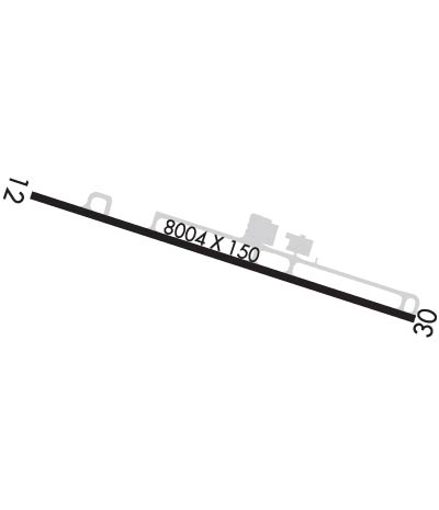
These numbers are Advisory and are not limits.   The Airport Manager should have more accurate Weight Limits
Approach Charts
Approaches    
Current Weather/Notams
Customs Information Send updates to Support@FltPlan.com
Phone 787-841-3104
Fax N/A

Comments Mon-Sat 0800-1700 *1 hr advance notice required *Maximum passengers per flight: 8 *Prior arrangements need to be made *Unstaffed – landing rights airport
Database effective 05/16/2024
Airport Diagram of TJPS
Airport Diagram might not be current.

Facility Name: MERCEDITA
City Name: PONCE
County: --PUERTO RICO
State abbrev: PR
State Name: PUERTO RICO
   
Ownership: PUBLICLY OWNED
Use: OPEN TO THE PUBLIC
Owner's Name: PUERTO RICO PORT AUTH
Address: PO BOX 2829
 SAN JUAN, PR 00936
Owner's Phone: 787-729-8715
  
Manager's Name: JOSE RIOLLANO
Address: P.O. BOX 670
 MERCEDITA, PR 00715
Phone: 787-729-8715; EXT 2401
   
FAA Region: SOUTHERN
FAA Field Office: ATL


Sunrise / Sunset times for MERCEDITA

DateSunriseSunset
04/24/24 Wednesday6:0318:46
04/25/24 Thursday6:0318:46
04/26/24 Friday6:0218:46
04/27/24 Saturday6:0118:46
04/28/24 Sunday6:0118:47
04/29/24 Monday6:0018:47
04/30/24 Tuesday6:0018:47
05/01/24 Wednesday5:5918:48
05/02/24 Thursday5:5918:48
05/03/24 Friday5:5818:48
05/04/24 Saturday5:5818:49
05/05/24 Sunday5:5718:49
05/06/24 Monday5:5718:49
05/07/24 Tuesday5:5618:50

Airport Facilities

Airport Attendance ScheduleCONTINUOUS
Airport Status OPERATIONAL (This Status can change at any time - please check NOTAMS)
Airport Lighting ScheduleHIRL RY 12/30 PRESET MED INTST DUSK-2200; TO INCR INTST & ACTVT HIRL RY 12/30 AND REIL RY 12 AFTER 2200 - CTAF. PAPI RY 30 OPER CONT.
Airport Storage AvailableTie Downs, Hanger
Extra Services AvailableCrop Dusting, Cargo Handling, Charter, Glider, Flight Instruction, Aircraft Rental, Glider Towing
Wind IndicatorYES - (lighted)
Control TowerNO
CTAF Frequency122.700
Unicom Frequency122.700
Rotating Beacon ColorWG
Segmented CircleYES
Landing FeeYES; FEE FOR OTHER THAN HOME BASED ACFT.

Airport Inspection Data

Airport InspectedFEDERAL - performed by FAA AIRPORTS FIELD PERSONNEL
Inspection Date02/23/2021

Airport Services

Type of Fuel AvailableJET A (freeze point -40C)
Airframe Repair ServiceMINOR
Power Plant Repair ServiceMINOR

Geographic Data

LatitudeN1800.5
LongitudeW06633.9 (ESTIMATED)
Arpt Elevation28ft (SURVEYED)
Magnetic Variation11W
3 miles Eof PONCE
Traffic Pattern Altitude
Sectional ChartPUERTO RICO-VIRGIN ISLANDS

Aircraft Data

Operations (Reported)YearlyAvg. Daily
General Aviation Transient 00
General Aviation Local 22226
Air Taxi 00
Commerical 17735
Commuter 00
Military 1120
Aircraft based on Field
General Aviation Singles 12
General Aviation Multi 4
Jet Aircraft 0
General Aviation Helicopters 3
Military Aircraft 0
Gliders 0
Ultralights 0

FAA Services

FSS on field NO
FSS tie-in SAN JUAN
FSS Phone 1-800-WX-BRIEF
Who issues Notams TJPS
Notam D service at airport YES
ARTCC Name SAN JUAN

Federal Status

Airport CertificationAIRPORT RECEIVING SCHEDULED AIR CARRIER SERVICE FROM CARRIERS CERTIFICATED BY THE CIVIL AERONAUTICS BOARD; PPR 24 HRS FOR INDEX C & ABOVE UNSKED ACR OPNS WITH MORE THAN 30 PSGR SEATS CALL AMGR 787-842-6292.
Aircraft Rescue & Firefighting IndexAIRPORT HAS A CERTIFICATE UNDER CFR PART 139
Airport of EntryNo
Custom Landing RightsYES
Joint Civil/MilitaryNo
Military Landing rightsYES

Federal Agreements

NATIONAL PLAN OF INTEGRATED AIRPORT SYSTEMS (NPIAS)
GRANT AGREEMENTS UNDER FAAP/ADAP/AIP
ASSURANCES PURSUANT TO TITLE VI, CIVIL RIGHTS ACT OF 1964

Remarks

CUSTOMS AVAILABLE 1200Z TO 2100Z MON-FRI.
FOR CD IF FREQ ARE OTS CTC SAN JUAN CERAP AT 787-253-8664/8666
Airport Communications & Frequencies:
CTAF Frequency:
122.700
Unicom Frequency:
122.700
Remarks
  • APCH/DEP SVC PRVDD BY SAN JUAN CERAP ON FREQS 118.75/269.0 (EL YUNQUE RCAG).
  • CLNC DEL PRVDD BY SAN JUAN CERAP ON FREQ 121.9.
  • ATCT CLSD INDEFLY.
  • Runway Identifications
    Runway Identification: 12/30
    Length: 8004 ft
    Width: 150 ft
    Surface: ASPHALT-GOOD CONDITION
    Edge lights: High Intensity

    Treatment: GROOVED
    Weight: PCN 42 /F/B/X/T

     Runway: 12   Runway: 30
    Mag heading: 119°Mag heading: 299°
    Rwy Slope: -.01% DownRwy Slope: .01% Up
    Approach: Approach:
    Pattern: Right TrafficPattern: Left Traffic
    Markings: NONPRECISION INSTRUMENTMarkings: NONPRECISION INSTRUMENT
    Marking Condition: GOODMarking Condition: GOOD
    Arresting Dev: Arresting Dev:
    Lat & Long: N1800.7  W06634.5Lat. & Long.: N1800.3  W06633.2
    Elev: 28.4 ft. MSLElev: 27.2 ft. MSL
    TCH: TCH: 53 ft. AGL
    Visual Glide Path: Visual Glide Path: 3.00 degrees
    Displaced Threshold: 1882 feetDisplaced Threshold: 248 feet
    Touchdown Zone: YESTouchdown Zone: YES
    Touchdown Elev.: 27.3 feetTouchdown Elev.: 25.1 feet
    Visual Glide Slope: Visual Glide Slope: 4-Light PAPI on RIGHT side of Runway
    RVR Equipment: RVR Equipment:
    RVV Equipment: NORVV Equipment: NO
    Approach Lights: Approach Lights:
    REIL: YESREIL: YES
    Centerline Lights: NOCenterline Lights: NO
    Touchdown lights: NOTouchdown lights: NO
    Runway Category: Runway with a Non-precision Approach having visibility minimums greater than 3/4 mileRunway Category: Runway with a Non-precision Approach having visibility minimums greater than 3/4 mile
    Declared Distances: TORA:8004' TODA:8004' ASDA:7357' LDA:5488'Declared Distances: TORA:8004' TODA:8004' ASDA:7004' LDA:6757'
    Obstructions: PLINEObstructions: TREES
    Marked: LIGHTEDMarked: NOT Marked/Lighted
    Clearance slope: 13:1; APCH RATIO 16:1 TO DSPLCD THR.Clearance slope: 33:1
    Obstruction height: 295 feet AGLObstruction height: 41 feet AGL
    Dist. from runway: 4155 feetDist. from runway: 1570 feet
    Centerline offset: 800 left of centerlineCenterline offset: 75 feet left of centerline
    Comments: Comments:
    C:3/P: