Current Weather/Notams (Metars, TAFs, Notams, NWS Forecast, PIREPS, and nearby weather)
Customs Information Send updates to Support@FltPlan.com
Customs Not Available
Database effective 04/18/2024
Airport Diagram might not be current.
|
| Facility Name: | EUGENIO MARIA DE HOSTOS |
| City Name: | MAYAGUEZ |
| County: | --PUERTO RICO |
| State abbrev: | PR |
| State Name: | PUERTO RICO |
| | |
| Ownership: | PUBLICLY OWNED |
| Use: | OPEN TO THE PUBLIC |
| Owner's Name: | PUERTO RICO PORTS AUTH |
| Address: | P.O. BOX 362829 |
| | SAN JUAN, PR 00932-2829 |
| Owner's Phone: | 787-729-8715 |
| | |
| Manager's Name: | WILLIAM FEBLES |
| Address: | BOX 710 |
| | MAYAGUEZ, PR 00681-0710 |
| Phone: | 787-833-0148 |
| | |
| FAA Region: | SOUTHERN |
| FAA Field Office: | ATL |
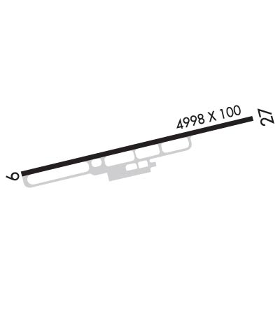
Runway Identifications
Runway Identification: 09/27Length: 4999 ft
Width: 75 ft
Surface: ASPHALT-GOOD CONDITION
Edge lights: Medium IntensityTreatment: NONE
| | Runway: 09 | | Runway: 27 |
| Mag heading: | 86° | Mag heading: | 266° |
| Rwy Slope: | .17% Up | Rwy Slope: | -.17% Down |
| Approach: | | Approach: | |
| Pattern: | Left Traffic | Pattern: | Left Traffic |
| Markings: | NONPRECISION INSTRUMENT | Markings: | NONPRECISION INSTRUMENT |
| Marking Condition: | GOOD | Marking Condition: | GOOD |
| Arresting Dev: | | Arresting Dev: | |
| Lat & Long: | N1815.2 W06709.3 | Lat. & Long.: | N1815.4 W06708.5 |
| Elev: | 16.2 ft. MSL | Elev: | 24.6 ft. MSL |
| TCH: | 40 ft. AGL | TCH: | 51 ft. AGL |
| Visual Glide Path: | 3.00 degrees | Visual Glide Path: | 3.50 degrees |
| Displaced Threshold: | 300 feet | Displaced Threshold: | No |
| Touchdown Zone: | YES | Touchdown Zone: | YES |
| Touchdown Elev.: | 28.6 feet | Touchdown Elev.: | 28.6 feet |
| Visual Glide Slope: | 4-Light PAPI on LEFT side of Runway | Visual Glide Slope: | 4-Light PAPI on LEFT side of Runway |
| RVR Equipment: | | RVR Equipment: | |
| RVV Equipment: | NO | RVV Equipment: | NO |
| Approach Lights: | | Approach Lights: | |
| REIL: | YES | REIL: | NO |
| Centerline Lights: | NO | Centerline Lights: | NO |
| Touchdown lights: | NO | Touchdown lights: | NO |
| Runway Category: | Runway with a Non-precision Approach having visibility minimums greater than 3/4 mile | Runway Category: | Runway with a Visual Approach |
| Declared Distances: | | Declared Distances: | |
| Obstructions: | TREE; 47 FT LIGHTED/MARKED POWER LINES, 1800 FT DSTC, 0 FT B, 34:1. | Obstructions: | TREES |
| Marked: | NOT Marked/Lighted | Marked: | NOT Marked/Lighted |
| Clearance slope: | 8:1; 30 FT TREE, 200 FT DSTC AT BEGINNING OF THE APCH SFC, 190 FT L, OBSTN CLNC 0:1. | Clearance slope: | 1:1 |
| Obstruction height: | 16 feet AGL | Obstruction height: | 30 feet AGL |
| Dist. from runway: | 338 feet | Dist. from runway: | 200 feet |
| Centerline offset: | 127 left of centerline | Centerline offset: | 190 feet left of centerline |
| Comments: | | Comments: | 20' TREES, 57 FT DSTC, 140 FT L. |
