Click here for more info on on SMS!

PHTO

HILO INTL
HILO
HI
Time Zone: Hawaii
Lat: N 1943.2
Long: W 15502.9
Elev: 38
Var: -11
Longest Runway: 9800
Dept. ATIS: 126.4
Arr. ATIS: 126.4
Ground: 121.9
Tower: 118.1

FBO & Flight Services info for PHTO

FBOs: Update your Fuel Prices
Atlantic Aviation is your premier aviation service provider with more than 100 locations in North America, including Hawaii and the Caribbean. We provide standard ground services you'd expect, with a detailed focus on ensuring an unforgettable customer experience.
Ph: 808-961-6601 Fax: 808-935-6934 Freq: 128.95Website-
Service
Jet
100LL
SAF
MoGas
Fuel Avail: Call Out Fee after 17:00 - 24/7
Full8.429.94    Last Update: 04/19/2024 13:29:54

Self        
Misc. Info: Address: GATE 27,   HILO, HI 96720

SIGNATUREPh: 808-934-7757
-
Freq: 130.8
Service
Jet
100LL
SAF
MoGas
Fuel Avail: ONLY JET A FUEL AVAILABLE. Jet A w/Prist, add $0.10 per gallon.
Full8.42      Last Update: 04/19/2024 07:53  
Self        
 Address: 2450 KEKUANAOA ST. 206,   HILO, HI 96720
ASOSPh: 808-961-2077
-
-
 
If you are an FBO, call 1-203-262-1700 to update your info or email: FltPlan.Advertising@garmin.com
Advertise your FBO on FltPlan.com

Runway & Approach Info for PHTO
Rwy
Length
Land Dist**
Approach*
  Rwy
Length
Land Dist**
Approach*
03
5600x150  5251'          
 
  
21
  5600x150  5600'          
 
08
9800x150  9800'          
 
  
26
  9800x150  9800'          
ILS/DME
 110.70 - 259°  
 * only ILS, LOC, LDA, and SDF approaches to a specific runway are shown
** For any Declared Landing Distance Available, please see A/FD or Approach plates
Runway Weight Capability (lbs.) Help
Runway IDSingle WheelDouble WheelDouble Tandem WheelDual Double Wheel
03/2175,00080,000140,000410,000
08/2675,000250,000350,000850,000
These numbers are Advisory and are not limits.   The Airport Manager should have more accurate Weight Limits
Approach Charts
Approaches    
Current Weather/Notams
Customs Information Send updates to Support@FltPlan.com
Phone 808-933-6975
Fax 808-933-6976

Comments Mon-Fri 0600-1400 *24 hrs advance notice required *Call prior to 1600 on preceding weekday.
Database effective 04/18/2024
Airport Diagram of PHTO
Airport Diagram might not be current.

Facility Name: HILO INTL
City Name: HILO
County: HAWAII
State abbrev: HI
State Name: HAWAII
   
Ownership: PUBLICLY OWNED
Use: OPEN TO THE PUBLIC
Owner's Name: STATE OF HAWAII ARPT DIV DOT
Address: HONOLULU INTL ARPT
 HONOLULU, HI 96819
Owner's Phone: 808-838-8600
  
Manager's Name: TIFFINIE C SMITH; HAWAII DIST MGR CHAUNCEY WONG YUEN AT KEAHOLE ARPT 808-327-9520 EXT 222.
Address: HAWAII AIRPORTS DISTRICT MANAGER, 2450 KEKUANAOA STREET #215
 HILO, HI 96720
Phone: 808-961-9300
   
FAA Region: WESTERN-PACIFIC
FAA Field Office: HNL


Sunrise / Sunset times for HILO INTL

DateSunriseSunset
04/19/24 Friday5:5918:40
04/20/24 Saturday5:5818:40
04/21/24 Sunday5:5718:40
04/22/24 Monday5:5718:41
04/23/24 Tuesday5:5618:41
04/24/24 Wednesday5:5518:41
04/25/24 Thursday5:5518:42
04/26/24 Friday5:5418:42
04/27/24 Saturday5:5318:42
04/28/24 Sunday5:5318:43
04/29/24 Monday5:5218:43
04/30/24 Tuesday5:5118:43
05/01/24 Wednesday5:5118:44
05/02/24 Thursday5:5018:44

Airport Facilities

Airport Attendance Schedule7 Days A Week 0700-2030
Airport Status OPERATIONAL (This Status can change at any time - please check NOTAMS)
Airport Lighting ScheduleDUSK-DAWN. ACTVT MIRL RY 03/21 & HIRL RY 08/26; MALSR RY 26 & ODALS RY 08 - 118.1.
Airport Storage AvailableTie Downs
Extra Services AvailableAir Freight, Crop Dusting, Cargo Handling, Charter, Flight Instruction, Aircraft Rental
Wind IndicatorYES - (lighted)
Control TowerYES
CTAF Frequency118.100
Unicom Frequency
Rotating Beacon ColorWG
Segmented CircleYES
Landing FeeNO

Airport Inspection Data

Airport InspectedFEDERAL - performed by FAA AIRPORTS FIELD PERSONNEL
Inspection Date01/26/2024

Airport Services

Type of Fuel AvailableGrade 100LL, JET A (freeze point -40C); -10FOR FUEL ADVANCE NOTICE REQUIRED, FOR 100LL CALL (808) 960-5146 OR CTC FREQ 128.95, FOR JET-A CALL (808) 934-7757 OR CTC FREQ 130.8.
Airframe Repair ServiceMINOR
Power Plant Repair ServiceNONE

Geographic Data

LatitudeN1943.2
LongitudeW15502.9 (ESTIMATED)
Arpt Elevation37ft (SURVEYED)
Magnetic Variation11E
2 miles Eof HILO
Traffic Pattern Altitude
Sectional ChartHAWAIIAN ISLANDS

Aircraft Data

Operations (Reported)YearlyAvg. Daily
General Aviation Transient 32689
General Aviation Local 762621
Air Taxi 1423639
Commerical 1705047
Commuter 00
Military 33939
Aircraft based on Field
General Aviation Singles 10
General Aviation Multi 3
Jet Aircraft 0
General Aviation Helicopters 12
Military Aircraft 9
Gliders 1
Ultralights 0

FAA Services

FSS on field NO
FSS tie-in HONOLULU
FSS Phone 1-800-WX-BRIEF
Who issues Notams ITO
Notam D service at airport YES
ARTCC Name HONOLULU CONTROL FACILITY

Federal Status

Airport CertificationAIRPORT RECEIVING SCHEDULED AIR CARRIER SERVICE FROM CARRIERS CERTIFICATED BY THE CIVIL AERONAUTICS BOARD; ARFF AVBL 24 HRS, CONTACT 118.1 OR 808-961-9317.
Aircraft Rescue & Firefighting IndexAIRPORT HAS A CERTIFICATE UNDER CFR PART 139
Airport of EntryNo
Custom Landing RightsYES
Joint Civil/MilitaryNo
Military Landing rightsYES

Federal Agreements

NATIONAL PLAN OF INTEGRATED AIRPORT SYSTEMS (NPIAS)
GRANT AGREEMENTS UNDER FAAP/ADAP/AIP
ASSURANCES PURSUANT TO TITLE VI, CIVIL RIGHTS ACT OF 1964
AGREEMENT UNDER DLAND OR DCLA HAS EXPIRED.

Remarks

THIS AIRPORT HAS BEEN SURVEYED BY THE NATIONAL GEODETIC SURVEY.
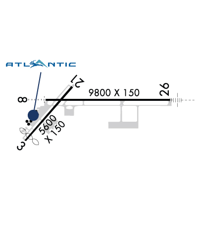
RWY 08 PVD 1325' MKD BY CHEVRONS, UNUSBL FOR LNDG/TKOF/OVRN/STY; CANNOT BE USED IN COMPUTING TKOF DATA.
DIVISION 1.1, 1.2, 1.3 EXPLOSIVES PROHIBITED.
PPR FROM AIRPORT MANAGER FOR TRANSPORTATION OF DIVISION 1.4 EXPLOSIVES AND HAZARDOUS MATERIAL IN OR OUT OF AIRPORT.
NOISE ABATEMENT: AVOID OVERFLIGHT OF NOISE SENSITIVE RESIDENTIAL AREAS N, W AND SW OF AIRPORT.
RY 3/21 CLSD TO TURBINE ACFT 1800-0600.
RY 08/26 SINGLE-BELLY TWIN TANDEM (SBTT) GWT 450,000 LBS.
RY 03/21 SINGLE-BELLY TWIN TANDEM (SBTT) GWT 230,000 LBS.
FOR CD WHEN ATCT IS CLSD CTC HONOLULU CONTROL FACILITY AT 808-840-6262.
TWY E BTN TWY A AND RWY 08/26 PONDING DRG HVY RAINS.
RWYS 8, 21 AND 26 WIND CONES ARE LCTD IN THE ROFA.
ATCT CTLS ENTRY/EXIT TFC ON TWYS F&E TO EAST TRML RAMP.
181' LGTD SMOKE STACK 1/2 SM SOUTH OF FLD.
PPR FROM ARPT MGR FOR TRANSIENT PARKING.
BE ALERT OCNL BIRD FLOCKS ON ARPT AND IN FLT ACROSS RWY 08/26 AND 03/21.
(A70A) JET FUEL AVBL MON-SAT 0800-1700 CALL (808) 935-6881/6122 OR 961-6601.
(E93) NO MKD PAD, HEL OPER FM FBO HANGER AREA.
RWY 03/2 1 RY 03/21 NO JET OPNS BTN 1800-0600.
Airport Communications & Frequencies:
ATIS Frequencies:   Hours(local) of Operation: CONTINUOUS
126.4
HILO Tower Frequencies:   Hours(local) of operation: 0600-2200   
118.1
263.1
HILO Ground Frequencies:
121.9
Emergency Frequencies:
121.5
243.0
CTAF Frequency:
118.100
Remarks
  • APCH/DEP SVC PRVDD BY HONOLULU CONTROL FACILITY (ZHN) ON FREQ. 126.6/284.6 (HAMAKUA RCAG) WHEN HILO TRACON (ITO) CLSD.
  • WHEN ATCT CLSD TRANSMIT INTENTIONS ON FREQ 118.1.
  • PILOTS SHUD WATCH FOR SIGNAL LIGHT-GUN OPERATIONS FROM TOWER ON WEST SIDE OF ARPT; NEW TOWER NEAR EAST TERMINAL RAMP UNDER CONSTRUCTION.
  • HILO Primary Approach Frequencies:   Hours(local) of operation: 0600-2200   
    119.7
    269.2
    HCF CENTER Part-time Approach Frequencies:   Hours(local) of operation: 2200-0600   
    120.25
    323.0
    HILO Primary Departure Frequencies:   Hours(local) of operation: 0600-2200   
    119.7
    269.2
    HCF CENTER Part-time Departure Frequencies:   Hours(local) of operation: 2200-0600   
    120.25
    323.0
    Runway Identifications
    Runway Identification: 03/21
    Length: 5600 ft
    Width: 150 ft
    Surface: ASPHALT-FAIR CONDITION
    Edge lights: Medium Intensity

    Treatment: GROOVED
    Weight: PCN 69 /F/B/W/T

     Runway: 03   Runway: 21
    Mag heading: 30°Mag heading: 210°
    Rwy Slope: -.14% DownRwy Slope: .14% Up
    Approach: Approach:
    Pattern: Left TrafficPattern: Left Traffic
    Markings: NONPRECISION INSTRUMENTMarkings: NONPRECISION INSTRUMENT
    Marking Condition: FAIRMarking Condition: FAIR
    Arresting Dev: Arresting Dev:
    Lat & Long: N1942.7  W15503.7Lat. & Long.: N1943.4  W15503.1
    Elev: 33.3 ft. MSLElev: 25.4 ft. MSL
    TCH: 48 ft. AGLTCH:
    Visual Glide Path: 3.25 degreesVisual Glide Path:
    Displaced Threshold: 349 feetDisplaced Threshold: No
    Touchdown Zone: YESTouchdown Zone: YES
    Touchdown Elev.: 33.7 feetTouchdown Elev.: 31.4 feet
    Visual Glide Slope: 4-BOX VASI ON LEFT SIDE OF RUNWAYVisual Glide Slope:
    RVR Equipment: RVR Equipment:
    RVV Equipment: NORVV Equipment: NO
    Approach Lights: Approach Lights:
    REIL: YESREIL: NO
    Centerline Lights: NOCenterline Lights: NO
    Touchdown lights: NOTouchdown lights: NO
    Runway Category: Runway with a Visual ApproachRunway Category: Runway with a Non-precision Approach having visibility minimums greater than 3/4 mile
    Declared Distances: TORA:5600' TODA:5600' ASDA:5600' LDA:5251'Declared Distances: TORA:5251' TODA:5251' ASDA:5510' LDA:5510'
    Obstructions: FENCEObstructions: POLE
    Marked: NOT Marked/LightedMarked: NOT Marked/Lighted
    Clearance slope: APCH RATIO 20:1 FM DSPLCD THR.Clearance slope: 28:1
    Obstruction height: 7 feet AGLObstruction height: 37 feet AGL
    Dist. from runway: 200 feetDist. from runway: 1050 feet
    Centerline offset: Centerline offset: 20 feet left of centerline
    Comments: Comments:
    Runway Identification: 08/26
    Length: 9800 ft
    Width: 150 ft
    Surface: ASPHALT-GOOD CONDITION
    Edge lights: High Intensity

    Treatment: GROOVED
    Weight: PCN 69 /F/B/W/T

     Runway: 08   Runway: 26
    Mag heading: 79°Mag heading: 259°
    Rwy Slope: .10% UpRwy Slope: -.10% Down
    Approach: Approach: ILS/DME
    Pattern: Left TrafficPattern: Left Traffic
    Markings: PRECISION INSTRUMENTMarkings: PRECISION INSTRUMENT
    Marking Condition: GOODMarking Condition: GOOD
    Arresting Dev: Arresting Dev:
    Lat & Long: N1943.3  W15503.5Lat. & Long.: N1943.3  W15501.8
    Elev: 27.3 ft. MSLElev: 37.0 ft. MSL
    TCH: 71 ft. AGLTCH: 70 ft. AGL
    Visual Glide Path: 3.00 degreesVisual Glide Path: 2.60 degrees
    Displaced Threshold: NoDisplaced Threshold: No
    Touchdown Zone: YESTouchdown Zone: YES
    Touchdown Elev.: 30.1 feetTouchdown Elev.: 37.6 feet
    Visual Glide Slope: 4-Light PAPI on RIGHT side of Runway; PAPI RWY 08 UNUSBL BYD 3.0 NMVisual Glide Slope: 4-Light PAPI on LEFT side of Runway
    RVR Equipment: RVR Equipment:
    RVV Equipment: NORVV Equipment: NO
    Approach Lights: ODALS - omnidirectional approach lighting systemApproach Lights: MALSR - 1,400 foot medium intensity approach lighting system with runway alignment indicator lights
    REIL: NOREIL: NO
    Centerline Lights: NOCenterline Lights: NO
    Touchdown lights: NOTouchdown lights: NO
    Runway Category: Runway with a Visual ApproachRunway Category: Precision Instrument Runway
    Declared Distances: TORA:9800' TODA:9800' ASDA:9800' LDA:9800'Declared Distances: TORA:9800' TODA:9800' ASDA:9800' LDA:9800'
    Obstructions: TREEObstructions: TREE
    Marked: NOT Marked/LightedMarked: NOT Marked/Lighted
    Clearance slope: 43:1Clearance slope: 26:1
    Obstruction height: 32 feet AGLObstruction height: 25 feet AGL
    Dist. from runway: 1400 feetDist. from runway: 650 feet
    Centerline offset: 600 right of centerlineCenterline offset: 400 feet left of centerline
    Comments: +6' FENCES 400' LEFT OF CNTRLN.Comments:
    C:9/P: