
| |||||
|
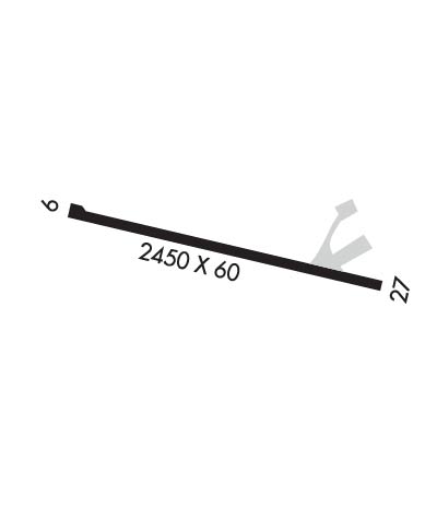
| Rwy | Rwy | |||||||
| 2450x60 | 2261' | 2450x60 | 2450' | |||||
| Runway ID | Single Wheel | Double Wheel | Double Tandem Wheel | Dual Double Wheel |
| 09/27 | 18,000 | N/A | N/A | N/A |
| These numbers are Advisory and are not limits. The Airport Manager should have more accurate Weight Limits | ||||
| FltPlan does not have IFR approach charts available for PHPA. |
 Airport Diagram might not be current. | |
| Facility Name: | PORT ALLEN |
| City Name: | HANAPEPE |
| County: | KAUAI |
| State abbrev: | HI |
| State Name: | HAWAII |
| Ownership: | PUBLICLY OWNED |
| Use: | OPEN TO THE PUBLIC |
| Owner's Name: | HAWAII ST ARPTS DIV |
| Address: | 400 RODGERS BLVD, SUITE 700 |
| HONOLULU, HI 96819 | |
| Owner's Phone: | 808-838-8701 |
| Manager's Name: | CRAIG DAVIS; KAUAI AIRPORT DISTRICT MANAGER |
| Address: | LIHUE ARPT |
| LIHUE, HI 96766 | |
| Phone: | 808-274-3800 |
| FAA Region: | WESTERN-PACIFIC |
| FAA Field Office: | HNL |
| Date | Sunrise | Sunset |
|---|---|---|
| 04/25/24 Thursday | 6:10 | 19:02 |
| 04/26/24 Friday | 6:10 | 19:03 |
| 04/27/24 Saturday | 6:09 | 19:03 |
| 04/28/24 Sunday | 6:08 | 19:04 |
| 04/29/24 Monday | 6:08 | 19:04 |
| 04/30/24 Tuesday | 6:07 | 19:04 |
| 05/01/24 Wednesday | 6:06 | 19:05 |
| 05/02/24 Thursday | 6:06 | 19:05 |
| 05/03/24 Friday | 6:05 | 19:06 |
| 05/04/24 Saturday | 6:04 | 19:06 |
| 05/05/24 Sunday | 6:04 | 19:07 |
| 05/06/24 Monday | 6:03 | 19:07 |
| 05/07/24 Tuesday | 6:03 | 19:07 |
| 05/08/24 Wednesday | 6:02 | 19:08 |
| Airport Attendance Schedule | UNATTENDED |
| Airport Status | OPERATIONAL (This Status can change at any time - please check NOTAMS) |
| Airport Lighting Schedule | |
| Airport Storage Available | Tie Downs, Hanger |
| Extra Services Available | Parachute Jumping |
| Wind Indicator | YES - (unlit) |
| Control Tower | NO |
| CTAF Frequency | 122.900 |
| Unicom Frequency | |
| Rotating Beacon Color | |
| Segmented Circle | YES |
| Landing Fee | NO |
| Airport Inspected | STATE - performed by PRIVATE CONTRACT PERSONNEL |
| Inspection Date | 01/14/2022 |
| Type of Fuel Available | None |
| Airframe Repair Service | None |
| Power Plant Repair Service | None |
| Latitude | N2153.8 |
| Longitude | W15936.2 (ESTIMATED) |
| Arpt Elevation | 24ft (SURVEYED) |
| Magnetic Variation | 11E |
| 1 miles SW | of HANAPEPE |
| Traffic Pattern Altitude | 800 |
| Sectional Chart | HAWAIIAN ISLANDS |
| Operations (Reported) | Yearly | Avg. Daily |
|---|---|---|
| General Aviation Transient | 500 | 1 |
| General Aviation Local | 1400 | 4 |
| Air Taxi | 1716 | 5 |
| Commerical | 0 | 0 |
| Commuter | 0 | 0 |
| Military | 50 | 0 |
| Aircraft based on Field | |
|---|---|
| General Aviation Singles | 0 |
| General Aviation Multi | 0 |
| Jet Aircraft | 0 |
| General Aviation Helicopters | 1 |
| Military Aircraft | 0 |
| Gliders | 0 |
| Ultralights | 0 |
| FSS on field | NO |
| FSS tie-in | HONOLULU; FOR AVN INFO 2200-0600 CTC HONOLULU FSS ON 122.6. |
| FSS Phone | 1-800-WX-BRIEF |
| Who issues Notams | LIH |
| Notam D service at airport | YES |
| ARTCC Name | HONOLULU CONTROL FACILITY |
| Airport Certification | |
| Aircraft Rescue & Firefighting Index | None |
| Airport of Entry | No |
| Custom Landing Rights | No |
| Joint Civil/Military | No |
| Military Landing rights | YES |
| NATIONAL PLAN OF INTEGRATED AIRPORT SYSTEMS (NPIAS) |
| GRANT AGREEMENTS UNDER FAAP/ADAP/AIP |
| ASSURANCES PURSUANT TO TITLE VI, CIVIL RIGHTS ACT OF 1964 |
| NOISE ABATEMENT: AVOID OVERFLIGHT OF THE SALT POND, STATE RECREATIONAL BEACH PARK. RESIDENTIAL AND COMMERCIAL AREAS NORTH OF AIRFIELD. |
| SKYDIVING ON AND INVOF ARPT. |
| DAILY HELICOPTER ACTIVITY ON AND INVOF ARPT. |
| NO AIRFIELD SECURITY, OVERNIGHT AIRCRAFT PARKING NOT AUTHORIZED |
| FOR CD CTC HONOLULU CONTROL FACILITY AT 808-840-6262. |
| RWY 09/2 7 ARPT RSTRD BY OWNER TO ACFT WEIGHING LESS THAN 12500 LBS. |
| Runway: 09 | Runway: 27 | ||
| Mag heading: | N/A | Mag heading: | N/A |
| Approach: | Approach: | ||
| Pattern: | Right Traffic | Pattern: | Left Traffic |
| Markings: | BASIC | Markings: | BASIC |
| Marking Condition: | GOOD | Marking Condition: | GOOD |
| Arresting Dev: | Arresting Dev: | ||
| Lat & Long: | N2153.8 W15936.4 | Lat. & Long.: | N2153.8 W15936.0 |
| Elev: | N/A | Elev: | N/A |
| TCH: | TCH: | ||
| Visual Glide Path: | Visual Glide Path: | ||
| Displaced Threshold: | 189 feet | Displaced Threshold: | No |
| Touchdown Zone: | NO | Touchdown Zone: | NO |
| Touchdown Elev.: | Touchdown Elev.: | ||
| Visual Glide Slope: | Visual Glide Slope: | ||
| RVR Equipment: | RVR Equipment: | ||
| RVV Equipment: | NO | RVV Equipment: | NO |
| Approach Lights: | Approach Lights: | ||
| REIL: | NO | REIL: | NO |
| Centerline Lights: | NO | Centerline Lights: | NO |
| Touchdown lights: | NO | Touchdown lights: | NO |
| Runway Category: | Runway with a Visual Approach | Runway Category: | Runway with a Visual Approach |
| Declared Distances: | TORA:2361' TODA:2361' ASDA:2361' LDA:2361' | Declared Distances: | TORA:2450' TODA:2450' ASDA:2450' LDA:2450' |
| Comments: | +4 FT FENCE 90 FT FROM DISPL THRHLD ACROSS APCH. | Comments: |