Click here for more info on on SMS!

PHMU

WAIMEA-KOHALA
KAMUELA
HI
Time Zone: Hawaii
Lat: N 2000.1
Long: W 15540.1
Elev: 2671
Var: -11
Longest Runway: 5197
AWOS: 120.00
CTAF: 122.9

FBO & Flight Services info for PHMU

FBOs: Update your Fuel Prices

If you are an FBO, call 1-203-262-1700 to update your info or email: FltPlan.Advertising@garmin.com
Advertise your FBO on FltPlan.com

Runway & Approach Info for PHMU
Rwy
Length
Land Dist**
Approach*
  Rwy
Length
Land Dist**
Approach*
04
5197x100  5197'          
 
  
22
  5197x100  5197'          
 
 * only ILS, LOC, LDA, and SDF approaches to a specific runway are shown
** For any Declared Landing Distance Available, please see A/FD or Approach plates
Runway Weight Capability (lbs.) Help
Runway IDSingle WheelDouble WheelDouble Tandem WheelDual Double Wheel
04/2255,00090,000150,000N/A
These numbers are Advisory and are not limits.   The Airport Manager should have more accurate Weight Limits
Approach Charts
Approaches    
Current Weather/Notams
Customs Information Send updates to Support@FltPlan.com
Customs Not Available
Database effective 04/18/2024
Airport Diagram of PHMU
Airport Diagram might not be current.

Facility Name: WAIMEA-KOHALA
City Name: KAMUELA
County: HAWAII
State abbrev: HI
State Name: HAWAII
   
Ownership: PUBLICLY OWNED
Use: OPEN TO THE PUBLIC
Owner's Name: STATE OF HAWAII AIRPORTS DIV
Address: 400 RODGERS BLVD, SUITE 700
 HONOLULU, HI 96819
Owner's Phone: 808-838-8701
  
Manager's Name: CHAUNCEY WONG YUEN; ARPT MAINT/OPNS ERNEST ALFONSO 808-327-9520.
Address: 73-200 KUPIPI STREET
 KAILUA-KONA, HI 96740-2645
Phone: 808-327-9520
   
FAA Region: WESTERN-PACIFIC
FAA Field Office: HNL


Sunrise / Sunset times for WAIMEA-KOHALA

DateSunriseSunset
04/18/24 Thursday6:0218:42
04/19/24 Friday6:0118:43
04/20/24 Saturday6:0018:43
04/21/24 Sunday5:5918:43
04/22/24 Monday5:5918:44
04/23/24 Tuesday5:5818:44
04/24/24 Wednesday5:5718:44
04/25/24 Thursday5:5718:45
04/26/24 Friday5:5618:45
04/27/24 Saturday5:5518:45
04/28/24 Sunday5:5518:46
04/29/24 Monday5:5418:46
04/30/24 Tuesday5:5418:46
05/01/24 Wednesday5:5318:47

Airport Facilities

Airport Attendance Schedule7 Days A Week 0600-1930
Airport Status OPERATIONAL (This Status can change at any time - please check NOTAMS)
Airport Lighting ScheduleACTVT MIRL RY 04/22 - CTAF.
Airport Storage AvailableTie Downs
Extra Services AvailableNONE
Wind IndicatorYES - (lighted)
Control TowerNO
CTAF Frequency122.900
Unicom Frequency
Rotating Beacon ColorWG
Segmented CircleYES
Landing FeeNO

Airport Inspection Data

Airport InspectedSTATE - performed by PRIVATE CONTRACT PERSONNEL
Inspection Date12/22/2021

Airport Services

Type of Fuel AvailableNone
Airframe Repair ServiceNONE
Power Plant Repair ServiceNONE

Geographic Data

LatitudeN2000.1
LongitudeW15540.1 (ESTIMATED)
Arpt Elevation2671ft (SURVEYED)
Magnetic Variation11E
1 miles SWof KAMUELA
Traffic Pattern Altitude
Sectional ChartHAWAIIAN ISLANDS

Aircraft Data

Operations (Reported)YearlyAvg. Daily
General Aviation Transient 6002
General Aviation Local 7002
Air Taxi 23787
Commerical 00
Commuter 00
Military 5001
Aircraft based on Field
General Aviation Singles 2
General Aviation Multi 2
Jet Aircraft 0
General Aviation Helicopters 0
Military Aircraft 0
Gliders 0
Ultralights 0

FAA Services

FSS on field NO
FSS tie-in HONOLULU
FSS Phone 1-800-WX-BRIEF
Who issues Notams MUE
Notam D service at airport YES
ARTCC Name HONOLULU CONTROL FACILITY

Federal Status

Airport Certification
Aircraft Rescue & Firefighting IndexNone
Airport of EntryNo
Custom Landing RightsNo
Joint Civil/MilitaryNo
Military Landing rightsYES

Federal Agreements

NATIONAL PLAN OF INTEGRATED AIRPORT SYSTEMS (NPIAS)
GRANT AGREEMENTS UNDER FAAP/ADAP/AIP
ASSURANCES PURSUANT TO TITLE VI, CIVIL RIGHTS ACT OF 1964

Remarks

THIS AIRPORT HAS BEEN SURVEYED BY THE NATIONAL GEODETIC SURVEY.
OCNL FLOCKS OF PIGEONS ON ARPT AND NEAR RY 04/22.
PPR FOR TRANSIENT PARKING.
PPR FM ARPT MGR PHONE (808)327-9520 FOR TRANSPORTATION OF DIVISION 1.1,1.2,1.3 EXPLOSIVES IN OR OUT OF AIRPORT.
ALL HELICOPTERS CONFINE OPNS TO PAVED AREAS ONLY.
RY 04 30 FT TREES 275 FT R OF CNTRLN 3000 FT FM APCH END RY.
FOR CD CTC HONOLULU CONTROL FACILITY AT 808-840-6262.
Airport Communications & Frequencies:
CTAF Frequency:
122.900
Remarks
  • APCH/DEP SVC PRVDD BY HONOLULU CONTROL FACILITY (ZHN) ON FREQS 118.45 (HALEAKALA RCAG)/278.3 (MOUNT HALEAKALA RCAG).
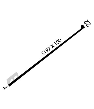
  • Runway Identifications
    Runway Identification: 04/22
    Length: 5197 ft
    Width: 100 ft
    Surface: ASPHALT-GOOD CONDITION
    Edge lights: Medium Intensity

    Treatment: NONE

     Runway: 04   Runway: 22
    Mag heading: 41°Mag heading: 221°
    Rwy Slope: .18% UpRwy Slope: -.18% Down
    Approach: Approach:
    Pattern: Right TrafficPattern: Left Traffic
    Markings: NONPRECISION INSTRUMENTMarkings: NONPRECISION INSTRUMENT
    Marking Condition: GOODMarking Condition: GOOD
    Arresting Dev: Arresting Dev:
    Lat & Long: N1959.8  W15540.4Lat. & Long.: N2000.3  W15539.7
    Elev: 2661.8 ft. MSLElev: 2671.1 ft. MSL
    TCH: 43 ft. AGLTCH: 35 ft. AGL
    Visual Glide Path: 2.50 degreesVisual Glide Path: 3.00 degrees
    Displaced Threshold: NoDisplaced Threshold: No
    Touchdown Zone: YESTouchdown Zone: YES
    Touchdown Elev.: 2670.6 feetTouchdown Elev.: 2671.1 feet
    Visual Glide Slope: 4-BOX VASI ON RIGHT SIDE OF RUNWAY; RY 4 VASI UNUSBL BYD 8 DEG LEFT CNTRLN.Visual Glide Slope: 4-BOX VASI ON LEFT SIDE OF RUNWAY; RY 22 VASI UNUSBL BYD 5 DEG L/R CNTRLN.
    RVR Equipment: RVR Equipment:
    RVV Equipment: NORVV Equipment: NO
    Approach Lights: Approach Lights:
    REIL: YESREIL: YES
    Centerline Lights: NOCenterline Lights: NO
    Touchdown lights: NOTouchdown lights: NO
    Runway Category: Runway with a Non-precision Approach having visibility minimums greater than 3/4 mileRunway Category: Runway with a Non-precision Approach having visibility minimums greater than 3/4 mile
    Declared Distances: Declared Distances:
    Obstructions: Obstructions: FENCE
    Marked: Marked: NOT Marked/Lighted
    Clearance slope: 34:1Clearance slope: 11:1
    Obstruction height: Obstruction height: 9 feet AGL
    Dist. from runway: Dist. from runway: 300 feet
    Centerline offset: Centerline offset:
    Comments: Comments: +4' TRRN 165' SE CNTRLN & 0' FM THR BOTH ENDS RWY 4-22.
    C:10/P: