Click here for more info on on SMS!

PHMK

MOLOKAI
KAUNAKAKAI
HI
Time Zone: Hawaii
Lat: N 2109.2
Long: W 15705.8
Elev: 454
Var: -11
Longest Runway: 4494
Dept. ATIS: 128.2
Arr. ATIS: 128.2
Ground: 121.9
Tower: 125.7

FBO & Flight Services info for PHMK

FBOs: Update your Fuel Prices

AIRPORTPh: 808-872-3808
-
Freq: 125.7
If you are an FBO, call 1-203-262-1700 to update your info or email: FltPlan.Advertising@garmin.com
Advertise your FBO on FltPlan.com

Runway & Approach Info for PHMK
Rwy
Length
Land Dist**
Approach*
  Rwy
Length
Land Dist**
Approach*
05
4494x100  4494'          
 
  
23
  4494x100  3901'          
 
17
3118x100  2692'          
 
  
35
  3118x100  3118'          
 
 * only ILS, LOC, LDA, and SDF approaches to a specific runway are shown
** For any Declared Landing Distance Available, please see A/FD or Approach plates
Runway Weight Capability (lbs.) Help
Runway IDSingle WheelDouble WheelDouble Tandem WheelDual Double Wheel
05/2330,00048,000N/AN/A
17/3513,000N/AN/AN/A
These numbers are Advisory and are not limits.   The Airport Manager should have more accurate Weight Limits
Approach Charts
Approaches    
Current Weather/Notams
Customs Information Send updates to Support@FltPlan.com
Customs Not Available
Database effective 05/16/2024
Airport Diagram of PHMK
Airport Diagram might not be current.

Facility Name: MOLOKAI
City Name: KAUNAKAKAI
County: MAUI
State abbrev: HI
State Name: HAWAII
   
Ownership: PUBLICLY OWNED
Use: OPEN TO THE PUBLIC
Owner's Name: HAWAII STATE AIRPORTS DIV
Address: HONOLULU INTL ARPT
 HONOLULU, HI 96819
Owner's Phone: 808-836-6432
  
Manager's Name: MARVIN MONIZ
Address: KAHULUI ARPT
 KAHULUI, HI 96732
Phone: 808-872-3808
   
FAA Region: WESTERN-PACIFIC
FAA Field Office: HNL


Sunrise / Sunset times for MOLOKAI

DateSunriseSunset
04/22/24 Monday6:0318:50
04/23/24 Tuesday6:0318:51
04/24/24 Wednesday6:0218:51
04/25/24 Thursday6:0118:52
04/26/24 Friday6:0018:52
04/27/24 Saturday6:0018:52
04/28/24 Sunday5:5918:53
04/29/24 Monday5:5818:53
04/30/24 Tuesday5:5818:53
05/01/24 Wednesday5:5718:54
05/02/24 Thursday5:5718:54
05/03/24 Friday5:5618:55
05/04/24 Saturday5:5518:55
05/05/24 Sunday5:5518:55

Airport Facilities

Airport Attendance Schedule7 Days A Week 0500-2015
Airport Status OPERATIONAL (This Status can change at any time - please check NOTAMS)
Airport Lighting Schedule
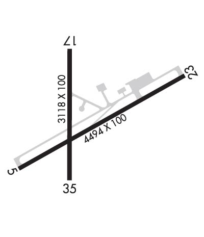
WHEN ATCT CLSD ACTVT MIRL RY 05/23 AND RY 17/35, REIL RY 05 - CTAF.
Airport Storage AvailableTie Downs
Extra Services AvailableAir Freight, Cargo Handling
Wind IndicatorYES - (lighted)
Control TowerYES
CTAF Frequency125.700
Unicom Frequency
Rotating Beacon ColorWG
Segmented CircleYES
Landing FeeNO

Airport Inspection Data

Airport InspectedFEDERAL - performed by FAA AIRPORTS FIELD PERSONNEL
Inspection Date02/17/2022

Airport Services

Type of Fuel AvailableNone
Airframe Repair ServiceNone
Power Plant Repair ServiceNone

Geographic Data

LatitudeN2109.2
LongitudeW15705.8 (ESTIMATED)
Arpt Elevation453ft (SURVEYED)
Magnetic Variation11E
6 miles NWof KAUNAKAKAI
Traffic Pattern Altitude
Sectional ChartHAWAIIAN ISLANDS

Aircraft Data

Operations (Reported)YearlyAvg. Daily
General Aviation Transient 362810
General Aviation Local 7032
Air Taxi 2187360
Commerical 00
Commuter 00
Military 5021
Aircraft based on Field
General Aviation Singles 6
General Aviation Multi 0
Jet Aircraft 0
General Aviation Helicopters 0
Military Aircraft 0
Gliders 0
Ultralights 0

FAA Services

FSS on field NO
FSS tie-in HONOLULU
FSS Phone 1-800-WX-BRIEF
Who issues Notams MKK
Notam D service at airport YES
ARTCC Name HONOLULU CONTROL FACILITY

Federal Status

Airport CertificationAIRPORT RECEIVING SCHEDULED AIR CARRIER SERVICE FROM CARRIERS CERTIFICATED BY THE CIVIL AERONAUTICS BOARD; ARPT CLOSED TO AIR CARRIER OPS WITH 10 OR MORE PASSENGER SEATS 1930-0600 EXCEPT PPR, CALL 808-567-9660/9663.
Aircraft Rescue & Firefighting IndexAIRPORT HAS A CERTIFICATE UNDER CFR PART 139
Airport of EntryNo
Custom Landing RightsNo
Joint Civil/MilitaryNo
Military Landing rightsYES

Federal Agreements

NATIONAL PLAN OF INTEGRATED AIRPORT SYSTEMS (NPIAS)
GRANT AGREEMENTS UNDER FAAP/ADAP/AIP
ASSURANCES PURSUANT TO TITLE VI, CIVIL RIGHTS ACT OF 1964
AGREEMENT UNDER DLAND OR DCLA HAS EXPIRED.

Remarks

THIS AIRPORT HAS BEEN SURVEYED BY THE NATIONAL GEODETIC SURVEY.
24 HRS PPR FOR DIVISION 1.1,1.2,1.3 EXPLOSIVES AND 4 HRS PPR FOR OTHER HAZARDOUS MATERIAL IN/OUT OF ARPT CTC 808-567-6140/6008.
MTN APPROXIMATELY 1280' MSL LCTD 2.8 NM FROM RWY 05 THR ON CNTRLN EXTDD.
BE ALERT TO EGRETS AND PIGEONS ON & INVOF ARPT.
LARGE ACFT WITH WINGSPAN GREATER THAN 78 FT MAY NOT USE TWY A OR RY 05/23 FOR SIMULTANEOUS OPNS.
(E94) LAWRS AVBL FROM TWR PERSONNEL 0600-1900 LCL.
STANDING WATER/PONDING ON RY 17/35 NEAR TWY ECHO DURING INCLEMENT WEATHER.
FOR CD WHEN ATCT IS CLSD CTC HONOLULU CONTROL FACILITY AT 808-840-6262.
(CONTACT TITLE) ARPT OPNS/MAINT/AOM/MR. ANTONE KALILIKANE (808) 567-9660.
Airport Communications & Frequencies:
ATIS Frequencies:   Hours(local) of Operation:
128.2
MOLOKAI Tower Frequencies:   Hours(local) of operation: 0600-1830   
125.7
306.2
MOLOKAI Ground Frequencies:
121.9
Emergency Frequencies:
121.5
243.0
CTAF Frequency:
125.700
Remarks
  • APCH/DEP SVC PRVDD BY HONOLULU CONTROL FACILITY (ZHN) ON FREQS 124.1/317.5 (MOUNT HALEAKALA RCAG).
  • Runway Identifications
    Runway Identification: 05/23
    Length: 4494 ft
    Width: 100 ft
    Surface: ASPHALT-GOOD CONDITION
    Edge lights: Medium Intensity

    Treatment: GROOVED
    Weight: PCN 28 /F/A/W/T

     Runway: 05   Runway: 23
    Mag heading: 49°Mag heading: 229°
    Rwy Slope: .37% UpRwy Slope: -.37% Down
    Approach: Approach:
    Pattern: Left TrafficPattern: Left Traffic
    Markings: NONPRECISION INSTRUMENTMarkings: NONPRECISION INSTRUMENT
    Marking Condition: GOODMarking Condition: GOOD
    Arresting Dev: Arresting Dev:
    Lat & Long: N2109.0  W15706.1Lat. & Long.: N2109.3  W15705.4
    Elev: 437.1 ft. MSLElev: 453.9 ft. MSL
    TCH: 49 ft. AGLTCH:
    Visual Glide Path: 4.00 degreesVisual Glide Path:
    Displaced Threshold: NoDisplaced Threshold: 593 feet
    Touchdown Zone: YESTouchdown Zone: YES
    Touchdown Elev.: 441.2 feetTouchdown Elev.: 445.2 feet
    Visual Glide Slope: 4-Light PAPI on LEFT side of Runway; PAPI NOT AUTHORIZED 1.8 NM BYD LDG THLD DUE TO RAPIDLY RISING TERRAIN.Visual Glide Slope:
    RVR Equipment: RVR Equipment:
    RVV Equipment: NORVV Equipment: NO
    Approach Lights: Approach Lights:
    REIL: YESREIL: NO
    Centerline Lights: NOCenterline Lights: NO
    Touchdown lights: NOTouchdown lights: NO
    Runway Category: Runway with a Visual ApproachRunway Category: Runway with a Visual Approach
    Declared Distances: TORA:4494' TODA:4494' ASDA:4494' LDA:4494'Declared Distances: TORA:4494' TODA:4494' ASDA:4494' LDA:3901'
    Obstructions: Obstructions: BRUSH; BRUSH 1900' FROM DSPLCD THR.
    Marked: Marked: NOT Marked/Lighted
    Clearance slope: 50:1Clearance slope: 17:1; APCH RATIO FROM DSPLCD THLD 23:1.
    Obstruction height: Obstruction height: 23 feet AGL
    Dist. from runway: Dist. from runway: 400 feet
    Centerline offset: Centerline offset:
    Comments: Comments:
    Runway Identification: 17/35
    Length: 3118 ft
    Width: 100 ft
    Surface: ASPHALT-FAIR CONDITION
    Edge lights: Medium Intensity

    Treatment: NONE
    Weight: PCN 4 /F/B/W/T

     Runway: 17   Runway: 35
    Mag heading: 169°Mag heading: 349°
    Rwy Slope: -.58% DownRwy Slope: .58% Up
    Approach: Approach:
    Pattern: Left TrafficPattern: Left Traffic
    Markings: BASICMarkings: BASIC
    Marking Condition: GOODMarking Condition: GOOD
    Arresting Dev: Arresting Dev:
    Lat & Long: N2109.4  W15705.9Lat. & Long.: N2108.9  W15705.9
    Elev: 448.4 ft. MSLElev: 430.3 ft. MSL
    TCH: TCH:
    Visual Glide Path: Visual Glide Path:
    Displaced Threshold: 426 feetDisplaced Threshold: No
    Touchdown Zone: YESTouchdown Zone: YES
    Touchdown Elev.: 442.5 feetTouchdown Elev.: 446.8 feet
    Visual Glide Slope: Visual Glide Slope:
    RVR Equipment: RVR Equipment:
    RVV Equipment: NORVV Equipment: NO
    Approach Lights: Approach Lights:
    REIL: NOREIL: NO
    Centerline Lights: NOCenterline Lights: NO
    Touchdown lights: NOTouchdown lights: NO
    Runway Category: Runway with a Visual ApproachRunway Category: Runway with a Visual Approach
    Declared Distances: TORA:3118' TODA:3118' ASDA:3118' LDA:2692'Declared Distances: TORA:3118' TODA:3118' ASDA:3118' LDA:3118'
    Obstructions: FENCEObstructions: FENCE
    Marked: NOT Marked/LightedMarked: NOT Marked/Lighted
    Clearance slope: APCH RATIO 23:1 FROM DSPLCD THLD.Clearance slope: 12:1
    Obstruction height: 12 feet AGLObstruction height: 4 feet AGL
    Dist. from runway: 80 feetDist. from runway: 248 feet
    Centerline offset: Centerline offset:
    Comments: Comments:
    C:31/P: