
| |||||
|
| Rwy | Rwy | |||||||
| 2700x75 | 2700' | 2700x75 | 2700' | |||||
| Runway ID | Single Wheel | Double Wheel | Double Tandem Wheel | Dual Double Wheel |
| 05/23 | 17,000 | N/A | N/A | N/A |
| These numbers are Advisory and are not limits. The Airport Manager should have more accurate Weight Limits | ||||
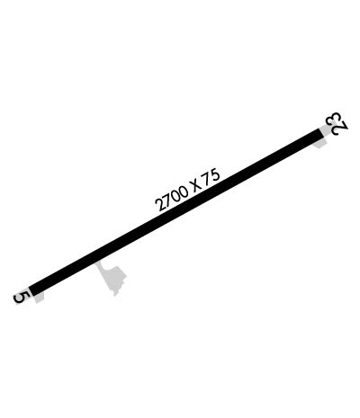 Airport Diagram might not be current. | |
| Facility Name: | KALAUPAPA |
| City Name: | KALAUPAPA |
| County: | KALAWAO |
| State abbrev: | HI |
| State Name: | HAWAII |
| Ownership: | PUBLICLY OWNED |
| Use: | OPEN TO THE PUBLIC |
| Owner's Name: | HAWAII STATE AIRPORTS DIVISION |
| Address: | 400 RODGERS BLVD SUITE 700 |
| HONOLULU, HI 96819 | |
| Owner's Phone: | 808-838-8701 |
| Manager's Name: | MARVIN MONIZ; ARPT OPNS/MAINT/ MAN/ADM/-MR. ANTONE KALILIKANE MOLOKAI (808) 567-9660. |
| Address: | KAHULUI AIRPORT |
| KAHULUI, HI 96732 | |
| Phone: | 808-872-3830 |
| FAA Region: | WESTERN-PACIFIC |
| FAA Field Office: | HNL |
| Date | Sunrise | Sunset |
|---|---|---|
| 04/24/24 Wednesday | 6:01 | 18:51 |
| 04/25/24 Thursday | 6:01 | 18:51 |
| 04/26/24 Friday | 6:00 | 18:51 |
| 04/27/24 Saturday | 5:59 | 18:52 |
| 04/28/24 Sunday | 5:59 | 18:52 |
| 04/29/24 Monday | 5:58 | 18:53 |
| 04/30/24 Tuesday | 5:57 | 18:53 |
| 05/01/24 Wednesday | 5:57 | 18:53 |
| 05/02/24 Thursday | 5:56 | 18:54 |
| 05/03/24 Friday | 5:55 | 18:54 |
| 05/04/24 Saturday | 5:55 | 18:55 |
| 05/05/24 Sunday | 5:54 | 18:55 |
| 05/06/24 Monday | 5:54 | 18:55 |
| 05/07/24 Tuesday | 5:53 | 18:56 |
| Airport Attendance Schedule | MON-FRI 0700-1530 |
| Airport Status | OPERATIONAL (This Status can change at any time - please check NOTAMS) |
| Airport Lighting Schedule | ACTVT MIRL RWY 05/23 MED INTST ONLY - CTAF. PAPI RWY 05 DAYTIME VFR USE ONLY. |
| Airport Storage Available | NONE |
| Extra Services Available | NONE |
| Wind Indicator | YES - (lighted) |
| Control Tower | NO |
| CTAF Frequency | 122.900 |
| Unicom Frequency | |
| Rotating Beacon Color | WG |
| Segmented Circle | YES |
| Landing Fee | NO |
| Airport Inspected | STATE - performed by PRIVATE CONTRACT PERSONNEL |
| Inspection Date | 01/31/2022 |
| Type of Fuel Available | None |
| Airframe Repair Service | NONE |
| Power Plant Repair Service | NONE |
| Latitude | N2112.7 |
| Longitude | W15658.4 (ESTIMATED) |
| Arpt Elevation | 23ft (SURVEYED) |
| Magnetic Variation | 11E |
| 2 miles N | of KALAUPAPA |
| Traffic Pattern Altitude | 776 |
| Sectional Chart | HAWAIIAN ISLANDS |
| Operations (Reported) | Yearly | Avg. Daily |
|---|---|---|
| General Aviation Transient | 400 | 1 |
| General Aviation Local | 200 | 1 |
| Air Taxi | 2394 | 7 |
| Commerical | 0 | 0 |
| Commuter | 0 | 0 |
| Military | 300 | 1 |
| Aircraft based on Field | |
|---|---|
| General Aviation Singles | 0 |
| General Aviation Multi | 0 |
| Jet Aircraft | 0 |
| General Aviation Helicopters | 0 |
| Military Aircraft | 0 |
| Gliders | 0 |
| Ultralights | 0 |
| FSS on field | NO |
| FSS tie-in | HONOLULU |
| FSS Phone | 1-800-WX-BRIEF |
| Who issues Notams | MKK |
| Notam D service at airport | YES |
| ARTCC Name | HONOLULU CONTROL FACILITY |
| Airport Certification | |
| Aircraft Rescue & Firefighting Index | None |
| Airport of Entry | No |
| Custom Landing Rights | No |
| Joint Civil/Military | No |
| Military Landing rights | YES |
| NATIONAL PLAN OF INTEGRATED AIRPORT SYSTEMS (NPIAS) |
| GRANT AGREEMENTS UNDER FAAP/ADAP/AIP |
| ASSURANCES PURSUANT TO TITLE VI, CIVIL RIGHTS ACT OF 1964 |
| SEE AREA NOTICES - TRAFFIC ADVISORIES AT NON-TOWER ARPTS. |
| 24 HRS PPR FOR DIVISION 1.1,1.2,1.3 EXPLOSIVES AND 4 HRS PPR FOR OTHER HAZARDOUS MATERIAL IN/OUT OF ARPT CTC 808-567-9660/9663. |
| PPR FM ST DEPT OF HEALTH COMMUNICABLE DISEASE DIV TO ENTER SETTLEMENT AREA PHONE HONOLULU 808-586-4580. |
| DEER & WILD ANIMALS ON & INVOF ARPT AT NIGHT. |
| OCT-MAY LARGE WAVES IMPACTING SHORELINE RESULTING IN SALT WATER SPRAYS 40 FT HIGH. |
| FOR CD CTC HONOLULU CONTROL FACILITY AT 808-840-6262. |
Airport Communications & Frequencies:
| |||||||
| Runway: 05 | Runway: 23 | ||
| Mag heading: | 50° | Mag heading: | 230° |
| Rwy Slope: | -.04% Down | Rwy Slope: | .04% Up |
| Approach: | Approach: | ||
| Pattern: | Left Traffic | Pattern: | Right Traffic |
| Markings: | BASIC | Markings: | BASIC |
| Marking Condition: | FAIR | Marking Condition: | FAIR |
| Arresting Dev: | Arresting Dev: | ||
| Lat & Long: | N2112.6 W15658.6 | Lat. & Long.: | N2112.8 W15658.2 |
| Elev: | 23.9 ft. MSL | Elev: | 22.8 ft. MSL |
| TCH: | 19 ft. AGL | TCH: | |
| Visual Glide Path: | 3.00 degrees | Visual Glide Path: | |
| Displaced Threshold: | No | Displaced Threshold: | No |
| Touchdown Zone: | YES | Touchdown Zone: | YES |
| Touchdown Elev.: | 23.9 feet | Touchdown Elev.: | 23.9 feet |
| Visual Glide Slope: | 2-Light PAPI on LEFT side of Runway; PAPI UNUSBL BYD 2.2 NM. TERRAIN PENETRATES PAPI SAFETY SLOPE AT 2.7 NM. | Visual Glide Slope: | |
| RVR Equipment: | RVR Equipment: | ||
| RVV Equipment: | NO | RVV Equipment: | NO |
| Approach Lights: | Approach Lights: | ||
| REIL: | NO | REIL: | NO |
| Centerline Lights: | NO | Centerline Lights: | NO |
| Touchdown lights: | NO | Touchdown lights: | NO |
| Runway Category: | Runway with a Visual Approach | Runway Category: | Runway with a Visual Approach |
| Declared Distances: | Declared Distances: |