
| ||||||||||||||||||||||||||||||||||||||||||||||||||||||||||||||||||||
| ||||||||||||||||||||||||||||||||||||||||||||||||||||||||||||||||||||
| ||||||||||||||||||||||||||||||||||||||||||||||||||||||||||||||||||||
| ||||||||||||||||||||||||||||||||||||||||||||||||||||||||||||||||||||
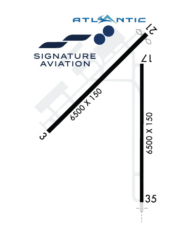
| Rwy | Rwy | |||||||
| 6500x150 | 6500' | 6500x150 | 6295' | |||||
| 6500x150 | 6500' | 6500x150 | 6500' | 110.90 - 349° | ||||
| Runway ID | Single Wheel | Double Wheel | Double Tandem Wheel | Dual Double Wheel |
| 03/21 | 75,000 | 200,000 | 350,000 | 730,000 |
| 17/35 | 75,000 | 175,000 | 250,000 | 630,000 |
| H1 | N/A | N/A | N/A | N/A |
| H2 | N/A | N/A | N/A | N/A |
| H3 | N/A | N/A | N/A | N/A |
| These numbers are Advisory and are not limits. The Airport Manager should have more accurate Weight Limits | ||||
 Airport Diagram might not be current. | |
| Facility Name: | LIHUE |
| City Name: | LIHUE |
| County: | KAUAI |
| State abbrev: | HI |
| State Name: | HAWAII |
| Ownership: | PUBLICLY OWNED; DIST. MGR; STATE OF HAWAII DEPT. OF TRANSPORTATION AIRPORTS DIV. |
| Use: | OPEN TO THE PUBLIC |
| Owner's Name: | HAWAII ST ARPTS DIV |
| Address: | HONOLULU INTL ARPT |
| HONOLULU, HI 96819 | |
| Owner's Phone: | 808-838-8600 |
| Manager's Name: | CRAIG H. DAVIS |
| Address: | 3901 MOKULELE LP BOX 6 |
| LIHUE, HI 96766 | |
| Phone: | 808-274-3800 |
| FAA Region: | WESTERN-PACIFIC |
| FAA Field Office: | HNL |
| Date | Sunrise | Sunset |
|---|---|---|
| 04/25/24 Thursday | 6:09 | 19:01 |
| 04/26/24 Friday | 6:08 | 19:02 |
| 04/27/24 Saturday | 6:08 | 19:02 |
| 04/28/24 Sunday | 6:07 | 19:03 |
| 04/29/24 Monday | 6:06 | 19:03 |
| 04/30/24 Tuesday | 6:06 | 19:03 |
| 05/01/24 Wednesday | 6:05 | 19:04 |
| 05/02/24 Thursday | 6:04 | 19:04 |
| 05/03/24 Friday | 6:04 | 19:05 |
| 05/04/24 Saturday | 6:03 | 19:05 |
| 05/05/24 Sunday | 6:03 | 19:06 |
| 05/06/24 Monday | 6:02 | 19:06 |
| 05/07/24 Tuesday | 6:01 | 19:06 |
| 05/08/24 Wednesday | 6:01 | 19:07 |
| Airport Attendance Schedule | 7 Days A Week 0600-2200 |
| Airport Status | OPERATIONAL (This Status can change at any time - please check NOTAMS) |
| Airport Lighting Schedule | WHEN ATCT CLSD ACTVT MALSR RWY 35; REIL RWYS 03, 17, & 21; PAPI RWYS 03, 17, 21, & 35; MIRL RWY 03/21; HIRL RWY 17/35; TWY LGTS - CTAF. |
| Airport Storage Available | Tie Downs |
| Extra Services Available | Air Freight, Crop Dusting, Cargo Handling, Charter |
| Wind Indicator | YES - (lighted) |
| Control Tower | YES |
| CTAF Frequency | 118.900 |
| Unicom Frequency | |
| Rotating Beacon Color | WG |
| Segmented Circle | YES |
| Landing Fee | NO |
| Airport Inspected | FEDERAL - performed by FAA AIRPORTS FIELD PERSONNEL |
| Inspection Date | 09/22/2023 |
| Type of Fuel Available | Grade 100, JET A (freeze point -40C); -10100 OCTANE FUEL AVBL 0900-1700. FOR JET A FUEL CALL 1-800-776-2138 OR 1-800-821-3122. |
| Airframe Repair Service | MINOR |
| Power Plant Repair Service | MINOR; HELI MAJOR. |
| Latitude | N2158.6 |
| Longitude | W15920.3 (ESTIMATED) |
| Arpt Elevation | 152ft (SURVEYED) |
| Magnetic Variation | 11E |
| 2 miles E | of LIHUE |
| Traffic Pattern Altitude | TPA SINGLE ENGINE 1000 (851) MULTI ENGINE 1500 (1351). |
| Sectional Chart | HAWAIIAN ISLANDS |
| Operations (Reported) | Yearly | Avg. Daily |
|---|---|---|
| General Aviation Transient | 4086 | 11 |
| General Aviation Local | 15101 | 41 |
| Air Taxi | 74280 | 204 |
| Commerical | 32625 | 89 |
| Commuter | 0 | 0 |
| Military | 979 | 3 |
| Aircraft based on Field | |
|---|---|
| General Aviation Singles | 19 |
| General Aviation Multi | 5 |
| Jet Aircraft | 0 |
| General Aviation Helicopters | 22 |
| Military Aircraft | 0 |
| Gliders | 0 |
| Ultralights | 0 |
| FSS on field | NO |
| FSS tie-in | HONOLULU |
| FSS Phone | 1-800-WX-BRIEF |
| Who issues Notams | LIH |
| Notam D service at airport | YES |
| ARTCC Name | HONOLULU CONTROL FACILITY |
| Airport Certification | AIRPORT RECEIVING SCHEDULED AIR CARRIER SERVICE FROM CARRIERS CERTIFICATED BY THE CIVIL AERONAUTICS BOARD; |
| Aircraft Rescue & Firefighting Index | AIRPORT HAS A CERTIFICATE UNDER CFR PART 139 |
| Airport of Entry | No |
| Custom Landing Rights | YES |
| Joint Civil/Military | No |
| Military Landing rights | YES |
| NATIONAL PLAN OF INTEGRATED AIRPORT SYSTEMS (NPIAS) |
| GRANT AGREEMENTS UNDER FAAP/ADAP/AIP |
| ASSURANCES PURSUANT TO TITLE VI, CIVIL RIGHTS ACT OF 1964 |
| STADIUM FLOOD LIGHTS 125 FT AGL/282 FT MSL/ 2400 FT SW FROM RWY 03 THR. |
| RWY 17/35 WGT LMT DC10-10 340000 LBS; DC10-30 430000 LBS. |
| 405 FT OF RWY 17/35 500 FT SOUTH OF TWY D & RWY 17/35 INT NOT VSB FM ATCT. |
| HELICOPTER PADS 1-20 LCTD W OF CONTROL TOWER. |
| MISC 2 OF 3: ACFT NEEDING ENG RUNUPS FOR OTR THAN NML START-UP AND TAXI OUT ARE RQRD TO COORD THESE RUNUPS WITH OPS AT 808-651-6255. NML RUNUP AREA IS ON TWY ALPHA NORTH OF TWY B AND ALPHA INT. ACFT ORIENTATION IS DEPENDENT ON WIND AND TWR APVL. |
| MISC 3 OF 3: POWER SETTING WILL NOT CAUSE DAMAGE TO LIGHTS AND SIGNS, IF RUN MAY CAUSE DAMAGE AN ALTERNATE LOCATION WILL BE SELECTED. |
| MISC 1 OF 3: PPR FOR PARKING ALL TRANSIENT ACFT, CALL ARPT OPS CONTROL (808)651-6255; FAX (808) 241-3939 BTN 1700Z 0230Z, OTHER TIMES (808) 274-3814. MILITARY/CIVILIAN ACFT CARRYING MUNITIONS/HAZMAT MUST COORDINATE ITINERARY NLT 24 HRS PRIOR TO ARRIVAL. |
| EXTENSIVE LARGE AND SMALL BIRD ACTIVITY INVOF RYS INCLUDING THE NENE GOOSE. |
| FOR CD WHEN ATCT IS CLSD CTC HONOLULU CONTROL FACILITY AT 808-840-6262. |
| INTXN DEPS FM TWY D ON RY 17/35 NOT AUTHORIZED. |
| PPR FOR TRANSPORTATION OF DIV 1.1, 1.2, 1.3, 1.4 EXPLOSIVES AND HAZMAT IN AND OUT OF ARPT. CALL ARPT OPS AT 808-651-6255. |
| MILITARY ACFT MAKE FUEL ARRANGEMENTS BEFORE ARRIVAL. |
| DUE TO NONVISIBILITY ATCT UNABLE TO PROVIDE ATC SVC BTN ACFT AND/OR VEHICLES ON TWY B FM 220 FT TO 500 FT S OF TWY D. |
| RWY 17/3 5 DIST RMNG SIGNS LEFT SIDE OF RWY 35. |
Airport Communications & Frequencies:
| |||||||||||||||||||||||||
| Runway: 03 | Runway: 21 | ||
| Mag heading: | 34° | Mag heading: | 214° |
| Rwy Slope: | -1.11% Down | Rwy Slope: | 1.11% Up |
| Approach: | Approach: | ||
| Pattern: | Right Traffic | Pattern: | Left Traffic |
| Markings: | NONPRECISION INSTRUMENT | Markings: | NONPRECISION INSTRUMENT |
| Marking Condition: | GOOD | Marking Condition: | GOOD |
| Arresting Dev: | Arresting Dev: | ||
| Lat & Long: | N2158.4 W15920.9 | Lat. & Long.: | N2159.1 W15920.1 |
| Elev: | 152.3 ft. MSL | Elev: | 80.2 ft. MSL |
| TCH: | 46 ft. AGL | TCH: | 45 ft. AGL |
| Visual Glide Path: | 3.00 degrees | Visual Glide Path: | 3.00 degrees |
| Displaced Threshold: | No | Displaced Threshold: | 205 feet |
| Touchdown Zone: | YES | Touchdown Zone: | YES |
| Touchdown Elev.: | 152.4 feet | Touchdown Elev.: | 118.0 feet |
| Visual Glide Slope: | 4-Light PAPI on LEFT side of Runway; UNUSBL BYD 1.5 NM AND 7 DEGS LEFT OF CNTRLN AND OFFSET 9.5 DEG E OF CNTRLN DUE TO RAPIDLY RISING TRRN. | Visual Glide Slope: | 4-Light PAPI on LEFT side of Runway |
| RVR Equipment: | RVR Equipment: | ||
| RVV Equipment: | NO | RVV Equipment: | NO |
| Approach Lights: | Approach Lights: | ||
| REIL: | YES | REIL: | YES |
| Centerline Lights: | NO | Centerline Lights: | NO |
| Touchdown lights: | NO | Touchdown lights: | NO |
| Runway Category: | Runway with a Visual Approach | Runway Category: | Runway with a Non-precision Approach having visibility minimums greater than 3/4 mile |
| Declared Distances: | TORA:6500' TODA:6500' ASDA:6500' LDA:6500' | Declared Distances: | TORA:6500' TODA:6500' ASDA:6500' LDA:6295' |
| Obstructions: | Obstructions: | TREE | |
| Marked: | Marked: | NOT Marked/Lighted | |
| Clearance slope: | 50:1 | Clearance slope: | 50:1 |
| Obstruction height: | Obstruction height: | 4 feet AGL | |
| Dist. from runway: | Dist. from runway: | 200 feet | |
| Centerline offset: | Centerline offset: | 100 feet right of centerline | |
| Comments: | Comments: |
| Runway: 17 | Runway: 35 | ||
| Mag heading: | 169° | Mag heading: | 349° |
| Rwy Slope: | .00% Up | Rwy Slope: | .00% Down |
| Approach: | Approach: | ILS/DME | |
| Pattern: | Left Traffic | Pattern: | Right Traffic |
| Markings: | PRECISION INSTRUMENT | Markings: | PRECISION INSTRUMENT |
| Marking Condition: | GOOD | Marking Condition: | GOOD |
| Arresting Dev: | Arresting Dev: | ||
| Lat & Long: | N2158.9 W15920.2 | Lat. & Long.: | N2157.8 W15920.2 |
| Elev: | 91.2 ft. MSL | Elev: | 91.3 ft. MSL |
| TCH: | 54 ft. AGL | TCH: | 55 ft. AGL |
| Visual Glide Path: | 3.00 degrees | Visual Glide Path: | 3.00 degrees |
| Displaced Threshold: | No | Displaced Threshold: | No |
| Touchdown Zone: | YES | Touchdown Zone: | YES |
| Touchdown Elev.: | 98.4 feet | Touchdown Elev.: | 95.8 feet |
| Visual Glide Slope: | 4-Light PAPI on LEFT side of Runway; UNUSBL BYD 5 DEGS RIGHT OF CNTRLN. | Visual Glide Slope: | 4-Light PAPI on LEFT side of Runway |
| RVR Equipment: | RVR Equipment: | ||
| RVV Equipment: | NO | RVV Equipment: | NO |
| Approach Lights: | Approach Lights: | MALSR - 1,400 foot medium intensity approach lighting system with runway alignment indicator lights | |
| REIL: | YES | REIL: | NO |
| Centerline Lights: | NO | Centerline Lights: | NO |
| Touchdown lights: | NO | Touchdown lights: | NO |
| Runway Category: | Runway with a Non-precision Approach having visibility minimums greater than 3/4 mile | Runway Category: | Precision Instrument Runway |
| Declared Distances: | TORA:6500' TODA:6500' ASDA:6500' LDA:6500' | Declared Distances: | TORA:6500' TODA:6500' ASDA:6500' LDA:6500' |


