
| ||||||||||||||||||||||||||||||||||||||||||||||||||||||||||||||||||||
| ||||||||||||||||||||||||||||||||||||||||||||||||||||||||||||||||||||
| ||||||||||||||||||||||||||||||||||||||||||||||||||||||||||||||||||||
| ||||||||||||||||||||||||||||||||||||||||||||||||||||||||||||||||||||
| ||||||||||||||||||||||||||||||||||||||||||||||||||||||||||||||||||||
| ||||||||||||||||||||||||||||||||||||||||||||||||||||||||||||||||||||
| Rwy | Rwy | |||||||
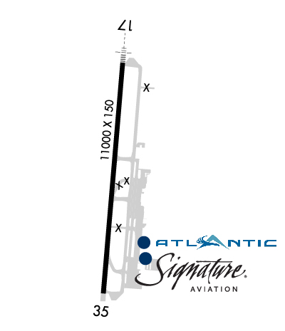
| 11000x150 | 11000' | 109.70 - 173° | 11000x150 | 11000' | ||||
| Runway ID | Single Wheel | Double Wheel | Double Tandem Wheel | Dual Double Wheel |
| 17/35 | 75,000 | 200,000 | 400,000 | 850,000 |
| These numbers are Advisory and are not limits. The Airport Manager should have more accurate Weight Limits | ||||
 Airport Diagram might not be current. | |
| Facility Name: | ELLISON ONIZUKA KONA INTL AT KEAHOLE |
| City Name: | KAILUA/KONA |
| County: | HAWAII |
| State abbrev: | HI |
| State Name: | HAWAII |
| Ownership: | PUBLICLY OWNED |
| Use: | OPEN TO THE PUBLIC |
| Owner's Name: | HAWAII ST ARPTS DIV |
| Address: | HONOLULU INTL ARPT |
| HONOLULU, HI 96819 | |
| Owner's Phone: | 808-838-8600 |
| Manager's Name: | CHAUNCEY WONG YUEN |
| Address: | 73-200 KUPIPI ST, KONA INTL AIRPORT AT KEAHOLE |
| KAILUA-KONA, HI 96740-2645 | |
| Phone: | 808-327-9520 |
| FAA Region: | WESTERN-PACIFIC |
| FAA Field Office: | HNL |
| Date | Sunrise | Sunset |
|---|---|---|
| 04/25/24 Thursday | 5:59 | 18:46 |
| 04/26/24 Friday | 5:58 | 18:46 |
| 04/27/24 Saturday | 5:57 | 18:46 |
| 04/28/24 Sunday | 5:57 | 18:47 |
| 04/29/24 Monday | 5:56 | 18:47 |
| 04/30/24 Tuesday | 5:55 | 18:47 |
| 05/01/24 Wednesday | 5:55 | 18:48 |
| 05/02/24 Thursday | 5:54 | 18:48 |
| 05/03/24 Friday | 5:54 | 18:49 |
| 05/04/24 Saturday | 5:53 | 18:49 |
| 05/05/24 Sunday | 5:53 | 18:49 |
| 05/06/24 Monday | 5:52 | 18:50 |
| 05/07/24 Tuesday | 5:52 | 18:50 |
| 05/08/24 Wednesday | 5:51 | 18:50 |
| Airport Attendance Schedule | 7 Days A Week 0600-2200 |
| Airport Status | OPERATIONAL (This Status can change at any time - please check NOTAMS) |
| Airport Lighting Schedule | ACTVT MALSR RWY 17; HIRL RWY 17/35 & TWY LGTS - CTAF. |
| Airport Storage Available | Tie Downs |
| Extra Services Available | Air Freight, Cargo Handling, Flight Instruction, Aircraft Rental |
| Wind Indicator | YES - (lighted) |
| Control Tower | YES |
| CTAF Frequency | 120.300 |
| Unicom Frequency | |
| Rotating Beacon Color | WG |
| Segmented Circle | YES |
| Landing Fee | NO |
| Airport Inspected | FEDERAL - performed by FAA AIRPORTS FIELD PERSONNEL |
| Inspection Date | 01/24/2024 |
| Type of Fuel Available | Grade 100, JET A (freeze point -40C); -10JET-A & 100 OCTANE FUEL AVBL DAILY 0800-1700, OTHER TIMES WITH PRIOR ARRANGMENTS, CALL 808-329-4682. |
| Airframe Repair Service | NONE |
| Power Plant Repair Service | MINOR |
| Latitude | N1944.3 |
| Longitude | W15602.7 (ESTIMATED) |
| Arpt Elevation | 48ft (SURVEYED) |
| Magnetic Variation | 11E |
| 6 miles NW | of KAILUA/KONA |
| Traffic Pattern Altitude | |
| Sectional Chart | HAWAIIAN ISLANDS |
| Operations (Reported) | Yearly | Avg. Daily |
|---|---|---|
| General Aviation Transient | 17250 | 47 |
| General Aviation Local | 46216 | 127 |
| Air Taxi | 9986 | 27 |
| Commerical | 36358 | 100 |
| Commuter | 0 | 0 |
| Military | 4560 | 12 |
| Aircraft based on Field | |
|---|---|
| General Aviation Singles | 33 |
| General Aviation Multi | 12 |
| Jet Aircraft | 0 |
| General Aviation Helicopters | 20 |
| Military Aircraft | 0 |
| Gliders | 0 |
| Ultralights | 0 |
| FSS on field | NO |
| FSS tie-in | HONOLULU |
| FSS Phone | 1-800-WX-BRIEF |
| Who issues Notams | KOA |
| Notam D service at airport | YES |
| ARTCC Name | HONOLULU CONTROL FACILITY |
| Airport Certification | AIRPORT RECEIVING SCHEDULED AIR CARRIER SERVICE FROM CARRIERS CERTIFICATED BY THE CIVIL AERONAUTICS BOARD |
| Aircraft Rescue & Firefighting Index | AIRPORT HAS A CERTIFICATE UNDER CFR PART 139 |
| Airport of Entry | No |
| Custom Landing Rights | YES |
| Joint Civil/Military | No |
| Military Landing rights | YES |
| NATIONAL PLAN OF INTEGRATED AIRPORT SYSTEMS (NPIAS) |
| GRANT AGREEMENTS UNDER FAAP/ADAP/AIP |
| ASSURANCES PURSUANT TO TITLE VI, CIVIL RIGHTS ACT OF 1964 |
| MIGRATORY BIRD ACTIVITY WITHIN A 5 NM RADIUS OF ARPT. |
| ALL WIDE-BODY AIRCRAFT CONTACT ATCT PRIOR TO ENGINE START. |
| DIVISION 1.1, 1.2, 1.3 EXPLOSIVES PROHIBITED. PPR FM ARPT MGR FOR TRANSPORTATION OF DIVISION 1.4 EXPLOSIVES AND HAZARDOUS MATERIAL IN AND OUT OF AIRPORT. |
| JET ACFT ON CARGO AND SOUTH RAMP CTC ATCT PRIOR TO ENGINE START. |
| U.S. CUSTOMS LCTD ON SOUTH RAMP. |
| PUSH BACK/PULL OUT REQUIRED FROM TERMINAL PARKING POSITIONS FOR ALL ACFT, NO POWER OUT. |
| HELICOPTER OPERATIONS ON AND INVOF TWY ALPHA. |
| FOR CD WHEN ATCT IS CLSD CTC HONOLULU CONTROL FACILITY AT 808-840-6262. |
| AP ARFF MNT CTAF 120.3 WHEN ATC CLSD. |
| TPA SMALL ACFT 800' MSL; LARGE ACFT 1500' MSL. |
| REQ FOUR ENG ACFT TAXI WITH OUTBOARD ENGS AT IDLE DUE NARROW TWYS. |
| ALL HELICOPTERS CONFINE OPNS TO PAVED AREAS. |
| PPR FM AMGR FOR TRANSIENT PARKING CALL 808-327-9520. |
| RWY 17/3 5 DOUBLE DUAL TANDEM WHEEL FOR DC10-10 450000 LBS GWT; B747-SP 700000 LBS GWT; B747-100 850000 LBS GWT. |
Airport Communications & Frequencies:
| |||||||||||||||||||||
| Runway: 17 | Runway: 35 | ||
| Mag heading: | 174° | Mag heading: | 354° |
| Rwy Slope: | -.10% Down | Rwy Slope: | .10% Up |
| Approach: | ILS/DME | Approach: | |
| Pattern: | Right Traffic | Pattern: | Left Traffic |
| Markings: | PRECISION INSTRUMENT | Markings: | PRECISION INSTRUMENT |
| Marking Condition: | GOOD | Marking Condition: | GOOD |
| Arresting Dev: | Arresting Dev: | ||
| Lat & Long: | N1945.2 W15602.7 | Lat. & Long.: | N1943.4 W15602.8 |
| Elev: | 48.6 ft. MSL | Elev: | 38.0 ft. MSL |
| TCH: | 77 ft. AGL | TCH: | 71 ft. AGL |
| Visual Glide Path: | 3.00 degrees | Visual Glide Path: | 3.00 degrees |
| Displaced Threshold: | No | Displaced Threshold: | No |
| Touchdown Zone: | YES | Touchdown Zone: | YES |
| Touchdown Elev.: | 48.6 feet | Touchdown Elev.: | 38.2 feet |
| Visual Glide Slope: | 4-Light PAPI on LEFT side of Runway | Visual Glide Slope: | 4-Light PAPI on LEFT side of Runway |
| RVR Equipment: | RVR Equipment: | ||
| RVV Equipment: | NO | RVV Equipment: | NO |
| Approach Lights: | MALSR - 1,400 foot medium intensity approach lighting system with runway alignment indicator lights | Approach Lights: | |
| REIL: | NO | REIL: | NO |
| Centerline Lights: | NO | Centerline Lights: | NO |
| Touchdown lights: | NO | Touchdown lights: | NO |
| Runway Category: | Precision Instrument Runway | Runway Category: | Runway with a Non-precision Approach having visibility minimums greater than 3/4 mile |
| Declared Distances: | TORA:11000' TODA:11000' ASDA:11000' LDA:11000' | Declared Distances: | TORA:11000' TODA:11000' ASDA:11000' LDA:11000' |
| Obstructions: | OTHER; TERRAIN | Obstructions: | |
| Marked: | NOT Marked/Lighted | Marked: | |
| Clearance slope: | 25:1 | Clearance slope: | 50:1 |
| Obstruction height: | 6 feet AGL | Obstruction height: | |
| Dist. from runway: | 400 feet | Dist. from runway: | |
| Centerline offset: | 400 left of centerline | Centerline offset: | |
| Comments: | Comments: |


