Click here for more info on on SMS!

PHJR

KALAELOA (JOHN RODGERS FIELD)
KAPOLEI
HI
Time Zone: Hawaii
Lat: N 2118.4
Long: W 15804.2
Elev: 30
Var: -11
Longest Runway: 8000
Clr Del: 121.7
Dept. ATIS: 119.8
Arr. ATIS: 119.8
Ground: 123.8
Tower: 132.6

FBO & Flight Services info for PHJR

FBOs: Update your Fuel Prices
Now open! A 30,000 sq. ft. hangar, 8,000 sq. ft. state-of-the-art FBO and cafe, and a brand new fuel farm - planned capacity of 240,000 gallons of Jet Fuel and 15,000 gallons of AvGas. No matter how you fly, you'll find the Ultimate VIP Experience and service that you have come to expect from the Million Air brand - at Million Air Honolulu.
Ph: 808-490-2400
-
Freq: 128.25WebsiteE-Mail
Service
Jet
100LL
SAF
MoGas
Fuel Avail: PRIST + $0.10/gal
Full6.469.26    Last Update: 03/17/2024 15:58

Self  7.10    
Misc. Info: Address:

AIRPORTPh: 808-836-6533
-
Freq: 132.6
If you are an FBO, call 1-203-262-1700 to update your info or email: FltPlan.Advertising@garmin.com
Advertise your FBO on FltPlan.com

Runway & Approach Info for PHJR
Rwy
Length
Land Dist**
Approach*
  Rwy
Length
Land Dist**
Approach*
04L
4500x200  4500'          
 
  
22R
  4500x200  4500'          
 
04R
8000x200  8000'          
 
  
22L
  8000x200  8000'          
 
11
6000x200  6000'          
 
  
29
  6000x200  6000'          
 
 * only ILS, LOC, LDA, and SDF approaches to a specific runway are shown
** For any Declared Landing Distance Available, please see A/FD or Approach plates
Runway Weight Capability (lbs.) Help
Runway IDSingle WheelDouble WheelDouble Tandem WheelDual Double Wheel
04L/22RN/AN/AN/AN/A
04R/22LN/AN/AN/AN/A
11/2974,000167,000327,000800,000
These numbers are Advisory and are not limits.   The Airport Manager should have more accurate Weight Limits
Approach Charts
Approaches    
Current Weather/Notams
Customs Information Send updates to Support@FltPlan.com
Customs Not Available
Database effective 04/18/2024
Airport Diagram of PHJR
Airport Diagram might not be current.

Facility Name: KALAELOA (JOHN RODGERS FLD)
City Name: KAPOLEI
County: HONOLULU
State abbrev: HI
State Name: HAWAII
   
Ownership: PUBLICLY OWNED
Use: OPEN TO THE PUBLIC
Owner's Name: HAWAII STATE AIRPORTS DIVISION
Address: 400 RODGERS BLVD, SUITE 700
 HONOLULU, HI 96819-1880
Owner's Phone: 808-838-8600
  
Manager's Name: MALCOM SMITH
Address: 300 RODGERS BLVD #12
 HONOLULU, HI 96819-1897
Phone: 808-836-6533
   
FAA Region: WESTERN-PACIFIC
FAA Field Office: HNL


Sunrise / Sunset times for KALAELOA (JOHN RODGERS FLD)

DateSunriseSunset
04/15/24 Monday6:1218:52
04/16/24 Tuesday6:1218:52
04/17/24 Wednesday6:1118:53
04/18/24 Thursday6:1018:53
04/19/24 Friday6:0918:53
04/20/24 Saturday6:0918:54
04/21/24 Sunday6:0818:54
04/22/24 Monday6:0718:55
04/23/24 Tuesday6:0618:55
04/24/24 Wednesday6:0618:55
04/25/24 Thursday6:0518:56
04/26/24 Friday6:0418:56
04/27/24 Saturday6:0318:56
04/28/24 Sunday6:0318:57

Airport Facilities

Airport Attendance Schedule7 Days A Week 0630-1430
Airport Status OPERATIONAL (This Status can change at any time - please check NOTAMS)
Airport Lighting ScheduleWHEN ATCT CLSD ACTVT MIRL RWY 04R/22L; MIRL RWY 04L/22R; MIRL RWY 11/29; TWY LIGHTS - CTAF. PAPI RWYS 04L, 04R, 11, 22L, 22R, & 29 OPER CONSLY.
Airport Storage AvailableTie Downs
Extra Services AvailableCharter, Flight Instruction, Aircraft Rental, Annual Surveying
Wind IndicatorYES - (lighted)
Control TowerYES
CTAF Frequency132.600
Unicom Frequency
Rotating Beacon ColorWG
Segmented CircleYES
Landing Fee

Airport Inspection Data

Airport InspectedNo Inspection Data Available performed by PRIVATE CONTRACT PERSONNEL
Inspection Date01/25/2022

Airport Services

Type of Fuel AvailableGrade 100LL, JET A (freeze point -40C), JET A-1 (freeze point -50C)
Airframe Repair ServiceNone
Power Plant Repair ServiceNone

Geographic Data

LatitudeN2118.4
LongitudeW15804.2 (ESTIMATED)
Arpt Elevation30ft (ESTIMATED)
Magnetic Variation11E
2 miles Sof KAPOLEI
Traffic Pattern AltitudeSMALL ACFT 800 FT, LARGE ACFT 1000 FT.
Sectional ChartHAWAIIAN ISLANDS

Aircraft Data

Operations (Reported)YearlyAvg. Daily
General Aviation Transient 1529142
General Aviation Local 88869243
Air Taxi 14554
Commerical 210
Commuter 00
Military 2142259
Aircraft based on Field
General Aviation Singles 18
General Aviation Multi 2
Jet Aircraft 0
General Aviation Helicopters 0
Military Aircraft 8
Gliders 0
Ultralights 0

FAA Services

FSS on field NO
FSS tie-in HONOLULU
FSS Phone 1-800-WX-BRIEF
Who issues Notams JRF
Notam D service at airport YES
ARTCC Name HONOLULU CONTROL FACILITY

Federal Status

Airport Certification
Aircraft Rescue & Firefighting IndexNAVAIR 0800 R-14 NATOPS US NAVY AIRCRAFT FIREFIGHTERS AND RESCUE MANUAL, CATEGORY II AIRFIELD (ARFF INDEX B EQUIVALENT).
Airport of EntryNo
Custom Landing RightsNo
Joint Civil/MilitaryNo
Military Landing rightsYES

Federal Agreements

NATIONAL PLAN OF INTEGRATED AIRPORT SYSTEMS (NPIAS)

Remarks

POTENTIAL HYDROPLANING ALL ACFT DUE STANDING WATER AT INTXN RY 04R AND RY 11.
TSNT ACFT CTC FBO FOR FUEL 808-490-2400.
OCNL BIRD HAZ APCH END RY 04L AND RY 04R.
MILITARY HELICOPTER OPNS ON & INVOF ARPT DUE TO USCG MILITARY HELIPAD NEAR RY 04R.
AVOID OVERFLIGHT REFINERIES WEST OF ARPT, GASEOUS EXHAUST PLUMES AND FLAMES MAY RISE TO 267 FT AGL WITHOUT WARNING.
NAVAIR 0800 R-14 NATOPS US NAVY AIRCRAFT FIREFIGHTERS AND RESCUE MANUAL, CATEGORY II AIRFIELD (ARFF INDEX B EQUIVALENT).
RWY 11/2 9 GROSS WT (IN THSDS) SINGLE-TANDEM: 189.
Airport Communications & Frequencies:
ATIS Frequencies:   Hours(local) of Operation: CONTINUOUS
119.8
KALAELOA Tower Frequencies:   Hours(local) of operation: 0600-2200   
132.6
340.2
KALAELOA Ground Frequencies:
123.8
336.4
Clearance Delivery Frequencies:
121.7
380.5
Emergency Frequencies:
121.5
243.0
CTAF Frequency:
132.600
Remarks
  • ATCT OPERATED BY AIR NATIONAL GUARD.
  • GCA OTS INDEFLY.
  • GCA OTS INDEFLY.
  • HCF APPROACH Primary Approach Frequencies:  
    118.3
    269.0
    HCF APPROACH Primary Departure Frequencies:  
    118.3
    269.0
    Runway Identifications
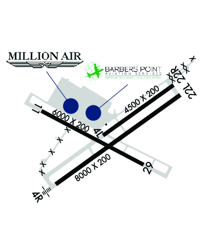
    Runway Identification: 04L/22R
    Length: 4500 ft
    Width: 200 ft
    Surface: ASPHALT-FAIR CONDITION
    Edge lights: Medium Intensity

    Treatment: NONE

     Runway: 04L   Runway: 22R
    Mag heading: 44°Mag heading: 224°
    Rwy Slope: .18% UpRwy Slope: -.18% Down
    Approach: Approach:
    Pattern: Left TrafficPattern: Left Traffic
    Markings: BASICMarkings: BASIC
    Marking Condition: FAIRMarking Condition: FAIR
    Arresting Dev: Arresting Dev:
    Lat & Long: N2118.4  W15804.3Lat. & Long.: N2118.8  W15803.7
    Elev: 21.0 ft. MSLElev: 29.0 ft. MSL
    TCH: 35 ft. AGLTCH: 33 ft. AGL
    Visual Glide Path: 3.00 degreesVisual Glide Path: 3.00 degrees
    Displaced Threshold: NoDisplaced Threshold: No
    Touchdown Zone: YESTouchdown Zone: YES
    Touchdown Elev.: 26.3 feetTouchdown Elev.: 29.0 feet
    Visual Glide Slope: 2-Light PAPI on LEFT side of RunwayVisual Glide Slope: 2-Light PAPI on LEFT side of Runway
    RVR Equipment: RVR Equipment:
    RVV Equipment: NORVV Equipment: NO
    Approach Lights: Approach Lights:
    REIL: NOREIL: NO
    Centerline Lights: NOCenterline Lights: NO
    Touchdown lights: NOTouchdown lights: NO
    Runway Category: Runway with a Visual ApproachRunway Category: Runway with a Visual Approach
    Declared Distances: Declared Distances:
    Runway Identification: 04R/22L
    Length: 8000 ft
    Width: 200 ft
    Surface: ASPHALT-FAIR CONDITION
    Edge lights: Medium Intensity

    Treatment: NONE

     Runway: 04R   Runway: 22L
    Mag heading: 44°Mag heading: 224°
    Rwy Slope: .20% UpRwy Slope: -.20% Down
    Approach: Approach:
    Pattern: Left TrafficPattern: Left Traffic
    Markings: PRECISION INSTRUMENTMarkings: BASIC
    Marking Condition: FAIRMarking Condition: FAIR
    Arresting Dev: Arresting Dev:
    Lat & Long: N2118.0  W15804.8Lat. & Long.: N2118.8  W15803.6
    Elev: 11.0 ft. MSLElev: 27.0 ft. MSL
    TCH: 55 ft. AGLTCH: 32 ft. AGL
    Visual Glide Path: 3.00 degreesVisual Glide Path: 3.00 degrees
    Displaced Threshold: NoDisplaced Threshold: No
    Touchdown Zone: YESTouchdown Zone: YES
    Touchdown Elev.: 17.0 feetTouchdown Elev.: 27.0 feet
    Visual Glide Slope: 4-Light PAPI on RIGHT side of RunwayVisual Glide Slope: 4-Light PAPI on LEFT side of Runway
    RVR Equipment: RVR Equipment:
    RVV Equipment: NORVV Equipment: NO
    Approach Lights: Approach Lights:
    REIL: NOREIL: NO
    Centerline Lights: NOCenterline Lights: NO
    Touchdown lights: NOTouchdown lights: NO
    Runway Category: Runway with a Non-precision Approach having visibility minimums greater than 3/4 mileRunway Category: Runway with a Visual Approach
    Declared Distances: Declared Distances:
    Runway Identification: 11/29
    Length: 6000 ft
    Width: 200 ft
    Surface: ASPHALT-FAIR CONDITION
    Edge lights: Medium Intensity

    Treatment: NONE

     Runway: 11   Runway: 29
    Mag heading: 107°Mag heading: 287°
    Rwy Slope: -.33% DownRwy Slope: .33% Up
    Approach: Approach:
    Pattern: Left Traffic; LARGE ACFT REQUESTING RWY 11 CAN EXPECT RIGHT TRAFFIC.Pattern: Left Traffic
    Markings: BASICMarkings: BASIC
    Marking Condition: FAIRMarking Condition: FAIR
    Arresting Dev: Arresting Dev:
    Lat & Long: N2118.6  W15804.9Lat. & Long.: N2118.2  W15804.0
    Elev: 30.0 ft. MSLElev: 10.0 ft. MSL
    TCH: 48 ft. AGLTCH: 52 ft. AGL
    Visual Glide Path: 3.00 degreesVisual Glide Path: 3.00 degrees
    Displaced Threshold: NoDisplaced Threshold: No
    Touchdown Zone: YESTouchdown Zone: YES
    Touchdown Elev.: 30.0 feetTouchdown Elev.: 20.0 feet
    Visual Glide Slope: 4-Light PAPI on LEFT side of RunwayVisual Glide Slope: 4-Light PAPI on LEFT side of Runway
    RVR Equipment: RVR Equipment:
    RVV Equipment: NORVV Equipment: NO
    Approach Lights: Approach Lights:
    REIL: NOREIL: NO
    Centerline Lights: NOCenterline Lights: NO
    Touchdown lights: NOTouchdown lights: NO
    Runway Category: Runway with a Visual ApproachRunway Category: Runway with a Visual Approach
    Declared Distances: Declared Distances:
    C:1/P: