
| ||||||||||||||||||||||||||||||||
| ||||||||||||||||||||||||||||||||
| ||||||||||||||||||||||||||||||||
| ||||||||||||||||||||||||||||||||
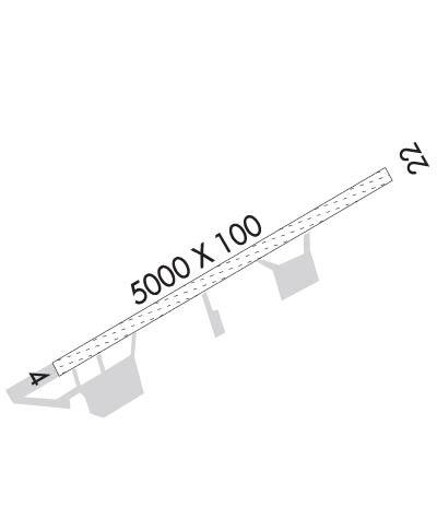
| Rwy | Rwy | |||||||
| 5000x100 | 5000' | 5000x100 | 5000' | |||||
| Runway ID | Single Wheel | Double Wheel | Double Tandem Wheel | Dual Double Wheel |
| 04/22 | N/A | N/A | N/A | N/A |
| These numbers are Advisory and are not limits. The Airport Manager should have more accurate Weight Limits | ||||
 Airport Diagram might not be current. | |
| Facility Name: | FORT YUKON |
| City Name: | FORT YUKON |
| County: | YUKON-KOYUKUK |
| State abbrev: | AK |
| State Name: | ALASKA |
| Ownership: | PUBLICLY OWNED |
| Use: | OPEN TO THE PUBLIC |
| Owner's Name: | ALASKA DOT&PF NORTHERN REGION |
| Address: | 2301 PEGER RD |
| FAIRBANKS, AK 99709 | |
| Owner's Phone: | 907-451-5280 |
| Manager's Name: | JASON LUDINGTON |
| Address: | 2301 PEGER RD |
| FAIRBANKS, AK 99709 | |
| Phone: | 907-451-5280 |
| FAA Region: | ALASKA |
| FAA Field Office: | NONE |
| Date | Sunrise | Sunset |
|---|---|---|
| 04/23/24 Tuesday | 5:21 | 21:59 |
| 04/24/24 Wednesday | 5:17 | 22:03 |
| 04/25/24 Thursday | 5:13 | 22:06 |
| 04/26/24 Friday | 5:09 | 22:10 |
| 04/27/24 Saturday | 5:05 | 22:14 |
| 04/28/24 Sunday | 5:01 | 22:18 |
| 04/29/24 Monday | 4:57 | 22:22 |
| 04/30/24 Tuesday | 4:53 | 22:26 |
| 05/01/24 Wednesday | 4:48 | 22:30 |
| 05/02/24 Thursday | 4:44 | 22:33 |
| 05/03/24 Friday | 4:40 | 22:37 |
| 05/04/24 Saturday | 4:36 | 22:41 |
| 05/05/24 Sunday | 4:32 | 22:45 |
| 05/06/24 Monday | 4:28 | 22:49 |
| Airport Attendance Schedule | UNATTENDED |
| Airport Status | OPERATIONAL (This Status can change at any time - please check NOTAMS) |
| Airport Lighting Schedule | ACTVT MALSF RWY 22; VASI RWY 04 & 22; MIRL RWY 04/22 - CTAF. |
| Airport Storage Available | NONE |
| Extra Services Available | Cargo Handling |
| Wind Indicator | YES - (lighted) |
| Control Tower | NO |
| CTAF Frequency | 122.500 |
| Unicom Frequency | |
| Rotating Beacon Color | WG |
| Segmented Circle | YES |
| Landing Fee | NO |
| Airport Inspected | STATE - performed by PRIVATE CONTRACT PERSONNEL |
| Inspection Date | 06/29/2021 |
| Type of Fuel Available | JET A (freeze point -40C); -A MAY - SEP - 907-622-2408. |
| Airframe Repair Service | None |
| Power Plant Repair Service | None |
| Latitude | N6634.3 |
| Longitude | W14514.8 (ESTIMATED) |
| Arpt Elevation | 447ft (SURVEYED) |
| Magnetic Variation | 20E |
| 0 miles N | of FORT YUKON |
| Traffic Pattern Altitude | |
| Sectional Chart | FAIRBANKS |
| Operations (Reported) | Yearly | Avg. Daily |
|---|---|---|
| General Aviation Transient | 600 | 2 |
| General Aviation Local | 2500 | 7 |
| Air Taxi | 5000 | 14 |
| Commerical | 0 | 0 |
| Commuter | 0 | 0 |
| Military | 250 | 1 |
| Aircraft based on Field | |
|---|---|
| General Aviation Singles | 0 |
| General Aviation Multi | 0 |
| Jet Aircraft | 0 |
| General Aviation Helicopters | 0 |
| Military Aircraft | 0 |
| Gliders | 0 |
| Ultralights | 0 |
| FSS on field | NO |
| FSS tie-in | FAIRBANKS |
| FSS Phone | 1-800-866-248-6516 |
| Who issues Notams | FYU |
| Notam D service at airport | YES |
| ARTCC Name | ANCHORAGE |
| Airport Certification | |
| Aircraft Rescue & Firefighting Index | None |
| Airport of Entry | No |
| Custom Landing Rights | No |
| Joint Civil/Military | No |
| Military Landing rights | YES |
| NATIONAL PLAN OF INTEGRATED AIRPORT SYSTEMS (NPIAS) |
| GRANT AGREEMENTS UNDER FAAP/ADAP/AIP |
| CONVEYANCE UNDER SCETION 16, FEDERAL AIRPORT ACT OF 1946 OR SECTION 23, AIRPORT AND AIRWAY DEVELOPMENT ACT OF 1970 |
| ASSURANCES PURSUANT TO TITLE VI, CIVIL RIGHTS ACT OF 1964 |
| FLOAT PLANE OPS DO NOT CROSS RWY 04/22. TFC PAT FOR HOSPITAL LAKE RMN NW OF ARPT. |
| WX CAMERA AVBL ON INTERNET AT HTTPS://WEATHERCAMS.FAA.GOV |
| TWY C REFLECTORS 36 IN; UNLGT; CLSD DURG WINTER. |
| LINE OF SIGHT BTN RWY THRS & WATERLANE NA; MON CTAF SPCLY BFR DEP. |
| SNOW REMOVAL OPS MNT CTAF. |
| RWY COND UNMNT; RCMD VISUAL INSP BFR LNDG. |
| SUAIS - 125.3/126.3/1-800-758-8723. |
| WX OBS CALLSIGN FORT YUKON WX - CTAF OR 907-662-2948 FM 0700-1900. |
| BIRDS INVOF LANDFILL 1/4 MI NW OF RWY. |
| RWY 04 DEP COMMENCE AT DTHR. |
Airport Communications & Frequencies:
| |||||||
| Runway: 04 | Runway: 22 | ||
| Mag heading: | 40° | Mag heading: | 220° |
| Rwy Slope: | .00% Down | Rwy Slope: | .00% Up |
| Approach: | Approach: | ||
| Pattern: | Left Traffic | Pattern: | Left Traffic |
| Markings: | Markings: | ||
| Marking Condition: | GOOD | Marking Condition: | GOOD |
| Arresting Dev: | Arresting Dev: | ||
| Lat & Long: | N6634.1 W14515.7 | Lat. & Long.: | N6634.5 W14513.9 |
| Elev: | 447.2 ft. MSL | Elev: | 447.1 ft. MSL |
| TCH: | 26 ft. AGL | TCH: | 27 ft. AGL |
| Visual Glide Path: | 3.00 degrees | Visual Glide Path: | 3.00 degrees |
| Displaced Threshold: | No | Displaced Threshold: | No |
| Touchdown Zone: | YES | Touchdown Zone: | YES |
| Touchdown Elev.: | 447.2 feet | Touchdown Elev.: | 447.2 feet |
| Visual Glide Slope: | 4-BOX VASI ON LEFT SIDE OF RUNWAY | Visual Glide Slope: | 4-BOX VASI ON LEFT SIDE OF RUNWAY |
| RVR Equipment: | RVR Equipment: | ||
| RVV Equipment: | NO | RVV Equipment: | NO |
| Approach Lights: | Approach Lights: | MALSF - 1,400 foot medium intensity approach lighting system with sequenced flashers | |
| REIL: | NO | REIL: | NO |
| Centerline Lights: | NO | Centerline Lights: | NO |
| Touchdown lights: | NO | Touchdown lights: | NO |
| Runway Category: | Runway with a Non-precision Approach | Runway Category: | Runway with a Non-precision Approach |
| Declared Distances: | Declared Distances: | ||
| Obstructions: | BRUSH | Obstructions: | BRUSH |
| Marked: | NOT Marked/Lighted | Marked: | NOT Marked/Lighted |
| Clearance slope: | Clearance slope: | ||
| Obstruction height: | 4 feet AGL | Obstruction height: | 2 feet AGL |
| Dist. from runway: | 0 feet | Dist. from runway: | 0 feet |
| Centerline offset: | 174 left of centerline | Centerline offset: | 225 feet left of centerline |
| Comments: | Comments: |
