
| ||||||||||||||||||||||||||||||||||||||||||||
| ||||||||||||||||||||||||||||||||||||||||||||
| ||||||||||||||||||||||||||||||||||||||||||||
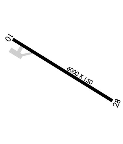
| Rwy | Rwy | |||||||
| 6000x150 | 6000' | 108.50 - 093° | 6000x150 | 6000' | ||||
| Runway ID | Single Wheel | Double Wheel | Double Tandem Wheel | Dual Double Wheel |
| 10/28 | 75,000 | 175,000 | 175,000 | N/A |
| These numbers are Advisory and are not limits. The Airport Manager should have more accurate Weight Limits | ||||
 Airport Diagram might not be current. | |
| Facility Name: | WRANGELL |
| City Name: | WRANGELL |
| County: | WRANGELL-PETERSBURG |
| State abbrev: | AK |
| State Name: | ALASKA |
| Ownership: | PUBLICLY OWNED |
| Use: | OPEN TO THE PUBLIC |
| Owner's Name: | ALASKA DOT&PF SOUTHCOAST REGION |
| Address: | 6860 GLACIER HWY |
| JUNEAU, AK 99801-7999 | |
| Owner's Phone: | 907-465-1786 |
| Manager's Name: | GARY ALLEN |
| Address: | BOX 1351 |
| WRANGELL, AK 99929 | |
| Phone: | 907-874-3107 |
| FAA Region: | ALASKA |
| FAA Field Office: | NONE |
| Date | Sunrise | Sunset |
|---|---|---|
| 04/25/24 Thursday | 5:15 | 20:20 |
| 04/26/24 Friday | 5:13 | 20:22 |
| 04/27/24 Saturday | 5:11 | 20:25 |
| 04/28/24 Sunday | 5:08 | 20:27 |
| 04/29/24 Monday | 5:06 | 20:29 |
| 04/30/24 Tuesday | 5:04 | 20:31 |
| 05/01/24 Wednesday | 5:01 | 20:33 |
| 05/02/24 Thursday | 4:59 | 20:35 |
| 05/03/24 Friday | 4:57 | 20:37 |
| 05/04/24 Saturday | 4:55 | 20:39 |
| 05/05/24 Sunday | 4:52 | 20:41 |
| 05/06/24 Monday | 4:50 | 20:43 |
| 05/07/24 Tuesday | 4:48 | 20:45 |
| 05/08/24 Wednesday | 4:46 | 20:47 |
| Airport Attendance Schedule | 7 Days A Week 0600-1700 |
| Airport Status | OPERATIONAL (This Status can change at any time - please check NOTAMS) |
| Airport Lighting Schedule | ACTVT REIL RWY 10 & 28; VASI RWY 10 & 28; HIRL RWY 10/28 - CTAF. |
| Airport Storage Available | Hanger |
| Extra Services Available | Cargo Handling |
| Wind Indicator | YES - (lighted) |
| Control Tower | NO |
| CTAF Frequency | 122.600 |
| Unicom Frequency | |
| Rotating Beacon Color | WG |
| Segmented Circle | YES |
| Landing Fee |
| Airport Inspected | FEDERAL - performed by FAA AIRPORTS FIELD PERSONNEL |
| Inspection Date | 10/26/2023 |
| Type of Fuel Available | Grade 100LL, JET A (freeze point -40C) |
| Airframe Repair Service | MINOR |
| Power Plant Repair Service | MINOR |
| Latitude | N5629.1 |
| Longitude | W13222.2 (ESTIMATED) |
| Arpt Elevation | 44ft (SURVEYED) |
| Magnetic Variation | 20E |
| 1 miles NE | of WRANGELL |
| Traffic Pattern Altitude | |
| Sectional Chart | JUNEAU |
| Operations (Reported) | Yearly | Avg. Daily |
|---|---|---|
| General Aviation Transient | 2500 | 7 |
| General Aviation Local | 1000 | 3 |
| Air Taxi | 6200 | 17 |
| Commerical | 725 | 2 |
| Commuter | 0 | 0 |
| Military | 0 | 0 |
| Aircraft based on Field | |
|---|---|
| General Aviation Singles | 9 |
| General Aviation Multi | 0 |
| Jet Aircraft | 0 |
| General Aviation Helicopters | 0 |
| Military Aircraft | 0 |
| Gliders | 0 |
| Ultralights | 0 |
| FSS on field | NO |
| FSS tie-in | SITKA |
| FSS Phone | 1-800-800-478-6300 |
| Nearby FSS | JUNEAU |
| Phone | 1-800-866-297-2236 |
| Who issues Notams | WRG |
| Notam D service at airport | YES |
| ARTCC Name | ANCHORAGE |
| Airport Certification | AIRPORT RECEIVING SCHEDULED AIR CARRIER SERVICE FROM CARRIERS CERTIFICATED BY THE CIVIL AERONAUTICS BOARD; ARFF SVC AVBL DURG SKED ACR OPS ONLY. |
| Aircraft Rescue & Firefighting Index | AIRPORT HAS A CERTIFICATE UNDER CFR PART 139 |
| Airport of Entry | YES |
| Custom Landing Rights | No |
| Joint Civil/Military | No |
| Military Landing rights | YES |
| NATIONAL PLAN OF INTEGRATED AIRPORT SYSTEMS (NPIAS) |
| GRANT AGREEMENTS UNDER FAAP/ADAP/AIP |
| ASSURANCES PURSUANT TO TITLE VI, CIVIL RIGHTS ACT OF 1964 |
| THIS AIRPORT HAS BEEN SURVEYED BY THE NATIONAL GEODETIC SURVEY. |
| PAEW ON RWY. RCMD VISUAL INSP BFR USE. CTC FSS FOR NOTAMS. |
| PAJA ON RWY, TWY & PRKG APRON NA. |
| LEVEL ISLAND WX CAMERAS AVBL ON INTERNET AT HTTPS://WEATHERCAMS.FAA.GOV |
| ARPT SAND LRGR GRADATION THAN FAA RCMDD/SEE AC150/5200-30. |
| CLSD TO OPS MORE THAN 30 PAX SEATS EXC PPR. 24 HR PPR CARGO OPS OVER 100K - AMGR. |
| TWY B UNDER 12500 LB MAX GROSS TKOF WEIGHT. |
| 24 HR PPR FOR SEAPLANE ACES GATE ENTRY DURG ATNDD HR. |
| COLD TEMPERATURE AIRPORT. ALTITUDE CORRECTION REQUIRED AT OR BELOW -5C. |
| SOLID WASTE PROCESSING 2000 FT SW OF RWY 10 THR. |
| WILDLIFE ON & INVOF ARPT. |
| FUEL AVBL - 907-874-3276. |
| SNOW REMOVAL, WILDLIFE CTL, COND RPRTG & MAINT SVC AVBL DURG DUTY HR; AFT HR OR REQ - AMGR. |
| HIGH TRRN IMT S OF RWY. |
| RWY 10 CALM WIND RWY. |
Airport Communications & Frequencies:
| |||||||
| Runway: 10 | Runway: 28 | ||
| Mag heading: | 101° | Mag heading: | 281° |
| Rwy Slope: | .28% Up | Rwy Slope: | -.28% Down |
| Approach: | LDA/DME | Approach: | |
| Pattern: | Left Traffic | Pattern: | Right Traffic |
| Markings: | PRECISION INSTRUMENT | Markings: | PRECISION INSTRUMENT |
| Marking Condition: | GOOD | Marking Condition: | GOOD |
| Arresting Dev: | Arresting Dev: | ||
| Lat & Long: | N5629.3 W13222.9 | Lat. & Long.: | N5628.8 W13221.4 |
| Elev: | 27.0 ft. MSL | Elev: | 44.0 ft. MSL |
| TCH: | 52 ft. AGL | TCH: | 52 ft. AGL |
| Visual Glide Path: | 3.00 degrees | Visual Glide Path: | 3.00 degrees |
| Displaced Threshold: | No | Displaced Threshold: | No |
| Touchdown Zone: | YES | Touchdown Zone: | YES |
| Touchdown Elev.: | 27.0 feet | Touchdown Elev.: | 44.0 feet |
| Visual Glide Slope: | 4-BOX VASI ON LEFT SIDE OF RUNWAY; VASI UNUSBL BYD 2.5 NM; DOES NOT PROVIDE OBSTN CLRNC BYD 2.5 NM. | Visual Glide Slope: | 4-BOX VASI ON LEFT SIDE OF RUNWAY |
| RVR Equipment: | RVR Equipment: | ||
| RVV Equipment: | NO | RVV Equipment: | NO |
| Approach Lights: | Approach Lights: | ||
| REIL: | YES | REIL: | YES |
| Centerline Lights: | NO | Centerline Lights: | NO |
| Touchdown lights: | NO | Touchdown lights: | NO |
| Runway Category: | Runway with a Non-precision Approach having visibility minimums greater than 3/4 mile | Runway Category: | Runway with a Visual Approach |
| Declared Distances: | Declared Distances: | ||
| Obstructions: | HILL | Obstructions: | |
| Marked: | NOT Marked/Lighted | Marked: | |
| Clearance slope: | 34:1 | Clearance slope: | 20:1 |
| Obstruction height: | 270 feet AGL | Obstruction height: | |
| Dist. from runway: | 700 feet | Dist. from runway: | |
| Centerline offset: | 1150 right of centerline | Centerline offset: | |
| Comments: | Comments: |