OPERATIONAL (This Status can change at any time - please check NOTAMS)
Airport Lighting Schedule
ACTVT VASI RWY 31; MIRL RWY 13/31 - CTAF.
Airport Storage Available
Tie Downs, Hanger
Extra Services Available
Charter
Wind Indicator
YES - (unlit)
Control Tower
NO
CTAF Frequency
122.900
Unicom Frequency
Rotating Beacon Color
WG
Segmented Circle
YES
Landing Fee
NO
Airport Inspection Data
Airport Inspected
STATE - performed by PRIVATE CONTRACT PERSONNEL
Inspection Date
09/28/2023
Airport Services
Type of Fuel Available
Grade 100LL, JET A (freeze point -40C)
Airframe Repair Service
None
Power Plant Repair Service
None
Geographic Data
Latitude
N6007.8
Longitude
W14925.0 (ESTIMATED)
Arpt Elevation
27ft (ESTIMATED)
Magnetic Variation
19E
2 miles NE
of SEWARD
Traffic Pattern Altitude
TPA FIXED WING 1000 FT AGL. RWYS 31 & 34 ARRIVALS MAINTAIN AT LEAST 800 FT AGL UNTIL TURNING FINAL. RWYS 13 & 16 DEPARTURES CLIMB STRAIGHT AHEAD TO AT LEAST 800 FT AGL BEFORE TURNING WESTBOUND.
Sectional Chart
SEWARD
Aircraft Data
Operations (Reported)
Yearly
Avg. Daily
General Aviation Transient
4000
11
General Aviation Local
2000
5
Air Taxi
4500
12
Commerical
0
0
Commuter
0
0
Military
10
0
Aircraft based on Field
General Aviation Singles
23
General Aviation Multi
0
Jet Aircraft
0
General Aviation Helicopters
0
Military Aircraft
0
Gliders
0
Ultralights
0
FAA Services
FSS on field
NO
FSS tie-in
KENAI
FSS Phone
1-800-866-864-1737
Who issues Notams
SWD
Notam D service at airport
YES
ARTCC Name
ANCHORAGE
Federal Status
Airport Certification
Aircraft Rescue & Firefighting Index
None
Airport of Entry
No
Custom Landing Rights
No
Joint Civil/Military
No
Military Landing rights
YES
Federal Agreements
NATIONAL PLAN OF INTEGRATED AIRPORT SYSTEMS (NPIAS)
GRANT AGREEMENTS UNDER FAAP/ADAP/AIP
CONVEYANCE UNDER SCETION 16, FEDERAL AIRPORT ACT OF 1946 OR SECTION 23, AIRPORT AND AIRWAY DEVELOPMENT ACT OF 1970
ASSURANCES PURSUANT TO TITLE VI, CIVIL RIGHTS ACT OF 1964
Remarks
WX CAMERA AVBL ON INTERNET AT HTTPS://WEATHERCAMS.FAA.GOV
BIRDS WI 10 NM SPRING-FALL.
FIXED WING OPS OVR 12500 LB NA.
COLD TEMPERATURE AIRPORT. ALTITUDE CORRECTION REQUIRED AT OR BELOW -4C.
RCMD VISUAL INSP PRIOR TO TKOFF OR LNDG; MNTND ON IREG BASIS.
HVY ACFT RSTRD TO N TWY & N 400 FT OF APRON.
RCMDD PROC IN EFCT 1 MAY-15 SEP TO AVOID SEASONAL USE HELI 1 NM SSW.
RWY 16/3 4 DURG WINTER 4 IN DIP 15 IN WIDE FM NORTH THR.
RWY 31 APCH SLOPE 0:1.
Airport Communications & Frequencies:
CTAF Frequency:
122.900
Remarks
APCH/DEP SVC PRVDD BY ANCHORAGE ARTCC ON FREQS. 119.7/269.0 (KENAI RCAG) .
COMMUNICATIONS PRVDD BY KENAI FSS ON FREQ 122.6 (SEWARD RCO).
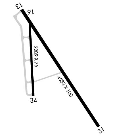
Length: 4249 ft Width: 100 ft Surface: ASPHALT-GOOD CONDITION Edge lights: Medium Intensity Treatment: NONE
Runway: 13
Runway: 31
Mag heading:
127°
Mag heading:
307°
Rwy Slope:
-.21% Down
Rwy Slope:
.21% Up
Approach:
Approach:
Pattern:
Left Traffic
Pattern:
Left Traffic
Markings:
BASIC
Markings:
BASIC
Marking Condition:
GOOD
Marking Condition:
GOOD
Arresting Dev:
Arresting Dev:
Lat & Long:
N6008.1 W14925.3
Lat. & Long.:
N6007.5 W14924.5
Elev:
27.7 ft. MSL
Elev:
18.7 ft. MSL
TCH:
TCH:
26 ft. AGL
Visual Glide Path:
Visual Glide Path:
3.00 degrees
Displaced Threshold:
No
Displaced Threshold:
No
Touchdown Zone:
YES
Touchdown Zone:
YES
Touchdown Elev.:
27.7 feet
Touchdown Elev.:
19.5 feet
Visual Glide Slope:
Visual Glide Slope:
4-BOX VASI ON LEFT SIDE OF RUNWAY; RWY 31 VASI UNUSBL BYD 5 DEG RIGHT OF CNTRLN; OFFSET 5 DEG CLKWS FM CNTRLN. RWY 31 VASI UNUSBL BYD 3 NM; OBSTN CLNC BYD 3 NM NA.
RVR Equipment:
RVR Equipment:
RVV Equipment:
NO
RVV Equipment:
NO
Approach Lights:
Approach Lights:
REIL:
NO
REIL:
NO
Centerline Lights:
NO
Centerline Lights:
NO
Touchdown lights:
NO
Touchdown lights:
NO
Runway Category:
Runway with a Visual Approach
Runway Category:
Runway with a Visual Approach
Declared Distances:
Declared Distances:
Obstructions:
BRDG
Obstructions:
BRUSH
Marked:
NOT Marked/Lighted
Marked:
NOT Marked/Lighted
Clearance slope:
CTLG OBSTN EXCEEDS 45 DEG SLOPE.
Clearance slope:
Obstruction height:
6 feet AGL
Obstruction height:
5 feet AGL
Dist. from runway:
200 feet
Dist. from runway:
202 feet
Centerline offset:
90 right of centerline
Centerline offset:
35 feet left of centerline
Comments:
Comments:
TREES & SHRUBS 100 FT FM RWY END BOTH SIDES.
Runway Identification: 16/34
Length: 2289 ft Width: 75 ft Surface: ASPHALT-GOOD CONDITION Edge lights: Treatment: NONE