
| ||||||||||||||||||||||||||||||||
| ||||||||||||||||||||||||||||||||
| ||||||||||||||||||||||||||||||||
| Rwy | Rwy | |||||||
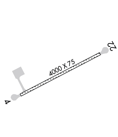
| 4000x75 | 4000' | 4000x75 | 4000' | |||||
| Runway ID | Single Wheel | Double Wheel | Double Tandem Wheel | Dual Double Wheel |
| 04/22 | N/A | N/A | N/A | N/A |
| These numbers are Advisory and are not limits. The Airport Manager should have more accurate Weight Limits | ||||
 Airport Diagram might not be current. | |
| Facility Name: | VENETIE |
| City Name: | VENETIE |
| County: | UPPER YUKON |
| State abbrev: | AK |
| State Name: | ALASKA |
| Ownership: | PRIVATELY OWNED |
| Use: | OPEN TO THE PUBLIC |
| Owner's Name: | VENETIE TRIBAL GOVERNMENT |
| Address: | BOX 81080 |
| VENETIE, AK 99781 | |
| Owner's Phone: | 907-849-8165 |
| Manager's Name: | EDDIE FRANK |
| Address: | PO BOX 81080 |
| VENETIE, AK 99781-0080 | |
| Phone: | 907-849-8165 |
| FAA Region: | ALASKA |
| FAA Field Office: | NONE |
| Date | Sunrise | Sunset |
|---|---|---|
| 04/25/24 Thursday | 5:14 | 22:15 |
| 04/26/24 Friday | 5:10 | 22:19 |
| 04/27/24 Saturday | 5:06 | 22:22 |
| 04/28/24 Sunday | 5:01 | 22:26 |
| 04/29/24 Monday | 4:57 | 22:30 |
| 04/30/24 Tuesday | 4:53 | 22:34 |
| 05/01/24 Wednesday | 4:48 | 22:39 |
| 05/02/24 Thursday | 4:44 | 22:43 |
| 05/03/24 Friday | 4:40 | 22:47 |
| 05/04/24 Saturday | 4:36 | 22:51 |
| 05/05/24 Sunday | 4:31 | 22:55 |
| 05/06/24 Monday | 4:27 | 22:59 |
| 05/07/24 Tuesday | 4:22 | 23:04 |
| 05/08/24 Wednesday | 4:18 | 23:08 |
| Airport Attendance Schedule | UNATTENDED |
| Airport Status | OPERATIONAL (This Status can change at any time - please check NOTAMS) |
| Airport Lighting Schedule | ACTVT MIRL RY 04/22 - CTAF.; ACTVT ROTG BCN - CTAF. |
| Airport Storage Available | NONE |
| Extra Services Available | Cargo Handling |
| Wind Indicator | YES - (lighted) |
| Control Tower | NO |
| CTAF Frequency | 122.900 |
| Unicom Frequency | |
| Rotating Beacon Color | WG |
| Segmented Circle | YES |
| Landing Fee | NO |
| Airport Inspected | 5010-2 PRIVATE USE MAILOUT PROGRAM - performed by PRIVATE CONTRACT PERSONNEL |
| Inspection Date | 07/06/2023 |
| Type of Fuel Available | None |
| Airframe Repair Service | NONE |
| Power Plant Repair Service | NONE |
| Latitude | N6700.5 |
| Longitude | W14622.0 (ESTIMATED) |
| Arpt Elevation | 574ft (SURVEYED) |
| Magnetic Variation | 18E |
| 1 miles E | of VENETIE |
| Traffic Pattern Altitude | |
| Sectional Chart | FAIRBANKS |
| Operations (Reported) | Yearly | Avg. Daily |
|---|---|---|
| General Aviation Transient | 400 | 1 |
| General Aviation Local | 0 | 0 |
| Air Taxi | 1500 | 4 |
| Commerical | 0 | 0 |
| Commuter | 0 | 0 |
| Military | 0 | 0 |
| Aircraft based on Field | |
|---|---|
| General Aviation Singles | 0 |
| General Aviation Multi | 0 |
| Jet Aircraft | 0 |
| General Aviation Helicopters | 0 |
| Military Aircraft | 0 |
| Gliders | 0 |
| Ultralights | 0 |
| FSS on field | NO |
| FSS tie-in | FAIRBANKS |
| FSS Phone | 1-800-866-248-6516 |
| Who issues Notams | FAI |
| Notam D service at airport | YES |
| ARTCC Name | ANCHORAGE |
| Airport Certification | |
| Aircraft Rescue & Firefighting Index | None |
| Airport of Entry | No |
| Custom Landing Rights | No |
| Joint Civil/Military | No |
| Military Landing rights | No |
| NATIONAL PLAN OF INTEGRATED AIRPORT SYSTEMS (NPIAS) |
| PPR BEFORE LNDG PHONE 907-849-8165. |
| MAINT IN WINTER VARIABLE. |
| CONSTRUCTION EQUIPMENT & PERSONS OPERATING ON & INVOF OF RY. |
| RY 04 ROAD TRANSITS RY APRX 300 FT FM THLD. |
| TAXIWAY LGTS OTS INDELFY. |
| ROTG BCN OTS INDEFLY. |
| RWY 04/2 2 RY 04/22 SFC SLIPPERY WHEN WET, SFC UNEVEN & SPARSELY GRVLD. |
Airport Communications & Frequencies:
| |||||||
| Runway: 04 | Runway: 22 | ||
| Mag heading: | 44° | Mag heading: | 224° |
| Rwy Slope: | .05% Up | Rwy Slope: | -.05% Down |
| Approach: | Approach: | ||
| Pattern: | Left Traffic | Pattern: | Left Traffic |
| Markings: | NONE | Markings: | NONE |
| Marking Condition: | GOOD | Marking Condition: | GOOD |
| Arresting Dev: | Arresting Dev: | ||
| Lat & Long: | N6700.4 W14622.7 | Lat. & Long.: | N6700.7 W14621.2 |
| Elev: | 571.3 ft. MSL | Elev: | 573.3 ft. MSL |
| TCH: | TCH: | ||
| Visual Glide Path: | Visual Glide Path: | ||
| Displaced Threshold: | No | Displaced Threshold: | No |
| Touchdown Zone: | YES | Touchdown Zone: | YES |
| Touchdown Elev.: | 572.2 feet | Touchdown Elev.: | 574.1 feet |
| Visual Glide Slope: | Visual Glide Slope: | ||
| RVR Equipment: | RVR Equipment: | ||
| RVV Equipment: | NO | RVV Equipment: | NO |
| Approach Lights: | Approach Lights: | ||
| REIL: | NO | REIL: | NO |
| Centerline Lights: | NO | Centerline Lights: | NO |
| Touchdown lights: | NO | Touchdown lights: | NO |
| Runway Category: | Runway with a Non-precision Approach | Runway Category: | Runway with a Non-precision Approach |
| Declared Distances: | Declared Distances: | ||
| Obstructions: | ROAD | Obstructions: | TREES |
| Marked: | NOT Marked/Lighted | Marked: | NOT Marked/Lighted |
| Clearance slope: | 20:1 | Clearance slope: | 22:1 |
| Obstruction height: | 15 feet AGL | Obstruction height: | 45 feet AGL |
| Dist. from runway: | 300 feet | Dist. from runway: | 1006 feet |
| Centerline offset: | Centerline offset: | 214 feet left of centerline | |
| Comments: | Comments: |
