
| ||||||||||||||||||||||||||||||||
| ||||||||||||||||||||||||||||||||
| ||||||||||||||||||||||||||||||||
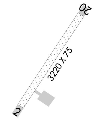
| Rwy | Rwy | |||||||
| 3220x75 | 3220' | 3220x75 | 3220' | |||||
| Runway ID | Single Wheel | Double Wheel | Double Tandem Wheel | Dual Double Wheel |
| 02/20 | N/A | N/A | N/A | N/A |
| These numbers are Advisory and are not limits. The Airport Manager should have more accurate Weight Limits | ||||
 Airport Diagram might not be current. | |
| Facility Name: | CHEVAK |
| City Name: | CHEVAK |
| County: | KUSILVAK |
| State abbrev: | AK |
| State Name: | ALASKA |
| Ownership: | PUBLICLY OWNED |
| Use: | OPEN TO THE PUBLIC |
| Owner's Name: | ALASKA DOT&PF CENTRAL REGION |
| Address: | PO BOX 196900 |
| ANCHORAGE, AK 99519-6900 | |
| Owner's Phone: | 907-269-0749 |
| Manager's Name: | JOSEPH LARAUX |
| Address: | 2016 AIRPORT ROAD |
| BETHEL, AK 99559 | |
| Phone: | (907) 543-2498; 907-543-2498 |
| FAA Region: | ALASKA |
| FAA Field Office: | NONE |
| Date | Sunrise | Sunset |
|---|---|---|
| 04/17/24 Wednesday | 7:31 | 22:34 |
| 04/18/24 Thursday | 7:28 | 22:37 |
| 04/19/24 Friday | 7:25 | 22:39 |
| 04/20/24 Saturday | 7:22 | 22:42 |
| 04/21/24 Sunday | 7:19 | 22:45 |
| 04/22/24 Monday | 7:16 | 22:47 |
| 04/23/24 Tuesday | 7:12 | 22:50 |
| 04/24/24 Wednesday | 7:09 | 22:53 |
| 04/25/24 Thursday | 7:06 | 22:55 |
| 04/26/24 Friday | 7:03 | 22:58 |
| 04/27/24 Saturday | 7:00 | 23:01 |
| 04/28/24 Sunday | 6:57 | 23:04 |
| 04/29/24 Monday | 6:54 | 23:06 |
| 04/30/24 Tuesday | 6:51 | 23:09 |
| Airport Attendance Schedule | UNATTENDED |
| Airport Status | OPERATIONAL (This Status can change at any time - please check NOTAMS) |
| Airport Lighting Schedule | ACTVT MIRL RY 02/20 - 122.8. ACTVT REIL & PAPI RYS 02 & 20 - CTAF.; ACTVT - CTAF |
| Airport Storage Available | NONE |
| Extra Services Available | NONE |
| Wind Indicator | YES - (lighted) |
| Control Tower | NO |
| CTAF Frequency | 123.000 |
| Unicom Frequency | 122.800 |
| Rotating Beacon Color | WG; NSTD WHITE FLASHING ROTG BCN. |
| Segmented Circle | YES |
| Landing Fee | NO |
| Airport Inspected | FEDERAL - performed by PRIVATE CONTRACT PERSONNEL |
| Inspection Date | 06/07/2023 |
| Type of Fuel Available | None |
| Airframe Repair Service | NONE |
| Power Plant Repair Service | NONE |
| Latitude | N6132.5 |
| Longitude | W16536.1 (ESTIMATED) |
| Arpt Elevation | 60ft () |
| Magnetic Variation | 09E |
| 1 miles N | of CHEVAK |
| Traffic Pattern Altitude | |
| Sectional Chart | BETHEL |
| Operations (Reported) | Yearly | Avg. Daily |
|---|---|---|
| General Aviation Transient | 0 | 0 |
| General Aviation Local | 0 | 0 |
| Air Taxi | 700 | 2 |
| Commerical | 0 | 0 |
| Commuter | 0 | 0 |
| Military | 0 | 0 |
| Aircraft based on Field | |
|---|---|
| General Aviation Singles | 0 |
| General Aviation Multi | 0 |
| Jet Aircraft | 0 |
| General Aviation Helicopters | 0 |
| Military Aircraft | 0 |
| Gliders | 0 |
| Ultralights | 0 |
| FSS on field | NO |
| FSS tie-in | KENAI |
| FSS Phone | 1-800-866-864-1737 |
| Who issues Notams | VAK |
| Notam D service at airport | YES |
| ARTCC Name | ANCHORAGE |
| Airport Certification | |
| Aircraft Rescue & Firefighting Index | None |
| Airport of Entry | No |
| Custom Landing Rights | No |
| Joint Civil/Military | No |
| Military Landing rights | YES |
| NATIONAL PLAN OF INTEGRATED AIRPORT SYSTEMS (NPIAS) |
| STRONG CROSS WIND AT THIS LCTN. |
| RY CONDITION NOT MONITORED; RECOMMEND VISUAL INSPECTION PRIOR TO USING. |
| WX CAMERAS AVBL ON INTERNET AT HTTPS://WEATHERCAMS.FAA.GOV |
| NUMEROUS BIRDS ON & INVOF ARPT. |
| RWY 02/2 0 RY USED AS ROAD. FIRST 200 FT OF RY02 ROUGH. |
Airport Communications & Frequencies:
| |||||||||
| Runway: 02 | Runway: 20 | ||
| Mag heading: | 24° | Mag heading: | 204° |
| Rwy Slope: | .36% Up | Rwy Slope: | -.36% Down |
| Approach: | Approach: | ||
| Pattern: | Left Traffic | Pattern: | Left Traffic |
| Markings: | Markings: | ||
| Marking Condition: | Marking Condition: | ||
| Arresting Dev: | Arresting Dev: | ||
| Lat & Long: | N6132.2 W16536.4 | Lat. & Long.: | N6132.7 W16535.8 |
| Elev: | 47.6 ft. MSL | Elev: | 59.3 ft. MSL |
| TCH: | 25 ft. AGL | TCH: | 25 ft. AGL |
| Visual Glide Path: | 3.00 degrees | Visual Glide Path: | 3.00 degrees |
| Displaced Threshold: | No | Displaced Threshold: | No |
| Touchdown Zone: | YES | Touchdown Zone: | YES |
| Touchdown Elev.: | 60.7 feet | Touchdown Elev.: | 60.7 feet |
| Visual Glide Slope: | 4-Light PAPI on LEFT side of Runway | Visual Glide Slope: | 4-Light PAPI on LEFT side of Runway |
| RVR Equipment: | RVR Equipment: | ||
| RVV Equipment: | NO | RVV Equipment: | NO |
| Approach Lights: | Approach Lights: | ||
| REIL: | YES | REIL: | YES |
| Centerline Lights: | NO | Centerline Lights: | NO |
| Touchdown lights: | NO | Touchdown lights: | NO |
| Runway Category: | Runway with a Non-precision Approach having visibility minimums greater than 3/4 mile | Runway Category: | Runway with a Non-precision Approach having visibility minimums greater than 3/4 mile |
| Declared Distances: | Declared Distances: |
