Click here for more info on on SMS!

PAUO

WILLOW AIRPORT
WILLOW
AK
Time Zone: Alaska
Lat: N 6145.3
Long: W 15003.1
Elev: 215
Var: -21
Longest Runway: 4400G
CTAF: 122.8

FBO & Flight Services info for PAUO

FBOs: Update your Fuel Prices

ACE CROWLEYPh: 907-777-5505
-
-
Service
Jet
100LL
SAF
MoGas
Fuel Avail: 24/7 self serve. Call to register MC/Visa for 0.15 cent/gallon discount
Full        Last Update: 04/05/2024 15:37

Self  6.80    
 Address: 2321 MERRILL FIELD DRIVE,   ANCHORAGE, AK
RUNWAY-GRAVEL
-
-
 
If you are an FBO, call 1-203-262-1700 to update your info or email: FltPlan.Advertising@garmin.com
Advertise your FBO on FltPlan.com

Runway & Approach Info for PAUO
Rwy
Length
Land Dist**
Approach*
  Rwy
Length
Land Dist**
Approach*
13
4400x75  4400'          
 
  
31
  4400x75  4000'          
 
 * only ILS, LOC, LDA, and SDF approaches to a specific runway are shown
** For any Declared Landing Distance Available, please see A/FD or Approach plates
Runway Weight Capability (lbs.) Help
Runway IDSingle WheelDouble WheelDouble Tandem WheelDual Double Wheel
13/31N/AN/AN/AN/A
These numbers are Advisory and are not limits.   The Airport Manager should have more accurate Weight Limits
Approach Charts
Approaches    
Current Weather/Notams
Customs Information Send updates to Support@FltPlan.com
Customs Not Available
Database effective 05/16/2024
Airport Diagram of PAUO
Airport Diagram might not be current.

Facility Name: WILLOW
City Name: WILLOW
County: MATANUSKA-SUSITNA
State abbrev: AK
State Name: ALASKA
   
Ownership: PUBLICLY OWNED
Use: OPEN TO THE PUBLIC
Owner's Name: ALASKA DOT&PF CENTRAL REGION
Address: PO BOX 196900
 ANCHORAGE, AK 99519-6900
Owner's Phone: 907-269-0770
  
Manager's Name: RAY ADAMS
Address: ST OF AK -- DOTPF WILLOW STATION, PO BOX 889
 WILLOW, AK 99688
Phone: 907-495-6286
   
FAA Region: ALASKA
FAA Field Office: NONE


Sunrise / Sunset times for WILLOW

DateSunriseSunset
04/22/24 Monday6:1221:46
04/23/24 Tuesday6:0921:49
04/24/24 Wednesday6:0621:52
04/25/24 Thursday6:0321:54
04/26/24 Friday6:0021:57
04/27/24 Saturday5:5722:00
04/28/24 Sunday5:5422:03
04/29/24 Monday5:5122:05
04/30/24 Tuesday5:4822:08
05/01/24 Wednesday5:4522:11
05/02/24 Thursday5:4222:13
05/03/24 Friday5:3922:16
05/04/24 Saturday5:3622:19
05/05/24 Sunday5:3322:22

Airport Facilities

Airport Attendance ScheduleUNATTENDED
Airport Status OPERATIONAL (This Status can change at any time - please check NOTAMS)
Airport Lighting ScheduleACTVT MIRL RWY 13/31 - CTAF.; ACVT ROTG BCN - CTAF.
Airport Storage AvailableTie Downs, Hanger
Extra Services AvailableCargo Handling, Charter, Flight Instruction
Wind IndicatorYES - (lighted)
Control TowerNO
CTAF Frequency122.800
Unicom Frequency
Rotating Beacon ColorWG
Segmented CircleYES
Landing FeeNO

Airport Inspection Data

Airport InspectedSTATE - performed by STATE AERONAUTICAL PERSONNEL
Inspection Date08/15/2020

Airport Services

Type of Fuel AvailableGrade 100LL; -10CREDIT CARD SELF SERVE FUEL AVBL 24 HRS.
Airframe Repair ServiceMAJOR
Power Plant Repair ServiceMAJOR

Geographic Data

LatitudeN6145.3
LongitudeW15003.1 (ESTIMATED)
Arpt Elevation215ft (SURVEYED)
Magnetic Variation21E
1 miles NWof WILLOW
Traffic Pattern Altitude
Sectional ChartANCHORAGE

Aircraft Data

Operations (Reported)YearlyAvg. Daily
General Aviation Transient 594616
General Aviation Local 467813
Air Taxi 494714
Commerical 00
Commuter 00
Military 2441
Aircraft based on Field
General Aviation Singles 68
General Aviation Multi 0
Jet Aircraft 0
General Aviation Helicopters 1
Military Aircraft 0
Gliders 0
Ultralights 0

FAA Services

FSS on field NO
FSS tie-in KENAI
FSS Phone 1-800-866-864-1737
Who issues Notams ENA
Notam D service at airport YES
ARTCC Name ANCHORAGE

Federal Status

Airport Certification
Aircraft Rescue & Firefighting IndexNone
Airport of EntryNo
Custom Landing RightsNo
Joint Civil/MilitaryNo
Military Landing rightsYES

Federal Agreements

NATIONAL PLAN OF INTEGRATED AIRPORT SYSTEMS (NPIAS)
SURPLUS PROPERTY AGREEMENT UNDER PUBLIC LAW 289

Remarks

RY COND NOT MONITORED; RCMD VISUAL INSPECTION PRIOR TO USING.
FLOAT PLANES ON WILLOW LAKE ACROSS ROAD.
WHEN AVBL WEA RPRTS HRLY ONLY.
WX CAMERA AVBL ON INTERNET AT HTTPS://WEATHERCAMS.FAA.GOV
Airport Communications & Frequencies:
CTAF Frequency:
122.800
Remarks
  • APCH/DEP SVC PRVDD BY ANCHORAGE ARTCC (BIG LAKE RCAG) ON FREQS 133.7/279.6.
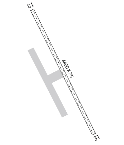
  • Runway Identifications
    Runway Identification: 13/31
    Length: 4400 ft
    Width: 75 ft
    Surface: GRAVEL-GOOD CONDITION
    Edge lights: Medium Intensity

    Treatment: NONE

     Runway: 13   Runway: 31
    Mag heading: 133°Mag heading: 313°
    Rwy Slope: .34% UpRwy Slope: -.34% Down
    Approach: Approach:
    Pattern: Left TrafficPattern: Right Traffic
    Markings: NONSTANDARDMarkings: NONSTANDARD
    Marking Condition: RY 13 NSTD MKGS; THLD MKD WITH FLEXIBLE REFLECTIVE MKRS & CONES.Marking Condition: RY 31 NSTD MKGS; DSPLCD THLD MARKED WITH REFLECTIVE FLEXIBLE MARKERS AND CONES. TWY MARKINGS THROUGH DSPLCD THLD.
    Arresting Dev: Arresting Dev:
    Lat & Long: N6145.6  W15003.4Lat. & Long.: N6144.9  W15002.8
    Elev: 200.3 ft. MSLElev: 215.3 ft. MSL
    TCH: TCH:
    Visual Glide Path: Visual Glide Path:
    Displaced Threshold: NoDisplaced Threshold: 400 feet
    Touchdown Zone: YESTouchdown Zone: YES
    Touchdown Elev.: 214.9 feetTouchdown Elev.: 213.2 feet
    Visual Glide Slope: Visual Glide Slope:
    RVR Equipment: RVR Equipment:
    RVV Equipment: NORVV Equipment: NO
    Approach Lights: Approach Lights:
    REIL: NOREIL: NO
    Centerline Lights: NOCenterline Lights: NO
    Touchdown lights: NOTouchdown lights: NO
    Runway Category: Runway with a Visual ApproachRunway Category: Runway with a Visual Approach
    Declared Distances: Declared Distances:
    Obstructions: TREESObstructions: TREES
    Marked: NOT Marked/LightedMarked: NOT Marked/Lighted
    Clearance slope: 7:1Clearance slope: 6:1; APCH SLOPE 20:1 TO DSPLCD THR.
    Obstruction height: 55 feet AGLObstruction height: 43 feet AGL
    Dist. from runway: 390 feetDist. from runway: 300 feet
    Centerline offset: 225 right of centerlineCenterline offset: 200 feet right of centerline
    Comments: Comments:
    C:/P: