Current Weather/Notams (Metars, TAFs, Notams, NWS Forecast, PIREPS, and nearby weather)
Customs Information Send updates to Support@FltPlan.com
Customs Not Available
Database effective 05/16/2024
Airport Diagram might not be current.
|
| Facility Name: | UNALAKLEET |
| City Name: | UNALAKLEET |
| County: | NOME |
| State abbrev: | AK |
| State Name: | ALASKA |
| | |
| Ownership: | PUBLICLY OWNED |
| Use: | OPEN TO THE PUBLIC |
| Owner's Name: | ALASKA DOT&PF NORTHERN REGION |
| Address: | NORTHERN REGION, 2301 PEGER RD |
| | FAIRBANKS, AK 99701 |
| Owner's Phone: | 907-451-2200 |
| | |
| Manager's Name: | JOHN WILSON |
| Address: | PO BOX 192 |
| | UNALAKLEET, AK 99684 |
| Phone: | 907-625-1025 |
| | |
| FAA Region: | ALASKA |
| FAA Field Office: | NONE |
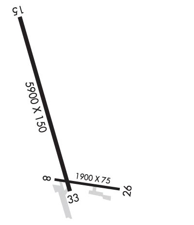
Runway Identifications
Runway Identification: 09/27Length: 1900 ft
Width: 75 ft
Surface: ASPHALT-GOOD CONDITION
Edge lights: Medium IntensityTreatment: GROOVED
Weight: PCN 59 /F/B/X/T
| | Runway: 09 | | Runway: 27 |
| Mag heading: | 87° | Mag heading: | 267° |
| Rwy Slope: | -.25% Down | Rwy Slope: | .25% Up |
| Approach: | | Approach: | |
| Pattern: | Left Traffic | Pattern: | Left Traffic |
| Markings: | BASIC | Markings: | BASIC |
| Marking Condition: | GOOD | Marking Condition: | GOOD |
| Arresting Dev: | | Arresting Dev: | |
| Lat & Long: | N6353.0 W16047.9 | Lat. & Long.: | N6353.0 W16047.2 |
| Elev: | 24.1 ft. MSL | Elev: | 19.3 ft. MSL |
| TCH: | | TCH: | |
| Visual Glide Path: | | Visual Glide Path: | |
| Displaced Threshold: | No | Displaced Threshold: | No |
| Touchdown Zone: | YES | Touchdown Zone: | YES |
| Touchdown Elev.: | 24.2 feet | Touchdown Elev.: | 24.2 feet |
| Visual Glide Slope: | | Visual Glide Slope: | |
| RVR Equipment: | | RVR Equipment: | |
| RVV Equipment: | NO | RVV Equipment: | NO |
| Approach Lights: | | Approach Lights: | |
| REIL: | NO | REIL: | NO |
| Centerline Lights: | NO | Centerline Lights: | NO |
| Touchdown lights: | NO | Touchdown lights: | NO |
| Runway Category: | Runway with a Visual Approach | Runway Category: | Runway with a Visual Approach |
| Declared Distances: | | Declared Distances: | |
| Obstructions: | | Obstructions: | BRDG |
| Marked: | | Marked: | NOT Marked/Lighted |
| Clearance slope: | 50:1 | Clearance slope: | 24:1 |
| Obstruction height: | | Obstruction height: | 20 feet AGL |
| Dist. from runway: | | Dist. from runway: | 690 feet |
| Centerline offset: | | Centerline offset: | 310 feet left of centerline |
| Comments: | | Comments: | |
Runway Identification: 15/33Length: 5900 ft
Width: 150 ft
Surface: ASPHALT-GOOD CONDITION
Edge lights: High IntensityTreatment: GROOVED
| | Runway: 15 | | Runway: 33 |
| Mag heading: | 153° | Mag heading: | 333° |
| Rwy Slope: | -.02% Down | Rwy Slope: | .02% Up |
| Approach: | LOC/DME | Approach: | |
| Pattern: | Right Traffic | Pattern: | Left Traffic |
| Markings: | PRECISION INSTRUMENT | Markings: | PRECISION INSTRUMENT |
| Marking Condition: | GOOD | Marking Condition: | GOOD |
| Arresting Dev: | | Arresting Dev: | |
| Lat & Long: | N6353.9 W16048.4 | Lat. & Long.: | N6352.9 W16047.8 |
| Elev: | 25.7 ft. MSL | Elev: | 24.7 ft. MSL |
| TCH: | 39 ft. AGL | TCH: | 48 ft. AGL |
| Visual Glide Path: | 3.00 degrees | Visual Glide Path: | 3.00 degrees |
| Displaced Threshold: | No | Displaced Threshold: | No |
| Touchdown Zone: | YES | Touchdown Zone: | YES |
| Touchdown Elev.: | 27.3 feet | Touchdown Elev.: | 25.0 feet |
| Visual Glide Slope: | 4-BOX VASI ON LEFT SIDE OF RUNWAY | Visual Glide Slope: | 4-BOX VASI ON LEFT SIDE OF RUNWAY |
| RVR Equipment: | | RVR Equipment: | |
| RVV Equipment: | NO | RVV Equipment: | NO |
| Approach Lights: | | Approach Lights: | |
| REIL: | YES | REIL: | YES |
| Centerline Lights: | NO | Centerline Lights: | NO |
| Touchdown lights: | NO | Touchdown lights: | NO |
| Runway Category: | Runway with a Non-precision Approach having visibility minimums greater than 3/4 mile | Runway Category: | Runway with a Visual Approach |
| Declared Distances: | | Declared Distances: | |
| Obstructions: | ROAD | Obstructions: | BLDG |
| Marked: | NOT Marked/Lighted | Marked: | NOT Marked/Lighted |
| Clearance slope: | | Clearance slope: | 26:1 |
| Obstruction height: | 15 feet AGL | Obstruction height: | 25 feet AGL |
| Dist. from runway: | 200 feet | Dist. from runway: | 850 feet |
| Centerline offset: | 110 left of centerline | Centerline offset: | 300 feet right of centerline |
| Comments: | | Comments: | |

