
| ||||||||||||||||||||||||||||||||||||||||||||
| ||||||||||||||||||||||||||||||||||||||||||||
| ||||||||||||||||||||||||||||||||||||||||||||
| ||||||||||||||||||||||||||||||||||||||||||||
| Rwy | Rwy | |||||||
| 3500x75 | 3500' | 3500x75 | 3500' | |||||
| Runway ID | Single Wheel | Double Wheel | Double Tandem Wheel | Dual Double Wheel |
| 01/19 | N/A | N/A | N/A | N/A |
| These numbers are Advisory and are not limits. The Airport Manager should have more accurate Weight Limits | ||||
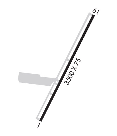 Airport Diagram might not be current. | |
| Facility Name: | TALKEETNA |
| City Name: | TALKEETNA |
| County: | MATANUSKA-SUSITNA |
| State abbrev: | AK |
| State Name: | ALASKA |
| Ownership: | PUBLICLY OWNED |
| Use: | OPEN TO THE PUBLIC |
| Owner's Name: | ALASKA DOT&PF CENTRAL REGION |
| Address: | P.O. BOX 196900 |
| ANCHORAGE, AK 99519-6900 | |
| Owner's Phone: | (907) 269-0760 |
| Manager's Name: | CHRIS DREWS |
| Address: | PO BOX 610 |
| TALKEETNA, AK 99676 | |
| Phone: | 907-733-2278 |
| FAA Region: | ALASKA |
| FAA Field Office: | NONE |
| Date | Sunrise | Sunset |
|---|---|---|
| 04/18/24 Thursday | 6:23 | 21:38 |
| 04/19/24 Friday | 6:20 | 21:41 |
| 04/20/24 Saturday | 6:16 | 21:43 |
| 04/21/24 Sunday | 6:13 | 21:46 |
| 04/22/24 Monday | 6:10 | 21:49 |
| 04/23/24 Tuesday | 6:07 | 21:52 |
| 04/24/24 Wednesday | 6:04 | 21:55 |
| 04/25/24 Thursday | 6:00 | 21:57 |
| 04/26/24 Friday | 5:57 | 22:00 |
| 04/27/24 Saturday | 5:54 | 22:03 |
| 04/28/24 Sunday | 5:51 | 22:06 |
| 04/29/24 Monday | 5:48 | 22:09 |
| 04/30/24 Tuesday | 5:45 | 22:12 |
| 05/01/24 Wednesday | 5:42 | 22:15 |
| Airport Attendance Schedule | APR-NOV MON-THU 1500-0130, DEC-MAR SUN-SAT 1500-0130 |
| Airport Status | OPERATIONAL (This Status can change at any time - please check NOTAMS) |
| Airport Lighting Schedule | ACTVT MIRL RY 01/19 - CTAF. VASI RYS 01 & 19 OPER CONT. |
| Airport Storage Available | Tie Downs |
| Extra Services Available | Cargo Handling, Charter |
| Wind Indicator | YES - (lighted) |
| Control Tower | NO |
| CTAF Frequency | 123.600 |
| Unicom Frequency | 123.000 |
| Rotating Beacon Color | WG |
| Segmented Circle | YES |
| Landing Fee | NO |
| Airport Inspected | FEDERAL - performed by PRIVATE CONTRACT PERSONNEL |
| Inspection Date | 09/13/2020 |
| Type of Fuel Available | Grade 100LL, JET A (freeze point -40C), JET A; -10FBO FUEL 24 HRS.; -A JET FUEL AVBL MON-FRI 1600-0200Z. JET A LCTD OFF ARPT. PRIOR ARRANGEMENTS FOR JET FUEL REQSTD TO AVOID DELAYS. 907-733-2620. AFT HRS FUEL ONLY AVBL WITH PRIOR ARRANGEMENTS. |
| Airframe Repair Service | MAJOR |
| Power Plant Repair Service | MAJOR |
| Latitude | N6219.3 |
| Longitude | W15005.6 (ESTIMATED) |
| Arpt Elevation | 365ft (SURVEYED) |
| Magnetic Variation | 16E |
| 1 miles E | of TALKEETNA |
| Traffic Pattern Altitude | |
| Sectional Chart | ANCHORAGE |
| Operations (Reported) | Yearly | Avg. Daily |
|---|---|---|
| General Aviation Transient | 16000 | 44 |
| General Aviation Local | 4000 | 11 |
| Air Taxi | 9500 | 26 |
| Commerical | 0 | 0 |
| Commuter | 0 | 0 |
| Military | 500 | 1 |
| Aircraft based on Field | |
|---|---|
| General Aviation Singles | 63 |
| General Aviation Multi | 1 |
| Jet Aircraft | 0 |
| General Aviation Helicopters | 2 |
| Military Aircraft | 0 |
| Gliders | 0 |
| Ultralights | 0 |
| FSS on field | YES |
| FSS tie-in | TALKEETNA |
| FSS Phone | 1-800-800-478-7150 |
| Nearby FSS | KENAI |
| Phone | 1-800-866-864-1737 |
| Who issues Notams | TKA |
| Notam D service at airport | YES |
| ARTCC Name | ANCHORAGE |
| Airport Certification | |
| Aircraft Rescue & Firefighting Index | None |
| Airport of Entry | No |
| Custom Landing Rights | No |
| Joint Civil/Military | No |
| Military Landing rights | YES |
| NATIONAL PLAN OF INTEGRATED AIRPORT SYSTEMS (NPIAS) |
| GRANT AGREEMENTS UNDER FAAP/ADAP/AIP |
| SURPLUS PROPERTY AGREEMENT UNDER PUBLIC LAW 289 |
| ASSURANCES PURSUANT TO TITLE VI, CIVIL RIGHTS ACT OF 1964 |
| HELO TFC USING FUEL/MAINT FAC REMAIN SOUTH OF FSS AND FLY DIRECT FROM ROTG BCN TO AVOID DAMAGE TO PARKED ACFT. |
| BE ALERT: CTAF PROCEDURES HIGHLY RECOMMENDED DUE TO VILLAGE TRAFFIC PATTERN. |
| SEE SECTION C: NOTICES, FOR TFC PATTERN INFO. |
| ARPT HAS DESIGNATED TRANSIENT ACFT PARKING AVBL. |
| BE ALERT: WALKING ON ACTIVE TAXIWAY/APRONS IS NOT AUTH. |
| WX CAMERA AVBL ON INTERNET AT HTTPS://WEATHERCAMS.FAA.GOV. |
| NEW HELICOPTER OPS AREA ON NORTH RAMP. |
| COLD TEMPERATURE AIRPORT. ALTITUDE CORRECTION REQUIRED AT OR BELOW -29C. |
| RWY 01/19 CLSD TO ACFT OVER 12500 LBS; CTC AMGR 907-733-2278. |
| RWY COND NOT MONTRD RCMD VISUAL INSPTN PRIOR TO USING. |
| SEAPLANE OPERATIONS 3/4 MILE SE TALKEETNA ARPT. RECOMMEND ACFT OPS TO & FROM CHRISTIANSEN LAKE REMAIN EAST OF LAKE. |
Airport Communications & Frequencies:
| |||||||||
| Runway: 01 | Runway: 19 | ||
| Mag heading: | 11° | Mag heading: | 191° |
| Rwy Slope: | .25% Up | Rwy Slope: | -.25% Down |
| Approach: | Approach: | ||
| Pattern: | Left Traffic | Pattern: | Right Traffic |
| Markings: | BASIC | Markings: | BASIC |
| Marking Condition: | GOOD | Marking Condition: | GOOD |
| Arresting Dev: | Arresting Dev: | ||
| Lat & Long: | N6219.0 W15005.8 | Lat. & Long.: | N6219.5 W15005.3 |
| Elev: | 356.1 ft. MSL | Elev: | 365.0 ft. MSL |
| TCH: | 23 ft. AGL | TCH: | 23 ft. AGL |
| Visual Glide Path: | 3.00 degrees | Visual Glide Path: | 3.00 degrees |
| Displaced Threshold: | No | Displaced Threshold: | No |
| Touchdown Zone: | YES | Touchdown Zone: | YES |
| Touchdown Elev.: | 363.2 feet | Touchdown Elev.: | 365.0 feet |
| Visual Glide Slope: | 4-BOX VASI ON RIGHT SIDE OF RUNWAY | Visual Glide Slope: | 4-BOX VASI ON LEFT SIDE OF RUNWAY |
| RVR Equipment: | RVR Equipment: | ||
| RVV Equipment: | NO | RVV Equipment: | NO |
| Approach Lights: | Approach Lights: | ||
| REIL: | NO | REIL: | NO |
| Centerline Lights: | NO | Centerline Lights: | NO |
| Touchdown lights: | NO | Touchdown lights: | NO |
| Runway Category: | Runway with a Visual Approach | Runway Category: | Runway with a Visual Approach |
| Declared Distances: | Declared Distances: | ||
| Obstructions: | TREES | Obstructions: | |
| Marked: | NOT Marked/Lighted | Marked: | |
| Clearance slope: | 4:1 | Clearance slope: | 20:1 |
| Obstruction height: | 47 feet AGL | Obstruction height: | |
| Dist. from runway: | 395 feet | Dist. from runway: | |
| Centerline offset: | 340 left of centerline | Centerline offset: | |
| Comments: | Comments: |