Current Weather/Notams (Metars, TAFs, Notams, NWS Forecast, PIREPS, and nearby weather)
Customs Information Send updates to Support@FltPlan.com
Customs Not Available
Database effective 04/18/2024
Airport Diagram might not be current.
|
| Facility Name: | TOGIAK |
| City Name: | TOGIAK VILLAGE |
| County: | DILLINGHAM |
| State abbrev: | AK |
| State Name: | ALASKA |
| | |
| Ownership: | PUBLICLY OWNED |
| Use: | OPEN TO THE PUBLIC |
| Owner's Name: | ALASKA DOT&PF CENTRAL REGION |
| Address: | PO BOX 196900 |
| | ANCHORAGE, AK 99519-6900 |
| Owner's Phone: | 907-269-0749 |
| | |
| Manager's Name: | JON TAYLOR |
| Address: | BOX 214 |
| | DILLINGHAM, AK 99576 |
| Phone: | 907-842-5511 |
| | |
| FAA Region: | ALASKA |
| FAA Field Office: | NONE |
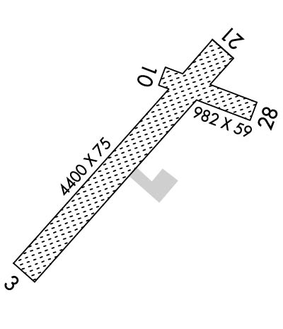
Runway Identifications
Runway Identification: 03/21Length: 4400 ft
Width: 100 ft
Surface: NATURAL SOIL-GOOD CONDITION
Edge lights: Medium IntensityTreatment: NONE
| | Runway: 03 | | Runway: 21 |
| Mag heading: | 31° | Mag heading: | 211° |
| Rwy Slope: | -.01% Down | Rwy Slope: | .01% Up |
| Approach: | | Approach: | |
| Pattern: | Left Traffic | Pattern: | Left Traffic |
| Markings: | NONE | Markings: | NONE |
| Marking Condition: | GOOD | Marking Condition: | GOOD |
| Arresting Dev: | | Arresting Dev: | |
| Lat & Long: | N5902.9 W16024.3 | Lat. & Long.: | N5903.4 W16023.4 |
| Elev: | 18.6 ft. MSL | Elev: | 18.3 ft. MSL |
| TCH: | 25 ft. AGL | TCH: | 31 ft. AGL |
| Visual Glide Path: | 3.00 degrees | Visual Glide Path: | 3.00 degrees |
| Displaced Threshold: | No | Displaced Threshold: | No |
| Touchdown Zone: | YES | Touchdown Zone: | YES |
| Touchdown Elev.: | 18.6 feet | Touchdown Elev.: | 18.3 feet |
| Visual Glide Slope: | 4-Light PAPI on LEFT side of Runway | Visual Glide Slope: | 4-Light PAPI on LEFT side of Runway |
| RVR Equipment: | | RVR Equipment: | |
| RVV Equipment: | NO | RVV Equipment: | NO |
| Approach Lights: | | Approach Lights: | |
| REIL: | NO | REIL: | NO |
| Centerline Lights: | NO | Centerline Lights: | NO |
| Touchdown lights: | NO | Touchdown lights: | NO |
| Runway Category: | Runway with a Non-precision Approach | Runway Category: | Runway with a Non-precision Approach |
| Declared Distances: | | Declared Distances: | |
| Obstructions: | ROAD; +15 | Obstructions: | Unknown |
| Marked: | NOT Marked/Lighted | Marked: | NOT Marked/Lighted |
| Clearance slope: | 4:1; CONTROLLING OBSTRUCTION | Clearance slope: | 34:1 |
| Obstruction height: | 15 feet AGL | Obstruction height: | 3 feet AGL |
| Dist. from runway: | 59 feet | Dist. from runway: | |
| Centerline offset: | 240 right of centerline | Centerline offset: | 130 feet right of centerline |
| Comments: | | Comments: | |
Runway Identification: 10/28Length: 982 ft
Width: 59 ft
Surface: -FAIR CONDITION
Edge lights: Treatment: NONE
| | Runway: 10 | | Runway: 28 |
| Mag heading: | 101° | Mag heading: | 281° |
| Rwy Slope: | .06% Up | Rwy Slope: | -.06% Down |
| Approach: | | Approach: | |
| Pattern: | Left Traffic | Pattern: | Left Traffic |
| Markings: | NONSTANDARD | Markings: | NONSTANDARD |
| Marking Condition: | FAIR | Marking Condition: | FAIR |
| Arresting Dev: | | Arresting Dev: | |
| Lat & Long: | N5903.4 W16023.6 | Lat. & Long.: | N5903.3 W16023.3 |
| Elev: | 16.1 ft. MSL | Elev: | 16.7 ft. MSL |
| TCH: | | TCH: | |
| Visual Glide Path: | | Visual Glide Path: | |
| Displaced Threshold: | No | Displaced Threshold: | No |
| Touchdown Zone: | YES | Touchdown Zone: | YES |
| Touchdown Elev.: | 17.8 feet | Touchdown Elev.: | 17.8 feet |
| Visual Glide Slope: | | Visual Glide Slope: | |
| RVR Equipment: | | RVR Equipment: | |
| RVV Equipment: | NO | RVV Equipment: | NO |
| Approach Lights: | | Approach Lights: | |
| REIL: | NO | REIL: | NO |
| Centerline Lights: | NO | Centerline Lights: | NO |
| Touchdown lights: | NO | Touchdown lights: | NO |
| Runway Category: | Runway with a Visual Approach | Runway Category: | Runway with a Visual Approach |
| Declared Distances: | | Declared Distances: | |
| Obstructions: | | Obstructions: | BLDG |
| Marked: | | Marked: | NOT Marked/Lighted |
| Clearance slope: | 20:1 | Clearance slope: | 11:1 |
| Obstruction height: | | Obstruction height: | 41 feet AGL |
| Dist. from runway: | | Dist. from runway: | 270 feet |
| Centerline offset: | | Centerline offset: | 163 feet left of centerline |
| Comments: | | Comments: | |

