Current Weather/Notams (Metars, TAFs, Notams, NWS Forecast, PIREPS, and nearby weather)
Customs Information Send updates to Support@FltPlan.com
Customs Not Available
Database effective 05/16/2024
Airport Diagram might not be current.
|
| Facility Name: | ST MARY'S |
| City Name: | ST MARY'S |
| County: | KUSILVAK |
| State abbrev: | AK |
| State Name: | ALASKA |
| | |
| Ownership: | PUBLICLY OWNED |
| Use: | OPEN TO THE PUBLIC |
| Owner's Name: | ALASKA DOT&PF NORTHERN REGION |
| Address: | 2301 PEGER ROAD |
| | FAIRBANKS, AK 99709 |
| Owner's Phone: | 907-443-3411 |
| | |
| Manager's Name: | ERIK WEINGARTH |
| Address: | PO BOX 135 |
| | ST MARY'S, AK 99658 |
| Phone: | 907-438-2416 |
| | |
| FAA Region: | ALASKA |
| FAA Field Office: | NONE |
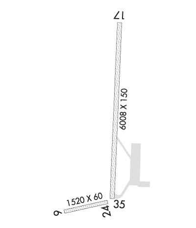
Runway Identifications
Runway Identification: 06/24Length: 1520 ft
Width: 60 ft
Surface: GRAVEL-GOOD CONDITION
Edge lights: Medium IntensityTreatment: NONE
| | Runway: 06 | | Runway: 24 |
| Mag heading: | 65° | Mag heading: | 245° |
| Rwy Slope: | -.36% Down | Rwy Slope: | .36% Up |
| Approach: | | Approach: | |
| Pattern: | Left Traffic | Pattern: | Left Traffic |
| Markings: | NONE | Markings: | NONE |
| Marking Condition: | GOOD | Marking Condition: | GOOD |
| Arresting Dev: | | Arresting Dev: | |
| Lat & Long: | N6203.2 W16318.7 | Lat. & Long.: | N6203.2 W16318.1 |
| Elev: | 314.1 ft. MSL | Elev: | 308.7 ft. MSL |
| TCH: | | TCH: | |
| Visual Glide Path: | | Visual Glide Path: | |
| Displaced Threshold: | No | Displaced Threshold: | No |
| Touchdown Zone: | YES | Touchdown Zone: | YES |
| Touchdown Elev.: | 314.1 feet | Touchdown Elev.: | 314.1 feet |
| Visual Glide Slope: | | Visual Glide Slope: | |
| RVR Equipment: | | RVR Equipment: | |
| RVV Equipment: | NO | RVV Equipment: | NO |
| Approach Lights: | | Approach Lights: | |
| REIL: | NO | REIL: | NO |
| Centerline Lights: | NO | Centerline Lights: | NO |
| Touchdown lights: | NO | Touchdown lights: | NO |
| Runway Category: | Runway with a Visual Approach | Runway Category: | Runway with a Visual Approach |
| Declared Distances: | | Declared Distances: | |
| Obstructions: | HILL | Obstructions: | HILL |
| Marked: | NOT Marked/Lighted | Marked: | NOT Marked/Lighted |
| Clearance slope: | 24:1 | Clearance slope: | 50:1 |
| Obstruction height: | 145 feet AGL | Obstruction height: | 100 feet AGL |
| Dist. from runway: | 3480 feet | Dist. from runway: | 5000 feet |
| Centerline offset: | | Centerline offset: | |
| Comments: | | Comments: | |
Runway Identification: 17/35Length: 6008 ft
Width: 150 ft
Surface: GRAVEL-GOOD CONDITION
Edge lights: High IntensityTreatment: NONE
| | Runway: 17 | | Runway: 35 |
| Mag heading: | 170° | Mag heading: | 350° |
| Rwy Slope: | .35% Up | Rwy Slope: | -.35% Down |
| Approach: | LOC/DME | Approach: | |
| Pattern: | Left Traffic | Pattern: | Left Traffic |
| Markings: | NONE | Markings: | NONE |
| Marking Condition: | FAIR | Marking Condition: | FAIR |
| Arresting Dev: | | Arresting Dev: | |
| Lat & Long: | N6204.3 W16318.0 | Lat. & Long.: | N6203.3 W16318.1 |
| Elev: | 290.3 ft. MSL | Elev: | 311.3 ft. MSL |
| TCH: | 51 ft. AGL | TCH: | 37 ft. AGL |
| Visual Glide Path: | 3.00 degrees | Visual Glide Path: | 3.00 degrees |
| Displaced Threshold: | No | Displaced Threshold: | No |
| Touchdown Zone: | YES | Touchdown Zone: | YES |
| Touchdown Elev.: | 304.6 feet | Touchdown Elev.: | 311.3 feet |
| Visual Glide Slope: | 4-BOX VASI ON LEFT SIDE OF RUNWAY | Visual Glide Slope: | 4-BOX VASI ON LEFT SIDE OF RUNWAY |
| RVR Equipment: | | RVR Equipment: | |
| RVV Equipment: | NO | RVV Equipment: | NO |
| Approach Lights: | MALSR - 1,400 foot medium intensity approach lighting system with runway alignment indicator lights; MALSR RY 17 OUT OF SERVICE INDEFINITELY. | Approach Lights: | |
| REIL: | NO | REIL: | YES |
| Centerline Lights: | NO | Centerline Lights: | NO |
| Touchdown lights: | NO | Touchdown lights: | NO |
| Runway Category: | Precision Instrument Runway | Runway Category: | Runway with a Non-precision Approach having visibility minimums greater than 3/4 mile |
| Declared Distances: | | Declared Distances: | |

