
| ||||||||||||||||||||||||||||||||
| ||||||||||||||||||||||||||||||||
| ||||||||||||||||||||||||||||||||
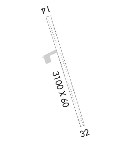
| Rwy | Rwy | |||||||
| 3100x60 | 3100' | 3100x60 | 3100' | |||||
| Runway ID | Single Wheel | Double Wheel | Double Tandem Wheel | Dual Double Wheel |
| 15/33 | N/A | N/A | N/A | N/A |
| These numbers are Advisory and are not limits. The Airport Manager should have more accurate Weight Limits | ||||
 Airport Diagram might not be current. | |
| Facility Name: | SLEETMUTE |
| City Name: | SLEETMUTE |
| County: | BETHEL |
| State abbrev: | AK |
| State Name: | ALASKA |
| Ownership: | PUBLICLY OWNED |
| Use: | OPEN TO THE PUBLIC |
| Owner's Name: | ALASKA DOT&PF CENTRAL REGION |
| Address: | PO BOX 196900 |
| ANCHORAGE, AK 99519-6900 | |
| Owner's Phone: | 907-269-0749 |
| Manager's Name: | ROXANNE EVAN |
| Address: | P.O. BOX 73 |
| ANIAK, AK 99557-7300 | |
| Phone: | 907-675-4345 |
| FAA Region: | ALASKA |
| FAA Field Office: | NONE |
| Date | Sunrise | Sunset |
|---|---|---|
| 04/25/24 Thursday | 6:32 | 22:23 |
| 04/26/24 Friday | 6:29 | 22:25 |
| 04/27/24 Saturday | 6:26 | 22:28 |
| 04/28/24 Sunday | 6:23 | 22:31 |
| 04/29/24 Monday | 6:20 | 22:33 |
| 04/30/24 Tuesday | 6:17 | 22:36 |
| 05/01/24 Wednesday | 6:14 | 22:39 |
| 05/02/24 Thursday | 6:11 | 22:42 |
| 05/03/24 Friday | 6:08 | 22:44 |
| 05/04/24 Saturday | 6:05 | 22:47 |
| 05/05/24 Sunday | 6:02 | 22:50 |
| 05/06/24 Monday | 5:59 | 22:53 |
| 05/07/24 Tuesday | 5:56 | 22:55 |
| 05/08/24 Wednesday | 5:54 | 22:58 |
| Airport Attendance Schedule | UNATTENDED |
| Airport Status | OPERATIONAL (This Status can change at any time - please check NOTAMS) |
| Airport Lighting Schedule | ACTVT MIRL RWY 15/33 - CTAF. |
| Airport Storage Available | NONE |
| Extra Services Available | NONE |
| Wind Indicator | YES - (unlit) |
| Control Tower | NO |
| CTAF Frequency | 122.800 |
| Unicom Frequency | 122.800 |
| Rotating Beacon Color | WG |
| Segmented Circle | NO |
| Landing Fee | NO |
| Airport Inspected | FEDERAL - performed by PRIVATE CONTRACT PERSONNEL |
| Inspection Date | 08/02/2023 |
| Type of Fuel Available | Grade 100LL; -10FUEL AVBL - CTAF OR (907) 449-4227. |
| Airframe Repair Service | NONE |
| Power Plant Repair Service | NONE |
| Latitude | N6142.0 |
| Longitude | W15710.0 (ESTIMATED) |
| Arpt Elevation | 191ft (SURVEYED) |
| Magnetic Variation | 13E |
| 0 miles E | of SLEETMUTE |
| Traffic Pattern Altitude | |
| Sectional Chart | MC GRATH |
| Operations (Reported) | Yearly | Avg. Daily |
|---|---|---|
| General Aviation Transient | 0 | 0 |
| General Aviation Local | 0 | 0 |
| Air Taxi | 500 | 1 |
| Commerical | 0 | 0 |
| Commuter | 0 | 0 |
| Military | 0 | 0 |
| Aircraft based on Field | |
|---|---|
| General Aviation Singles | 0 |
| General Aviation Multi | 0 |
| Jet Aircraft | 0 |
| General Aviation Helicopters | 0 |
| Military Aircraft | 0 |
| Gliders | 0 |
| Ultralights | 0 |
| FSS on field | NO |
| FSS tie-in | KENAI |
| FSS Phone | 1-800-866-864-1737 |
| Who issues Notams | SLQ |
| Notam D service at airport | YES |
| ARTCC Name | ANCHORAGE |
| Airport Certification | |
| Aircraft Rescue & Firefighting Index | None |
| Airport of Entry | No |
| Custom Landing Rights | No |
| Joint Civil/Military | No |
| Military Landing rights | YES |
| NATIONAL PLAN OF INTEGRATED AIRPORT SYSTEMS (NPIAS) |
| RWY CONDITION NOT MONITORED; RECOMMEND VISUAL INSPECTION PRIOR TO USING. |
| ATVS NEAR OR ON RWY. |
| RED DEVIL ARPT 8 MILES NW. |
| WX CAMERA AVBL ON INTERNET AT HTTPS://WEATHERCAMS.FAA.GOV. |
| RWY 15/33 N 500 FT SOFT |
| COLD TEMPERATURE AIRPORT. ALTITUDE CORRECTION REQUIRED AT OR BELOW -37C. |
| RWY 15/3 3 RWY 15/33 SOFT SPOTS ON RWY WHEN WET. |
Airport Communications & Frequencies:
| |||||||||
| Runway: 15 | Runway: 33 | ||
| Mag heading: | 153° | Mag heading: | 333° |
| Rwy Slope: | .01% Up | Rwy Slope: | -.01% Down |
| Approach: | Approach: | ||
| Pattern: | Left Traffic | Pattern: | Left Traffic |
| Markings: | NONE | Markings: | NONE |
| Marking Condition: | FAIR; RWY END MARKED WITH LGTS. | Marking Condition: | FAIR; RWY END MARKED WITH LGTS. |
| Arresting Dev: | Arresting Dev: | ||
| Lat & Long: | N6142.3 W15710.1 | Lat. & Long.: | N6141.8 W15709.8 |
| Elev: | 190.9 ft. MSL | Elev: | 191.3 ft. MSL |
| TCH: | TCH: | ||
| Visual Glide Path: | Visual Glide Path: | ||
| Displaced Threshold: | No | Displaced Threshold: | No |
| Touchdown Zone: | YES | Touchdown Zone: | YES |
| Touchdown Elev.: | 191.6 feet | Touchdown Elev.: | 191.6 feet |
| Visual Glide Slope: | Visual Glide Slope: | ||
| RVR Equipment: | RVR Equipment: | ||
| RVV Equipment: | NO | RVV Equipment: | NO |
| Approach Lights: | Approach Lights: | ||
| REIL: | NO | REIL: | NO |
| Centerline Lights: | NO | Centerline Lights: | NO |
| Touchdown lights: | NO | Touchdown lights: | NO |
| Runway Category: | Runway with a Visual Approach | Runway Category: | Runway with a Non-precision Approach |
| Declared Distances: | Declared Distances: | ||
| Obstructions: | BRUSH | Obstructions: | TREE |
| Marked: | NOT Marked/Lighted | Marked: | NOT Marked/Lighted |
| Clearance slope: | Clearance slope: | ||
| Obstruction height: | 12 feet AGL | Obstruction height: | 28 feet AGL |
| Dist. from runway: | 0 feet | Dist. from runway: | 0 feet |
| Centerline offset: | 110B | Centerline offset: | 120B |
| Comments: | Comments: |
