
| ||||||||||||||||||||||||||||||||
| ||||||||||||||||||||||||||||||||
| ||||||||||||||||||||||||||||||||
| ||||||||||||||||||||||||||||||||
| Rwy | Rwy | |||||||
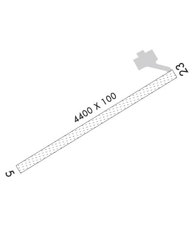
| 4400x100 | 4400' | 4400x100 | 4400' | |||||
| Runway ID | Single Wheel | Double Wheel | Double Tandem Wheel | Dual Double Wheel |
| 05/23 | N/A | N/A | N/A | N/A |
| These numbers are Advisory and are not limits. The Airport Manager should have more accurate Weight Limits | ||||
 Airport Diagram might not be current. | |
| Facility Name: | SAVOONGA |
| City Name: | SAVOONGA |
| County: | NOME |
| State abbrev: | AK |
| State Name: | ALASKA |
| Ownership: | PUBLICLY OWNED |
| Use: | OPEN TO THE PUBLIC |
| Owner's Name: | ALASKA DOT&PF NORTHERN REGION |
| Address: | 2301 PEGER RD |
| FAIRBANKS, AK 99709 | |
| Owner's Phone: | 907-451-2200 |
| Manager's Name: | GEORGE KOST |
| Address: | PO BOX 1048 |
| NOME, AK 99762 | |
| Phone: | 907-443-2500 |
| FAA Region: | ALASKA |
| FAA Field Office: | NONE |
| Date | Sunrise | Sunset |
|---|---|---|
| 04/25/24 Thursday | 5:14 | 21:27 |
| 04/26/24 Friday | 5:11 | 21:30 |
| 04/27/24 Saturday | 5:07 | 21:33 |
| 04/28/24 Sunday | 5:04 | 21:36 |
| 04/29/24 Monday | 5:00 | 21:40 |
| 04/30/24 Tuesday | 4:57 | 21:43 |
| 05/01/24 Wednesday | 4:54 | 21:46 |
| 05/02/24 Thursday | 4:50 | 21:49 |
| 05/03/24 Friday | 4:47 | 21:52 |
| 05/04/24 Saturday | 4:44 | 21:55 |
| 05/05/24 Sunday | 4:40 | 21:58 |
| 05/06/24 Monday | 4:37 | 22:01 |
| 05/07/24 Tuesday | 4:34 | 22:05 |
| 05/08/24 Wednesday | 4:31 | 22:08 |
| Airport Attendance Schedule | UNATTENDED |
| Airport Status | OPERATIONAL (This Status can change at any time - please check NOTAMS) |
| Airport Lighting Schedule | ACTVT MIRL RY 05/23 - CTAF. VASI RYS 05 & 23 OPER CONTINUOUSLY . |
| Airport Storage Available | NONE |
| Extra Services Available | NONE |
| Wind Indicator | YES - (lighted) |
| Control Tower | NO |
| CTAF Frequency | 122.700 |
| Unicom Frequency | |
| Rotating Beacon Color | WG |
| Segmented Circle | YES |
| Landing Fee | NO |
| Airport Inspected | STATE - performed by PRIVATE CONTRACT PERSONNEL |
| Inspection Date | 08/29/2023 |
| Type of Fuel Available | None |
| Airframe Repair Service | NONE |
| Power Plant Repair Service | NONE |
| Latitude | N6341.2 |
| Longitude | W17029.6 (ESTIMATED) |
| Arpt Elevation | 59ft (SURVEYED) |
| Magnetic Variation | 10E |
| 1 miles SW | of SAVOONGA |
| Traffic Pattern Altitude | |
| Sectional Chart | BETHEL |
| Operations (Reported) | Yearly | Avg. Daily |
|---|---|---|
| General Aviation Transient | 0 | 0 |
| General Aviation Local | 0 | 0 |
| Air Taxi | 0 | 0 |
| Commerical | 256 | 1 |
| Commuter | 0 | 0 |
| Military | 4 | 0 |
| Aircraft based on Field | |
|---|---|
| General Aviation Singles | 0 |
| General Aviation Multi | 0 |
| Jet Aircraft | 0 |
| General Aviation Helicopters | 0 |
| Military Aircraft | 0 |
| Gliders | 0 |
| Ultralights | 0 |
| FSS on field | NO |
| FSS tie-in | NOME |
| FSS Phone | 1-800-800-478-8400 |
| Nearby FSS | FAIRBANKS |
| Phone | 1-800-866-248-6516 |
| Who issues Notams | SVA |
| Notam D service at airport | YES |
| ARTCC Name | ANCHORAGE |
| Airport Certification | |
| Aircraft Rescue & Firefighting Index | None |
| Airport of Entry | No |
| Custom Landing Rights | No |
| Joint Civil/Military | No |
| Military Landing rights | YES |
| NATIONAL PLAN OF INTEGRATED AIRPORT SYSTEMS (NPIAS) |
| GRANT AGREEMENTS UNDER FAAP/ADAP/AIP |
| ASSURANCES PURSUANT TO TITLE VI, CIVIL RIGHTS ACT OF 1964 |
| SOUTH EDGE SAFETY AREA USED AS A ROAD. |
| RY CONDITION NOT MONITORED; RECOMMEND VISUAL INSPECTIONS PRIOR TO LANDING. |
| WX CAMERA AVBL ON INTERNET AT HTTPS://WEATHERCAMS.FAA.GOV |
| WIND TURBINES 200 FT (MSL) 148 FT (AGL) LOCATED .34 MILES NNW OF MIDPOINT RY 05/23. |
| RWY 05/2 3 ROCKS UP TO 5 INCHES ON SIDES OF LANDING SURFACE. |
Airport Communications & Frequencies:
| |||||||
| Runway: 05 | Runway: 23 | ||
| Mag heading: | 50° | Mag heading: | 230° |
| Rwy Slope: | -.10% Down | Rwy Slope: | .10% Up |
| Approach: | Approach: | ||
| Pattern: | Left Traffic | Pattern: | Right Traffic |
| Markings: | NONSTANDARD | Markings: | NONSTANDARD |
| Marking Condition: | RY 05/23 NSTD MKGS: RY HAS OLD ORANGE DRUMS GENERALLY ALLIGNED WITH RY CENTERLINE AND EXTEND 2500 FT SOUTHWEST. | Marking Condition: | |
| Arresting Dev: | Arresting Dev: | ||
| Lat & Long: | N6341.0 W17030.3 | Lat. & Long.: | N6341.4 W17028.9 |
| Elev: | 59.0 ft. MSL | Elev: | 54.7 ft. MSL |
| TCH: | 33 ft. AGL | TCH: | 24 ft. AGL |
| Visual Glide Path: | 3.00 degrees | Visual Glide Path: | 3.00 degrees |
| Displaced Threshold: | No | Displaced Threshold: | No |
| Touchdown Zone: | YES | Touchdown Zone: | YES |
| Touchdown Elev.: | 59.0 feet | Touchdown Elev.: | 57.7 feet |
| Visual Glide Slope: | 4-BOX VASI ON LEFT SIDE OF RUNWAY | Visual Glide Slope: | 4-BOX VASI ON LEFT SIDE OF RUNWAY |
| RVR Equipment: | RVR Equipment: | ||
| RVV Equipment: | NO | RVV Equipment: | NO |
| Approach Lights: | Approach Lights: | ||
| REIL: | NO | REIL: | NO |
| Centerline Lights: | NO | Centerline Lights: | NO |
| Touchdown lights: | NO | Touchdown lights: | NO |
| Runway Category: | Runway with a Non-precision Approach | Runway Category: | Runway with a Non-precision Approach |
| Declared Distances: | Declared Distances: | ||
| Obstructions: | ROAD | Obstructions: | ROAD |
| Marked: | NOT Marked/Lighted | Marked: | NOT Marked/Lighted |
| Clearance slope: | CONTROLLING OBSTRUCTION EXCEEDS A 45 DEGREE SLOPE | Clearance slope: | |
| Obstruction height: | 15 feet AGL | Obstruction height: | 15 feet AGL |
| Dist. from runway: | 0 feet | Dist. from runway: | 0 feet |
| Centerline offset: | 70 right of centerline | Centerline offset: | 70 feet left of centerline |
| Comments: | Comments: |
