Current Weather/Notams (Metars, TAFs, Notams, NWS Forecast, PIREPS, and nearby weather)
Customs Information Send updates to Support@FltPlan.com
Customs Not Available
Database effective 05/16/2024
Airport Diagram might not be current.
|
| Facility Name: | PERRYVILLE |
| City Name: | PERRYVILLE |
| County: | LAKE AND PENINSULA |
| State abbrev: | AK |
| State Name: | ALASKA |
| | |
| Ownership: | PUBLICLY OWNED |
| Use: | OPEN TO THE PUBLIC |
| Owner's Name: | ALASKA DOT&PF SOUTHCOAST REGION |
| Address: | PO BOX 112500 |
| | JUNEAU, AK 99811-2500 |
| Owner's Phone: | 907-465-4512 |
| | |
| Manager's Name: | FLOYD WILSON |
| Address: | PO BOX 65 |
| | KING SALMON, AK 99613 |
| Phone: | 907-246-3325 |
| | |
| FAA Region: | ALASKA |
| FAA Field Office: | NONE |
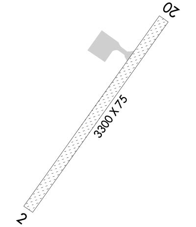
Runway Identifications
Runway Identification: 02/20Length: 3300 ft
Width: 75 ft
Surface: GRAVEL-POOR CONDITION
Edge lights: Medium IntensityTreatment: NONE
| | Runway: 02 | | Runway: 20 |
| Mag heading: | 23° | Mag heading: | 203° |
| Rwy Slope: | .11% Up | Rwy Slope: | -.11% Down |
| Approach: | | Approach: | |
| Pattern: | Left Traffic | Pattern: | Left Traffic |
| Markings: | | Markings: | |
| Marking Condition: | GOOD | Marking Condition: | GOOD |
| Arresting Dev: | | Arresting Dev: | |
| Lat & Long: | N5554.2 W15909.9 | Lat. & Long.: | N5554.6 W15909.4 |
| Elev: | 23.5 ft. MSL | Elev: | 27.0 ft. MSL |
| TCH: | 28 ft. AGL | TCH: | |
| Visual Glide Path: | 3.40 degrees | Visual Glide Path: | |
| Displaced Threshold: | No | Displaced Threshold: | No |
| Touchdown Zone: | YES | Touchdown Zone: | YES |
| Touchdown Elev.: | 29.9 feet | Touchdown Elev.: | 29.9 feet |
| Visual Glide Slope: | 4-Light PAPI on LEFT side of Runway | Visual Glide Slope: | |
| RVR Equipment: | | RVR Equipment: | |
| RVV Equipment: | NO | RVV Equipment: | NO |
| Approach Lights: | | Approach Lights: | |
| REIL: | YES | REIL: | NO |
| Centerline Lights: | NO | Centerline Lights: | NO |
| Touchdown lights: | NO | Touchdown lights: | NO |
| Runway Category: | Runway with a Non-precision Approach | Runway Category: | Runway with a Visual Approach |
| Declared Distances: | | Declared Distances: | |
| Obstructions: | HILL; 250 FT HILL 1 MILE S OF ARPT. | Obstructions: | HILL; 535 FT HILL 1 NM N OF ARPT. |
| Marked: | NOT Marked/Lighted | Marked: | NOT Marked/Lighted |
| Clearance slope: | 20:1 | Clearance slope: | 10:1 |
| Obstruction height: | 250 feet AGL | Obstruction height: | 477 feet AGL |
| Dist. from runway: | 5200 feet | Dist. from runway: | 5000 feet |
| Centerline offset: | 1053 right of centerline | Centerline offset: | 522 feet left of centerline |
| Comments: | | Comments: | |
