Click here for more info on on SMS!

PAPB

ST GEORGE
ST GEORGE
AK
Time Zone: Hawaii
Lat: N 5634.6
Long: W 16939.8
Elev: 128
Var: -07
Longest Runway: 4982
AWOS: 135.45
CTAF: 122.8

FBO & Flight Services info for PAPB

FBOs: Update your Fuel Prices

AIRPORT(UNATTND)Ph: 907-581-1786
-
Freq: 123.2
Service
Jet
100LL
SAF
MoGas
Fuel Avail: NO FUEL AVAILABLE
Full        Last Update: 04/17/2024 05:28:40

Self        
ASOSPh: 907-859-2700
-
Freq: 135.45  
If you are an FBO, call 1-203-262-1700 to update your info or email: FltPlan.Advertising@garmin.com
Advertise your FBO on FltPlan.com

Runway & Approach Info for PAPB
Rwy
Length
Land Dist**
Approach*
  Rwy
Length
Land Dist**
Approach*
11
4982x150  4982'          
LOC/GS
 110.10 - 111°  
  
29
  4982x150  4982'          
 
 * only ILS, LOC, LDA, and SDF approaches to a specific runway are shown
** For any Declared Landing Distance Available, please see A/FD or Approach plates
Runway Weight Capability (lbs.) Help
Runway IDSingle WheelDouble WheelDouble Tandem WheelDual Double Wheel
11/29N/AN/AN/AN/A
These numbers are Advisory and are not limits.   The Airport Manager should have more accurate Weight Limits
Approach Charts
Approaches    
Current Weather/Notams
Customs Information Send updates to Support@FltPlan.com
Customs Not Available
Database effective 04/18/2024
Airport Diagram of PAPB
Airport Diagram might not be current.

Facility Name: ST GEORGE
City Name: ST GEORGE
County: ALEUTIANS WEST
State abbrev: AK
State Name: ALASKA
   
Ownership: PUBLICLY OWNED
Use: OPEN TO THE PUBLIC
Owner's Name: ALASKA DOT&PF SOUTHCOAST REGION
Address: PO BOX 112506
 JUNEAU, AK 99811-2506
Owner's Phone: (907) 465-1779
  
Manager's Name: DALE RUCKMAN
Address: PO BOX 920525
 DUTCH HARBOR, AK 99692
Phone: (907) 581-1786
   
FAA Region: ALASKA
FAA Field Office: NONE


Sunrise / Sunset times for ST GEORGE

DateSunriseSunset
04/17/24 Wednesday6:0420:33
04/18/24 Thursday6:0120:35
04/19/24 Friday5:5920:38
04/20/24 Saturday5:5620:40
04/21/24 Sunday5:5420:42
04/22/24 Monday5:5120:44
04/23/24 Tuesday5:4920:46
04/24/24 Wednesday5:4620:48
04/25/24 Thursday5:4420:50
04/26/24 Friday5:4220:52
04/27/24 Saturday5:3920:54
04/28/24 Sunday5:3720:56
04/29/24 Monday5:3420:58
04/30/24 Tuesday5:3221:01

Airport Facilities

Airport Attendance ScheduleUNATTENDED
Airport Status OPERATIONAL (This Status can change at any time - please check NOTAMS)
Airport Lighting Schedule
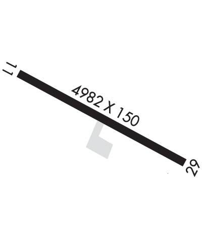
ACTVT HIRL RY 11/29, REIL RY 29; MALSF & PAPI RY 11, & WINDSOCK - CTAF.; ACTVT ROTG BCN - CTAF.
Airport Storage AvailableNONE
Extra Services AvailableNONE
Wind IndicatorYES - (lighted)
Control TowerNO
CTAF Frequency122.800
Unicom Frequency
Rotating Beacon ColorWG
Segmented CircleYES
Landing Fee

Airport Inspection Data

Airport InspectedFEDERAL - performed by PRIVATE CONTRACT PERSONNEL
Inspection Date08/29/2023

Airport Services

Type of Fuel AvailableNone
Airframe Repair ServiceNone
Power Plant Repair ServiceNone

Geographic Data

LatitudeN5634.6
LongitudeW16939.8 (ESTIMATED)
Arpt Elevation127ft (SURVEYED)
Magnetic Variation07E
4 miles SWof ST GEORGE
Traffic Pattern Altitude
Sectional ChartDUTCH HARBOR

Aircraft Data

Operations (Reported)YearlyAvg. Daily
General Aviation Transient 00
General Aviation Local 00
Air Taxi 00
Commerical 1560
Commuter 00
Military 00
Aircraft based on Field
General Aviation Singles 0
General Aviation Multi 0
Jet Aircraft 0
General Aviation Helicopters 0
Military Aircraft 0
Gliders 0
Ultralights 0

FAA Services

FSS on field NO
FSS tie-in KENAI
FSS Phone 1-800-866-864-1737
Who issues Notams PBV
Notam D service at airport YES
ARTCC Name ANCHORAGE

Federal Status

Airport Certification
Aircraft Rescue & Firefighting IndexNone
Airport of EntryNo
Custom Landing RightsNo
Joint Civil/MilitaryNo
Military Landing rightsYES

Federal Agreements

NATIONAL PLAN OF INTEGRATED AIRPORT SYSTEMS (NPIAS)
GRANT AGREEMENTS UNDER FAAP/ADAP/AIP
ASSURANCES PURSUANT TO TITLE VI, CIVIL RIGHTS ACT OF 1964

Remarks

LARGE CONCENTRATIONS OF SEABIRDS INVOF ARPT. REINDEER AND FOX INVOF ARPT.
PILOTS ARE REQUESTED TO AVOID FLIGHTS BELOW 1000 FT AGL FROM MAY 14 THROUGH DEC 14 IN THOSE AREAS OF ST. GEORGE ISLAND WITH ACTIVE BIRD POPULATIONS AND COASTAL SEAL ROOKERIES.
Airport Communications & Frequencies:
CTAF Frequency:
122.800
Remarks
  • APCH/DEP SVC PRVDD BY ANCHORAGE ARTCC ON FREQS 119.1/339.8 (SAINT PAUL ISLAND RCAG).
  • Runway Identifications
    Runway Identification: 11/29
    Length: 4982 ft
    Width: 150 ft
    Surface: ASPHALT-GOOD CONDITION
    Edge lights: High Intensity

    Treatment: GROOVED

     Runway: 11   Runway: 29
    Mag heading: 111°Mag heading: 291°
    Rwy Slope: -.09% DownRwy Slope: .09% Up
    Approach: LOC/GSApproach:
    Pattern: Right TrafficPattern: Left Traffic
    Markings: PRECISION INSTRUMENTMarkings: PRECISION INSTRUMENT
    Marking Condition: FAIRMarking Condition: FAIR
    Arresting Dev: Arresting Dev:
    Lat & Long: N5634.8  W16940.5Lat. & Long.: N5634.4  W16939.2
    Elev: 127.9 ft. MSLElev: 123.4 ft. MSL
    TCH: 56 ft. AGLTCH:
    Visual Glide Path: 3.60 degreesVisual Glide Path:
    Displaced Threshold: NoDisplaced Threshold: No
    Touchdown Zone: YESTouchdown Zone: YES
    Touchdown Elev.: 127.9 feetTouchdown Elev.: 123.4 feet
    Visual Glide Slope: 4-Light PAPI on LEFT side of RunwayVisual Glide Slope:
    RVR Equipment: RVR Equipment:
    RVV Equipment: NORVV Equipment: NO
    Approach Lights: MALSF - 1,400 foot medium intensity approach lighting system with sequenced flashersApproach Lights:
    REIL: NOREIL: YES
    Centerline Lights: NOCenterline Lights: NO
    Touchdown lights: NOTouchdown lights: NO
    Runway Category: Precision Instrument RunwayRunway Category: Runway with a Visual Approach
    Declared Distances: Declared Distances:
    Obstructions: ROADObstructions: HILL
    Marked: NOT Marked/LightedMarked: NOT Marked/Lighted
    Clearance slope: CONTROLLING OBSTRUCTION EXCEEDS A 45 DEGREE SLOPEClearance slope:
    Obstruction height: 15 feet AGLObstruction height: 35 feet AGL
    Dist. from runway: 200 feetDist. from runway: 200 feet
    Centerline offset: Centerline offset: 250 feet right of centerline
    Comments: ROAD BEGINNING AT EDGES OF THE END OF RWY EXTENDING OUT TO 200 FT MERGING APPX ON CENTERLINE.Comments: ROAD BEGINNING AT RIGHT EDGE AND END OF RWY AND EXTENDS OUT TO 200 FT APPX PARALLEL TO RWY CENTERLINE.
    C:/P: