Click here for more info on on SMS!

PAOT

RALPH WIEN MEMORIAL
KOTZEBUE
AK
Time Zone: Alaska
Lat: N 6653.1
Long: W 16235.9
Elev: 15
Var: -11
Longest Runway: 6300
Dept. ATIS: 135.45
Arr. ATIS: 135.45
AWOS: 135.45
CTAF: 123.6

FBO & Flight Services info for PAOT

FBOs: Update your Fuel Prices

CROWLEY FUELSPh: 907-442-3211 Fax: 907-442-3627 Freq: 122.8
Service
Jet
100LL
SAF
MoGas
Fuel Avail: PRIST + $0.12/gal Prices are into wings, taxes included.
Full8.0010.00    Last Update: 03/22/2024 13:23

Self        
 Address: 640 THIRD AVAE   KOTZEBUE, AK 99752
BERING AIRPh: 907-442-3187
-
-
Service
Jet
100LL
SAF
MoGas
Fuel Avail: PRIST + $0.10/gal
Full9.0011.00    Last Update: 03/22/2024 13:24

Self        
ASOSPh: 907-442-2279
-
Freq: 135.45  
If you are an FBO, call 1-203-262-1700 to update your info or email: FltPlan.Advertising@garmin.com
Advertise your FBO on FltPlan.com

Runway & Approach Info for PAOT
Rwy
Length
Land Dist**
Approach*
  Rwy
Length
Land Dist**
Approach*
09
6300x150  5900'          
ILS/DME
 110.70 - 088°  
  
27
  6300x150  6300'          
 
18
3876x90  3876'          
 
  
36
  3876x90  3876'          
 
 * only ILS, LOC, LDA, and SDF approaches to a specific runway are shown
** For any Declared Landing Distance Available, please see A/FD or Approach plates
Runway Weight Capability (lbs.) Help
Runway IDSingle WheelDouble WheelDouble Tandem WheelDual Double Wheel
09/27100,000128,000240,000N/A
18/36N/AN/AN/AN/A
These numbers are Advisory and are not limits.   The Airport Manager should have more accurate Weight Limits
Approach Charts
Approaches    
Current Weather/Notams
Customs Information Send updates to Support@FltPlan.com
Customs Not Available
Database effective 04/18/2024
Airport Diagram of PAOT
Airport Diagram might not be current.

Facility Name: RALPH WIEN MEML
City Name: KOTZEBUE
County: NORTHWEST ARCTIC
State abbrev: AK
State Name: ALASKA
   
Ownership: PUBLICLY OWNED
Use: OPEN TO THE PUBLIC
Owner's Name: ALASKA DOT&PF NORTHERN REGION
Address: 2301 PEGER RD
 FAIRBANKS, AK 99701
Owner's Phone: 907-443-3411
  
Manager's Name: ALVIN WERNEKE
Address: BOX 55
 KOTZEBUE, AK 99752
Phone: 907-442-3147
   
FAA Region: ALASKA
FAA Field Office: NONE


Sunrise / Sunset times for RALPH WIEN MEML

DateSunriseSunset
04/18/24 Thursday6:4922:52
04/19/24 Friday6:4522:56
04/20/24 Saturday6:4123:00
04/21/24 Sunday6:3623:03
04/22/24 Monday6:3223:07
04/23/24 Tuesday6:2823:11
04/24/24 Wednesday6:2423:15
04/25/24 Thursday6:2023:19
04/26/24 Friday6:1623:23
04/27/24 Saturday6:1123:26
04/28/24 Sunday6:0723:30
04/29/24 Monday6:0323:34
04/30/24 Tuesday5:5923:38
05/01/24 Wednesday5:5523:42

Airport Facilities

Airport Attendance ScheduleWED-MON 0700-2359, TUE 0700-2359
Airport Status OPERATIONAL (This Status can change at any time - please check NOTAMS)
Airport Lighting Schedule
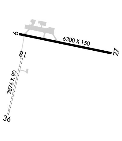
ACTVT REIL RWY 09 & 27 - CTAF. HIRL RWY 09/27; MIRL RWY 18/36 ON 0700-2400; OTR TIME - CTAF. PAPI RWY 09 & 27 ON CONSLY.
Airport Storage AvailableHanger
Extra Services AvailableCargo Handling
Wind IndicatorYES - (lighted)
Control TowerNO
CTAF Frequency123.600
Unicom Frequency122.800
Rotating Beacon ColorWG
Segmented CircleYES
Landing FeeNO

Airport Inspection Data

Airport InspectedFEDERAL - performed by FAA AIRPORTS FIELD PERSONNEL
Inspection Date06/22/2023

Airport Services

Type of Fuel AvailableGrade 100, JET A (freeze point -40C)
Airframe Repair ServiceMINOR
Power Plant Repair ServiceMINOR

Geographic Data

LatitudeN6653.1
LongitudeW16235.9 (ESTIMATED)
Arpt Elevation15ft (SURVEYED)
Magnetic Variation11E
1 miles Sof KOTZEBUE
Traffic Pattern Altitude
Sectional ChartNOME

Aircraft Data

Operations (Reported)YearlyAvg. Daily
General Aviation Transient 3000082
General Aviation Local 700019
Air Taxi 2000055
Commerical 20005
Commuter 00
Military 10003
Aircraft based on Field
General Aviation Singles 37
General Aviation Multi 6
Jet Aircraft 0
General Aviation Helicopters 0
Military Aircraft 0
Gliders 0
Ultralights 0

FAA Services

FSS on field YES
FSS tie-in KOTZEBUE
FSS Phone 1-800-800-478-7460
Nearby FSS FAIRBANKS
Phone 1-800-866-248-6516
Who issues Notams OTZ
Notam D service at airport YES
ARTCC Name ANCHORAGE

Federal Status

Airport CertificationAIRPORT RECEIVING SCHEDULED AIR CARRIER SERVICE FROM CARRIERS CERTIFICATED BY THE CIVIL AERONAUTICS BOARD; CLSD TO ACR OPS MORE THAN 30 PAX SEATS EXC PPR IN WRITING - AMGR BOX 55 KOTZEBUE AK 99752.
Aircraft Rescue & Firefighting IndexAIRPORT HAS A CERTIFICATE UNDER CFR PART 139
Airport of EntryNo
Custom Landing RightsNo
Joint Civil/MilitaryNo
Military Landing rightsYES

Federal Agreements

NATIONAL PLAN OF INTEGRATED AIRPORT SYSTEMS (NPIAS)
GRANT AGREEMENTS UNDER FAAP/ADAP/AIP
CONVEYANCE UNDER SCETION 16, FEDERAL AIRPORT ACT OF 1946 OR SECTION 23, AIRPORT AND AIRWAY DEVELOPMENT ACT OF 1970
ASSURANCES PURSUANT TO TITLE VI, CIVIL RIGHTS ACT OF 1964

Remarks

NMRS 330 FT WIND TURBINE TWRS 3.5 MI SE.
WX CAMERA AVBL ON INTERNET AT HTTPS://WEATHERCAMS.FAA.GOV
RAVENS INVOF ARPT.
TSA REGULATED: SEE 49 CFR 1542; ALL GATES & DOORS SECURED ALL TIMES; INFO - AMGR.
IREG SFC TWY E 175 FT SW.
ARPT SVCS AVBL 0700-2000; AFT HR - AMGR.
PRKG AREA UNLGTD. TSNT PRKG - FLT SVC.
TWYS & RAMPS HAVE NMRS DIPS & ROUGH SFCS.
SAND LRGR GRADATION THAN FAA RCMDD/SEE AC150/5200-30.
RWY 09/2 7 LOCKED WHEEL TURNS NA.
RWY 18/3 6 NOT AVBL FOR SKED OR UNSKED ACR OPS MORE THAN 30 PAX SEATS. PPR WINGSPAN MORE THAN 49 FT - AMGR. UNCTLD VEHICLE ACES.
RWY 09 IREG SFC 1175 FT E OF THR.
RWY 09/2 7 EXTD 30 IN ABV GND.
RWY 18/3 6 EXTD 30 IN ABV GND.
Airport Communications & Frequencies:
CTAF Frequency:
123.600
Unicom Frequency:
122.800
Remarks
  • APCH/DEP SVC PRVDD BY ANCHORAGE ARTCC ON FREQS 119.2/263.0 (KOTZEBUE RCAG).
  • OTZ AFIS ON FREQUENCY 135.45. OPERATES SAME HRS AS OTZ FSS, 0700-0000; OT FAIRBANKS FSS.
  • COMMUNICATIONS PRVDD BY KOTZEBUE FSS ON FREQ 123.6 (CTAF).
  • Runway Identifications
    Runway Identification: 09/27
    Length: 6300 ft
    Width: 150 ft
    Surface: ASPHALT-GOOD CONDITION
    Edge lights: High Intensity

    Treatment: GROOVED
    Weight: PCN 91 /F/B/X/T

     Runway: 09   Runway: 27
    Mag heading: 91°Mag heading: 271°
    Rwy Slope: .04% UpRwy Slope: -.04% Down
    Approach: ILS/DMEApproach:
    Pattern: Left TrafficPattern: Left Traffic
    Markings: PRECISION INSTRUMENTMarkings: NONPRECISION INSTRUMENT
    Marking Condition: FAIRMarking Condition: FAIR
    Arresting Dev: Arresting Dev:
    Lat & Long: N6653.4  W16236.6Lat. & Long.: N6653.2  W16234.1
    Elev: 12.8 ft. MSLElev: 15.4 ft. MSL
    TCH: 43 ft. AGLTCH: 46 ft. AGL
    Visual Glide Path: 3.00 degreesVisual Glide Path: 3.30 degrees
    Displaced Threshold: 400 feetDisplaced Threshold: No
    Touchdown Zone: YESTouchdown Zone: YES
    Touchdown Elev.: 13.2 feetTouchdown Elev.: 15.4 feet
    Visual Glide Slope: 4-Light PAPI on RIGHT side of RunwayVisual Glide Slope: 4-Light PAPI on LEFT side of Runway
    RVR Equipment: TOUCHDOWNRVR Equipment: ROLLOUT
    RVV Equipment: NORVV Equipment: NO
    Approach Lights: Approach Lights:
    REIL: YESREIL: YES
    Centerline Lights: NOCenterline Lights: NO
    Touchdown lights: NOTouchdown lights: NO
    Runway Category: Precision Instrument RunwayRunway Category: Runway with a Non-precision Approach having visibility minimums greater than 3/4 mile
    Declared Distances: TORA:6300' TODA:6300' ASDA:6300' LDA:5900'Declared Distances: TORA:5900' TODA:5900' ASDA:5900' LDA:5900'
    Obstructions: ROADObstructions: HILL
    Marked: NOT Marked/LightedMarked: NOT Marked/Lighted
    Clearance slope: Clearance slope: 15:1
    Obstruction height: 15 feet AGLObstruction height: 38 feet AGL
    Dist. from runway: 30 feetDist. from runway: 800 feet
    Centerline offset: Centerline offset:
    Comments: ROAD 430 FT FM THR; VEHICLE HGT LTD TO 13 FT.Comments:
    Runway Identification: 18/36
    Length: 3876 ft
    Width: 90 ft
    Surface: -FAIR CONDITION
    Edge lights: Medium Intensity

    Treatment: NONE

     Runway: 18   Runway: 36
    Mag heading: 183°Mag heading:
    Rwy Slope: -.01% DownRwy Slope: .01% Up
    Approach: Approach:
    Pattern: Left TrafficPattern: Left Traffic
    Markings: Markings:
    Marking Condition: Marking Condition:
    Arresting Dev: Arresting Dev:
    Lat & Long: N6653.1  W16236.6Lat. & Long.: N6652.5  W16236.9
    Elev: 11.2 ft. MSLElev: 10.8 ft. MSL
    TCH: TCH:
    Visual Glide Path: Visual Glide Path:
    Displaced Threshold: NoDisplaced Threshold: No
    Touchdown Zone: YESTouchdown Zone: YES
    Touchdown Elev.: 11.4 feetTouchdown Elev.: 11.4 feet
    Visual Glide Slope: Visual Glide Slope:
    RVR Equipment: RVR Equipment:
    RVV Equipment: NORVV Equipment: NO
    Approach Lights: Approach Lights:
    REIL: NOREIL: NO
    Centerline Lights: NOCenterline Lights: NO
    Touchdown lights: NOTouchdown lights: NO
    Runway Category: Runway with a Visual ApproachRunway Category: Runway with a Visual Approach
    Declared Distances: Declared Distances:
    Obstructions: ROADObstructions: Unknown
    Marked: NOT Marked/LightedMarked: NOT Marked/Lighted
    Clearance slope: 26:1Clearance slope: 50:1
    Obstruction height: 15 feet AGLObstruction height: 15 feet AGL
    Dist. from runway: 400 feetDist. from runway:
    Centerline offset: Centerline offset:
    Comments: Comments:
    C:4/P: